Tinbeerwah, Queensland
Tinbeerwah is a semi-rural locality in the Shire of Noosa, Queensland, Australia.[2] In the 2021 census, Tinbeerwah had a population of 1,160 people.[3]
| Tinbeerwah Queensland | |||||||||||||||
|---|---|---|---|---|---|---|---|---|---|---|---|---|---|---|---|
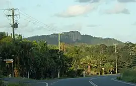
 Coveys Rd, Tinbeerwah, 2016 | |||||||||||||||
 Tinbeerwah | |||||||||||||||
| Coordinates | 26.4066°S 152.9761°E | ||||||||||||||
| Population | 1,160 (SAL 2021)[1] | ||||||||||||||
| Postcode(s) | 4563 | ||||||||||||||
| Area | 22.1 km2 (8.5 sq mi) | ||||||||||||||
| Time zone | AEST (UTC+10:00) | ||||||||||||||
| Location |
| ||||||||||||||
| LGA(s) | Shire of Noosa | ||||||||||||||
| State electorate(s) | Noosa | ||||||||||||||
| Federal division(s) | Wide Bay | ||||||||||||||
| |||||||||||||||
Geography
The Cooroy-Noosa Road runs through from west (Lake Macdonald) to east (Tewantin).[4]
Mount Tinbeerwah is in the north of locality (26.3902°S 152.9752°E) rising 265 metres (869 ft) above sea level.[5][6]
The north of the locality is within the Tewantin National Park.[7]
History
The name Tinbeerwah is Aboriginal for "place of grasstrees" or "high hill climbing up".[8][9]
Tinbeerwah Provisional School opened on 2 September 1914. On 1 September 1916, it became Tinbeerwah State School. It closed on 9 August 1963.[10]
In 1987, 12-year-old Noosa schoolgirl Sian Kingi was raped and murdered in Tinbeerwah after being abducted from Noosa Heads.[11][12]
Between 2008 and 2013, Tinbeerwah (and the rest of the Shire of Noosa) was within Sunshine Coast Region but the Shire of Noosa was re-established in 2014.[13][14]
Demographics
In the 2011 census, Tinbeerwah had a population of 1,262.[15]
In the 2016 census, Tinbeerwah had a population of 974 people.[16]
In the 2021 census, Tinbeerwah had a population of 1,160 people.[3]
Education
There are no schools in Tinbeerwah. The nearest government primary schools are:[7]
- Tewantin State School in neighbouring Tewantin to the east
- Eumundi State School in neighbouring Eumundi to the south
- Cooroy State School in Cooroy to the south-west
- Noosaville State School in Noosaville to the east
The nearest government secondary school is Noosa District State High School which has its junior campus in Pomona to the north-west and its senior campus in Cooroy to the south-west.[7]
References
- Australian Bureau of Statistics (28 June 2022). "Tinbeerwah (Suburb and Locality)". Australian Census 2021 QuickStats. Retrieved 28 June 2022.
- "Tinbeerwah – locality in Shire of Noosa (entry 48902)". Queensland Place Names. Queensland Government. Retrieved 16 November 2019.
- Australian Bureau of Statistics (28 June 2022). "Tinbeerwah (SAL)". 2021 Census QuickStats. Retrieved 28 February 2023.
- Google (4 July 2023). "Tinbeerwah, Queensland" (Map). Google Maps. Google. Retrieved 4 July 2023.
- "Mountain peaks and capes - Queensland". Queensland Open Data. Queensland Government. 12 November 2020. Archived from the original on 25 November 2020. Retrieved 25 November 2020.
- "Mount Tinbeerwah – mountain in Shire of Noosa (entry 34611)". Queensland Place Names. Queensland Government. Retrieved 8 March 2023.
- "Queensland Globe". State of Queensland. Retrieved 22 August 2023.
- Noosa Community Guide 2005 Part D Archived 24 July 2008 at the Wayback Machine 19 December 2006
- South East Queensland – Place Names Archived 21 August 2006 at the Wayback Machine 19 December 2006
- Queensland Family History Society (2010), Queensland schools past and present (Version 1.01 ed.), Queensland Family History Society, ISBN 978-1-921171-26-0
- Read, Cloe (14 October 2021). "Murderer of Queensland schoolgirl Sian Kingi loses bid for parole". Brisbane Times. Archived from the original on 16 October 2021. Retrieved 22 August 2023.
- Doneman, Paula (11 June 2021). "Tracking the evil union of one of Australia's most sadistic couples". ABC News. Archived from the original on 25 December 2022. Retrieved 22 August 2023.
- "Backward Glance: History of Local Government on the Sunshine Coast". Sunshine Coast Regional Council. Archived from the original on 2 August 2023. Retrieved 2 August 2023.
- "The Noosa De-amalgamation: Building a New Organisation". Noosa Shire Council. 2 January 2014. pp. 8–9. Archived from the original on 6 April 2023. Retrieved 2 August 2023.
- Australian Bureau of Statistics (31 October 2012). "Tinbeerwah (State Suburb)". 2011 Census QuickStats. Retrieved 9 October 2014.
- Australian Bureau of Statistics (27 June 2017). "Tinbeerwah (SSC)". 2016 Census QuickStats. Retrieved 20 October 2018.
External links
- "Tinbeerwah". Queensland Places. University of Queensland.