Bomê County
Pome County[3][4] (Tibetan: སྤོ་མེས་རྫོང)[2] or Bomê County (Chinese: 波密县)[2] is a county of Nyingchi Prefecture in the south-east of the Tibet Autonomous Region.[4] Historically known as Powo or Poyul, it was the seat of a quasi-independent kingdom until the early 20th century when troops of the Dalai Lama's Lhasa government integrated it into the central Tibetan realm. The population was 25,897 in 2004.[4]
Pome County
波密县 • སྤོ་མེས་རྫོང་ Bomê | |
|---|---|
| Bomê County | |
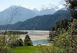
 Gangxiang Nature Reserve | |
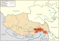
.png.webp) Location of Pome County (red) within Nyingchi City (yellow) and the Tibet Autonomous Region | |
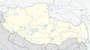
 Pome Location of the seat in Tibet  Pome Pome (China) | |
| Coordinates: 29.850°N 95.775°E | |
| Country | China |
| Autonomous region | Tibet |
| Prefecture-level city | Nyingchi |
| County seat | Tramog |
| Area | |
| • Total | 16,072 km2 (6,205 sq mi) |
| Population (2020)[1] | |
| • Total | 34,858 |
| • Density | 2.2/km2 (5.6/sq mi) |
| Time zone | UTC+8 (China Standard) |
| Website | www |
| Bomê County | |||||||||||
|---|---|---|---|---|---|---|---|---|---|---|---|
| Chinese name | |||||||||||
| Simplified Chinese | 波密县 | ||||||||||
| Traditional Chinese | 波密縣 | ||||||||||
| |||||||||||
| Tibetan name | |||||||||||
| Tibetan | སྤོ་མེས་རྫོང་ | ||||||||||
| |||||||||||
Geography
The region of Powo or Poyul, which is now constituted as the Pome County, lies to the northeast of the Tsangpo gorge, where the Yarlung Tsangpo (Brahmaputra) river turns abruptly to the south on its course towards India.[5]
Two major rivers Yi'ong Tsangpo and Parlung Tsangpo flow into the Pome County from opposite directions to join near Tang-me. The combined river (called Yi'ong Tsangpo) exits the Pome County to the south to join Yarlung Tsangpo near Mount Gyala Peri.[4][6]
The lower reaches of these two rivers constitute Po-me or Lower Powo.[4]
Po-to or Upper Powo consists of the basin of another river Poto Tsangpo, which originates within the Pome County, along with its tributary Yarlung Chu. Poto Tsangpo joins Parlung Tsangpo to the west of the "Pome Town" (Tramog).[4]
History
The Kingdom of Powo, or sPo yul (“country of sPo”) was an offshoot of the ancient dynasty of the first Tibetan kings of the Yarlung Valley. Its inhabitants had a reputation as fearsome savages which meant most travellers kept clear of it and so it was one of the least known areas in the Tibetan traditional feudal establishment.
Its isolation was also enhanced by the belief by a great number of Tibetans that in its borders was one of the 'hidden lands' or beyul (Standard Tibetan: sbas-yul) referred to in the prophecies of Guru Rinpoche. Poba's area of control far exceeded the boundaries of Pome County. The kingdom acted as a protecting power for the streams of Tibetan pilgrims searching for this Promised Land in the East Himalayas from the Lopa tribes (Assam Himalayan tribes) from the mid-seventeenth century. Its power extended south over the Doshong La pass, to include the location of one of these earthly paradises called "Padma bkod" (written variously Pema köd, Pemakö and Pemako), literally 'Lotus Array', a region in the North-Eastern Province of Upper Siang of Arunachal Pradesh. Accounts of this terrestrial paradise influenced James Hilton's Shangri-La. A period of instability overtook the kingdom after Chinese incursions in 1905 and 1911. By 1931 the Lhasa government had expelled the last Ka gnam sde pa ('king') and established two garrisons.
Climate
Pome has a monsoon-influenced oceanic climate (Köppen climate classification Cwb). The average annual temperature in Pome is 9.0 °C (48.2 °F). The average annual rainfall is 890.9 mm (35.07 in) with June as the wettest month. The temperatures are highest on average in July, at around 16.9 °C (62.4 °F), and lowest in January, at around 0.7 °C (33.3 °F).
| Climate data for Pome County (1991–2020 normals, extremes 1981–2010) | |||||||||||||
|---|---|---|---|---|---|---|---|---|---|---|---|---|---|
| Month | Jan | Feb | Mar | Apr | May | Jun | Jul | Aug | Sep | Oct | Nov | Dec | Year |
| Record high °C (°F) | 17.8 (64.0) |
19.1 (66.4) |
21.9 (71.4) |
25.3 (77.5) |
28.1 (82.6) |
30.2 (86.4) |
31.2 (88.2) |
31.0 (87.8) |
29.5 (85.1) |
25.4 (77.7) |
19.7 (67.5) |
16.1 (61.0) |
31.2 (88.2) |
| Average high °C (°F) | 8.9 (48.0) |
10.4 (50.7) |
12.5 (54.5) |
16.0 (60.8) |
19.3 (66.7) |
21.8 (71.2) |
23.8 (74.8) |
23.9 (75.0) |
21.3 (70.3) |
16.8 (62.2) |
13.4 (56.1) |
10.3 (50.5) |
16.5 (61.7) |
| Daily mean °C (°F) | 0.9 (33.6) |
3.2 (37.8) |
5.8 (42.4) |
9.0 (48.2) |
12.3 (54.1) |
15.5 (59.9) |
17.2 (63.0) |
16.9 (62.4) |
14.6 (58.3) |
9.9 (49.8) |
4.9 (40.8) |
1.4 (34.5) |
9.3 (48.7) |
| Average low °C (°F) | −4.8 (23.4) |
−1.9 (28.6) |
1.3 (34.3) |
4.2 (39.6) |
7.5 (45.5) |
11.3 (52.3) |
12.7 (54.9) |
12.5 (54.5) |
10.6 (51.1) |
5.7 (42.3) |
−0.5 (31.1) |
−4.5 (23.9) |
4.5 (40.1) |
| Record low °C (°F) | −14.5 (5.9) |
−12.0 (10.4) |
−10.1 (13.8) |
−4.4 (24.1) |
−1.7 (28.9) |
2.2 (36.0) |
4.2 (39.6) |
4.6 (40.3) |
0.4 (32.7) |
−5.7 (21.7) |
−10.0 (14.0) |
−13.7 (7.3) |
−14.5 (5.9) |
| Average precipitation mm (inches) | 5.0 (0.20) |
27.0 (1.06) |
85.7 (3.37) |
112.6 (4.43) |
116.0 (4.57) |
127.1 (5.00) |
105.3 (4.15) |
89.2 (3.51) |
103.9 (4.09) |
84.4 (3.32) |
17.5 (0.69) |
4.8 (0.19) |
878.5 (34.58) |
| Average precipitation days (≥ 0.1 mm) | 4.0 | 8.2 | 16.3 | 17.7 | 20.1 | 23.6 | 23.4 | 22.3 | 22.3 | 15.6 | 6.1 | 3.2 | 182.8 |
| Average snowy days | 6.6 | 8.4 | 5.1 | 0.9 | 0.1 | 0 | 0 | 0 | 0.1 | 0.2 | 1.4 | 3.8 | 26.6 |
| Average relative humidity (%) | 60 | 63 | 70 | 70 | 71 | 76 | 76 | 75 | 78 | 76 | 68 | 62 | 70 |
| Mean monthly sunshine hours | 144.9 | 119.8 | 120.8 | 119.7 | 122.8 | 94.3 | 116.0 | 120.5 | 92.7 | 104.5 | 137.9 | 157.9 | 1,451.8 |
| Percent possible sunshine | 45 | 38 | 32 | 31 | 29 | 22 | 27 | 30 | 25 | 30 | 44 | 50 | 34 |
| Source: China Meteorological Administration[7][8] | |||||||||||||
Administrative divisions
Bomê County contains 3 towns and 7 townships.
| Name | Chinese | Hanyu Pinyin | Tibetan | Wylie |
|---|---|---|---|---|
| Towns | ||||
| Zhamo Town (Tramog) |
扎木镇 | Zhāmù zhèn | སྤྲ་རྨོག་གྲོང་རྡལ། | sprag rmog grong rdal |
| Chumdo Town | 倾多镇 | Qīngduō zhèn | ཆུ་མདོ་གྲོང་རྡལ། | chu mdo grong rdal |
| Sumzom Town | 松宗镇 | Sōngzōng zhèn | གསུམ་འཛོམས་གྲོང་རྡལ། | gsum 'dzoms grong rdal |
| Townships | ||||
| Yi'ong Township | 易贡乡 | Yìgòng xiāng | ཡིད་འོང་ཤང་། | yid 'ong shang |
| Yupuk Township | 玉普乡 | Yùpǔ xiāng | གཡུ་ཕུག་ཤང་། | gyu phug shang |
| Kangyul Township | 康玉乡 | Kāngyù xiāng | ཁང་ཡུལ་ཤང་། | khang yul shang |
| Dorjé Township | 多吉乡 | Duōjí xiāng | རྡོ་རྗེ་ཤང་། | rdo rje shang |
| Shulmo Township | 玉许乡 | Yùxǔ xiāng | ཤུལ་མོ་ཤང་། | shul mo shang |
| Paggai Township | 八盖乡 | Bāgài xiāng | བྲག་སྐས་ཤང་། | brag skas shang |
| Gu Township | 古乡 | Gǔ xiāng | དགུ་ཤང་། | dgu shang |
Transport
References
- "林芝市第七次全国人口普查主要数据公报" (in Chinese). Government of Nyingchi. 2021-06-17.
- "Geographical names of Tibet AR (China): Nyingchi prefecture-level city". KNAB Place Name Database. Institute of the Estonian Language. 2018-06-03.
- Tibet 2002: A Year Book, London: Tibet Information Network, p. 145, ISBN 0-9541961-5-5
- Dorje, Gyurme (2004), Footprint Tibet Handbook with Bhutan (3rd ed.), Bath: Footprint Handbooks, p. 430, ISBN 1-903471-30-3 – via archive.org
- Lamb, The McMahon Line, Vol. 2 (1966), p. 275.
- Pome County, OpenStreetMap, retrieved 22 September 2022.
- 中国气象数据网 – WeatherBk Data (in Simplified Chinese). China Meteorological Administration. Retrieved 27 August 2023.
- 中国气象数据网 (in Simplified Chinese). China Meteorological Administration. Retrieved 27 August 2023.
Bibliography
- Lamb, Alastair (1966), The McMahon Line: a Study in the Relations Between, India, China and Tibet, 1904 to 1914, Vol. 2: Hardinge, McMahon and the Simla Conference, Routledge & K. Paul – via archive.org
- Mehra, Parshotam (1974), The McMahon Line and After: A Study of the Triangular Contest on India's North-eastern Frontier Between Britain, China and Tibet, 1904-47, Macmillan, ISBN 9780333157374 – via archive.org
External links
- Pome County, OpenStreetMap, retrieved 21 September 2022.
- Yi'ong Tsangpo basin, Parlung Tsangpo basin, and both the rivers as part of the Yarlung Tsangpo basin, OpenStreetMap, retrieved 21 September 2022.
- (in Chinese) Official Website of Pome County
- Pemako trekking holiday, India


