Prostějov District
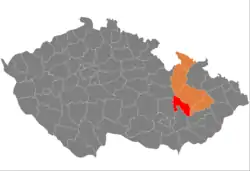
Prostějov District (Czech: okres Prostějov) is a district in the Olomouc Region of the Czech Republic. Its capital is the city of Prostějov.
Prostějov District
Okres Prostějov | |
|---|---|
 Location in the Olomouc Region within the Czech Republic | |
| Coordinates: 49°30′N 17°6′E | |
| Country | |
| Region | Olomouc |
| Capital | Prostějov |
| Area | |
| • Total | 777.09 km2 (300.04 sq mi) |
| Population (2023)[2] | |
| • Total | 108,717 |
| • Density | 140/km2 (360/sq mi) |
| Time zone | UTC+1 (CET) |
| • Summer (DST) | UTC+2 (CEST) |
| Municipalities | 97 |
| * Cities and towns | 5 |
| * Market towns | 6 |
Administrative division
Prostějov District is divided into two administrative districts of municipalities with extended competence: Prostějov and Konice.
List of municipalities
Cities and towns are marked in bold and market towns in italics:
Alojzov - Bedihošť - Bílovice-Lutotín - Biskupice - Bohuslavice - Bousín - Březsko - Brodek u Konice - Brodek u Prostějova - Budětsko - Buková - Čechy pod Kosířem - Čehovice - Čelčice - Čelechovice na Hané - Dětkovice - Dobrochov - Dobromilice - Doloplazy - Drahany - Dřevnovice - Držovice - Dzbel - Hačky - Hluchov - Horní Štěpánov - Hradčany-Kobeřice - Hrdibořice - Hrubčice - Hruška - Hvozd - Ivaň - Jesenec - Kladky - Klenovice na Hané - Klopotovice - Konice - Kostelec na Hané - Koválovice-Osíčany - Kralice na Hané - Krumsín - Laškov - Lešany - Lipová - Ludmírov - Malé Hradisko - Mořice - Mostkovice - Myslejovice - Němčice nad Hanou - Nezamyslice - Niva - Obědkovice - Ochoz - Ohrozim - Olšany u Prostějova - Ondratice - Otaslavice - Otinoves - Pavlovice u Kojetína - Pěnčín - Pivín - Plumlov - Polomí - Přemyslovice - Prostějov - Prostějovičky - Protivanov - Ptení - Raková u Konice - Rakůvka - Rozstání - Seloutky - Skalka - Skřípov - Slatinky - Smržice - Srbce - Stařechovice - Stínava - Stražisko - Šubířov - Suchdol - Tištín - Tvorovice - Určice - Víceměřice - Vícov - Vincencov - Vitčice - Vranovice-Kelčice - Vrbátky - Vrchoslavice - Vřesovice - Výšovice - Zdětín - Želeč
Geography

The landscape is varied and rugged. The terrain is flat in the southeast and hilly in the northwest. The territory extends into five geomorphological mesoregions: Drahany Highlands (west), Upper Morava Valley (east), Zábřeh Highlands (north), Vyškov Gate (south), and Litenčice Hills (south). The highest point of the district is the hill Skalky in Buková with an elevation of 735 m (2,411 ft), the lowest point is a meadow in Ivaň at 196 m (643 ft).
From the total district area of 777.1 km2 (300.0 sq mi), agricultural land occupies 531.9 km2 (205.4 sq mi), forests occupy 157.1 km2 (60.7 sq mi), and water area occupies 7.4 km2 (2.9 sq mi). Forests cover 20.2% of the district's area.[1]
There are no major rivers. The longest river is the Romže/Valová, which originates here and flows across the territory to the southeast. The Haná crosses the district in its southern part. The district is poor in bodies of water. The only notable body of water is the Plumlov Reservoir.
There are no large-scale protected areas.
Demographics
|
|
| ||||||||||||||||||||||||||||||||||||||||||||||||||||||
| Source: Censuses[3][4] | ||||||||||||||||||||||||||||||||||||||||||||||||||||||||
Most populated municipalities
| Name | Population[2] | Area (km2) |
|---|---|---|
| Prostějov | 43,551 | 39 |
| Kostelec na Hané | 2,872 | 14 |
| Konice | 2,666 | 24 |
| Plumlov | 2,300 | 12 |
| Němčice nad Hanou | 1,918 | 12 |
| Olšany u Prostějova | 1,839 | 11 |
| Vrbátky | 1,770 | 13 |
| Kralice na Hané | 1,697 | 13 |
| Mostkovice | 1,606 | 8 |
| Smržice | 1,605 | 13 |
Economy
The largest employers with headquarters in Prostějov District and at least 500 employees are:[5]
| Economic entity | Location | Number of employees | Main activity |
|---|---|---|---|
| AGEL Středomoravská nemocniční | Prostějov | 2,500–2,999 | Health care |
| Makovec | Prostějov | 1,000–1,499 | Processing of meat |
| Mubea Stabilizer Bar Systems | Prostějov | 1,000–1,499 | Manufacture of automotive parts |
| Windmöller & Hölscher Machinery | Kralice na Hané | 500–999 | Manufacture of plastics and rubber machinery |
Transport
The D1 motorway from Brno to Ostrava passes through the southern part of the district. The D46 motorway (part of the European route E462) separates from the D1 and leads from Vyškov to Olomouc across the district.
Sights

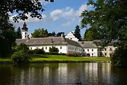
The most important monuments in the district, protected as national cultural monuments, are:[6]
The best-preserved settlement and the only one protected as a monument zone is Prostějov.[7]
There are no major tourist destinations. The most visited tourist destination is the Museum and Gallery in Prostějov.[8][9]
Notable people
References
- "Land use (as at 31 December)". Public database. Czech Statistical Office. Retrieved 2023-05-18.
- "Population of Municipalities – 1 January 2023". Czech Statistical Office. 2023-05-23.
- "Historický lexikon obcí České republiky 1869–2011 – Okres Prostějov" (in Czech). Czech Statistical Office. 2015-12-21. pp. 1–2.
- "Population Census 2021: Population by sex". Public Database. Czech Statistical Office. 2021-03-27.
- "Registr ekonomických subjektů". Business Register (in Czech). Czech Statistical Office. Retrieved 2023-05-23.
- "Výsledky vyhledávání: Národní kulturní památky, okres Prostějov". Ústřední seznam kulturních památek (in Czech). National Heritage Institute. Retrieved 2023-05-23.
- "Výsledky vyhledávání: Památkové rezervace, Památkové zóny, okres Prostějov". Ústřední seznam kulturních památek (in Czech). National Heritage Institute. Retrieved 2023-05-23.
- "Návštěvnost muzeí, galerií a památníků 2022" (in Czech). Národní informační a poradenské středisko pro kulturu. Retrieved 2023-05-23.
- "Návštěvnost památek 2022" (in Czech). Národní informační a poradenské středisko pro kulturu. Retrieved 2023-05-23.
External links
- Prostějov District – profile on the Czech Statistical Office website