Šumperk District
Šumperk District (Czech: okres Šumperk) is a district in the Olomouc Region of the Czech Republic. Its capital is the town of Šumperk.
Šumperk District
Okres Šumperk | |
|---|---|
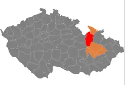 Location in the Olomouc Region within the Czech Republic | |
| Coordinates: 49°58′N 16°58′E | |
| Country | |
| Region | Olomouc |
| Capital | Šumperk |
| Area | |
| • Total | 1,313.06 km2 (506.98 sq mi) |
| Population (2023)[2] | |
| • Total | 119,974 |
| • Density | 91/km2 (240/sq mi) |
| Time zone | UTC+1 (CET) |
| • Summer (DST) | UTC+2 (CEST) |
| Municipalities | 78 |
| * Towns | 8 |
| * Market towns | 0 |
Administrative division
Šumperk District is divided into three administrative districts of municipalities with extended competence: Šumperk, Mohelnice and Zábřeh.
List of municipalities
Towns are marked in bold:
Bludov - Bohdíkov - Bohuslavice - Bohutín - Branná - Bratrušov - Brníčko - Bušín - Chromeč - Dlouhomilov - Dolní Studénky - Drozdov - Dubicko - Hanušovice - Horní Studénky - Hoštejn - Hraběšice - Hrabišín - Hrabová - Hynčina - Jakubovice - Janoušov - Jedlí - Jestřebí - Jindřichov - Kamenná - Klopina - Kolšov - Kopřivná - Kosov - Krchleby - Lesnice - Leština - Libina - Líšnice - Loštice - Loučná nad Desnou - Lukavice - Malá Morava - Maletín - Mírov - Mohelnice - Moravičany - Nemile - Nový Malín - Olšany - Oskava - Palonín - Pavlov - Petrov nad Desnou - Písařov - Police - Postřelmov - Postřelmůvek - Rájec - Rapotín - Rejchartice - Rohle - Rovensko - Ruda nad Moravou - Šléglov - Sobotín - Staré Město - Stavenice - Štíty - Sudkov - Šumperk - Svébohov - Třeština - Úsov - Velké Losiny - Vernířovice - Vikantice - Vikýřovice - Vyšehoří - Zábřeh - Zborov - Zvole
Geography
Šumperk District borders Poland in the north. The landscape is mostly hilly and mountainous, and is divided by several river valleys. The territory extends into eight geomorphological mesoregions: Hanušovice Highlands (most of the territory), Hrubý Jeseník (northeast), Golden Mountains (north), Snieznik Mountains (north), Zábřeh Highlands (southwest), Mohelnice Depression (south), Kłodzko Valley (a small part in the west), Upper Morava Valley (a small part in the east), and Nízký Jeseník (a small part in the east). The highest point of the district and of the entire Olomouc Region is the Praděd mountain in Loučná nad Desnou with an elevation of 1,491 m (4,892 ft). The lowest point is the river bed of the Morava in Moravičany at 243 m (797 ft).
From the total district area of 1,313.1 km2 (507.0 sq mi), agricultural land occupies 556.5 km2 (214.9 sq mi), forests occupy 639.6 km2 (247.0 sq mi), and water area occupies 13.6 km2 (5.3 sq mi). Forests cover 48.7% of the district's area.[1]
The most important river is the Morava, which flows across the district from north to south. Its largest tributary within the district is the Desná. The largest body of water is Moravičanské Lake with an area of 90 ha (220 acres), which is an artificial lake created by flooding a gravel quarry.[3] A notable body of water is also the Dlouhé stráně Reservoir.
The Jeseníky Protected Landscape Area extends into the district in the east, and the Litovelské Pomoraví Protected Landscape Area extends into the district in the south.
Demographics
|
|
| ||||||||||||||||||||||||||||||||||||||||||||||||||||||
| Source: Censuses[4][5] | ||||||||||||||||||||||||||||||||||||||||||||||||||||||||
Most populated municipalities
| Name | Population[2] | Area (km2) |
|---|---|---|
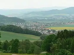
| Šumperk | 25,061 | 28 |
| Zábřeh | 13,434 | 35 |
| Mohelnice | 9,424 | 46 |
| Nový Malín | 3,690 | 27 |
| Rapotín | 3,315 | 14 |
| Libina | 3,283 | 27 |
| Bludov | 3,043 | 17 |
| Loštice | 3,042 | 12 |
| Postřelmov | 2,969 | 10 |
| Hanušovice | 2,952 | 37 |
Economy
The largest employers with headquarters in Šumperk District and at least 500 employees are:[6]
| Economic entity | Location | Number of employees | Main activity |
|---|---|---|---|
| Hella Autotechnik Nova | Mohelnice | 3,000–3,999 | Manufacture of lighting for the automotive industry |
| TDK Electronics | Šumperk | 1,000–1,499 | Manufacture of ferrites for the automotive industry |
| Šumperk Hospital | Šumperk | 1,000–1,499 | Health care |
| OP papírna | Olšany | 500–999 | Manufacture of paper |
| Magna Automotive Stity | Štíty | 500–999 | Metalwork for the automotive industry |
| Dormer Pramet | Šumperk | 500–999 | Manufacture of cutting tools |
| Škoda Pars | Šumperk | 500–999 | Repair and maintenance of rolling stock |
Transport
The D35 motorway (part of the European route E442) from Olomouc ends in Mohelnice and further continues as the I/35 road. The I/44 road separates from it and runs across the district to the north.
Sights
The most important monuments in the district, protected as national cultural monuments, are:[7]
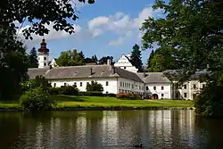
- Velké Losiny Castle
- Paper Mill at Velké Losiny
- Hydroelectric power plant in Třeština
The best-preserved settlements, protected as monument zones, are:[8]
The most visited tourist destinations are the thermal water park in Velké Losiny and Dlouhé stráně Hydro Power Plant.[9]
Notable people
References
- "Land use (as at 31 December)". Public database. Czech Statistical Office. Retrieved 2023-05-18.
- "Population of Municipalities – 1 January 2023". Czech Statistical Office. 2023-05-23.
- "Moravičanské jezero" (in Czech). Olomouc Region. Retrieved 2023-05-22.
- "Historický lexikon obcí České republiky 1869–2011 – Okres Šumperk" (in Czech). Czech Statistical Office. 2015-12-21. pp. 15–16.
- "Population Census 2021: Population by sex". Public Database. Czech Statistical Office. 2021-03-27.
- "Registr ekonomických subjektů". Business Register (in Czech). Czech Statistical Office. Retrieved 2023-05-22.
- "Výsledky vyhledávání: Národní kulturní památky, okres Šumperk". Ústřední seznam kulturních památek (in Czech). National Heritage Institute. Retrieved 2023-05-22.
- "Výsledky vyhledávání: Památkové rezervace, Památkové zóny, okres Šumperk". Ústřední seznam kulturních památek (in Czech). National Heritage Institute. Retrieved 2023-05-22.
- "Turisté mají v České republice nejraději zoologické zahrady, technické památky, koupání a Pražský hrad" (in Czech). CzechTourism. 2022-06-24. Retrieved 2023-05-22.
External links
- Šumperk District – profile on the Czech Statistical Office website