Horní Studénky
Horní Studénky is a municipality and village in Šumperk District in the Olomouc Region of the Czech Republic. It has about 400 inhabitants.
Horní Studénky | |
|---|---|
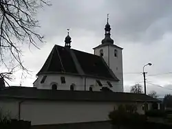 Church of Saint Linhart | |
 Flag  Coat of arms | |
 Horní Studénky Location in the Czech Republic | |
| Coordinates: 49°57′10″N 16°48′43″E | |
| Country | |
| Region | Olomouc |
| District | Šumperk |
| First mentioned | 1353 |
| Area | |
| • Total | 7.24 km2 (2.80 sq mi) |
| Elevation | 515 m (1,690 ft) |
| Population (2023-01-01)[1] | |
| • Total | 354 |
| • Density | 49/km2 (130/sq mi) |
| Time zone | UTC+1 (CET) |
| • Summer (DST) | UTC+2 (CEST) |
| Postal codes | 789 01 |
| Website | www |
Etymology
The name is probably derived from the Czech word studánky (i.e. "springs") and refers to a large number of springs flowing from the slopes around the village. There is also a theory that the name is derived from studený, i.e. "cold".[2]
Geography
Olšany is located about 11 km (7 mi) west of Šumperk and 50 km (31 mi) northwest of Olomouc. It lies in the Zábřeh Highlands. The highest point is the Pustina hill at 626 m (2,054 ft) above sea level. The Nemilka brook originates here and flows through the municipality.
History
The first written mention of Horní Studénky is from 1353.[2]
Sights
The main landmark of Horní Studénky is the Church of Saint Linhart. The original church was built shortly after the village was founded. The current building dates from 1666.[2]
References
- "Population of Municipalities – 1 January 2023". Czech Statistical Office. 2023-05-23.
- "Historie v datech" (in Czech). Obec Horní Studénky. Retrieved 2022-10-08.