Puget lowland forests
Puget lowland forests is a temperate coniferous forest ecoregion the Pacific coast of North America, as defined by the World Wildlife Fund (WWF) categorization system.
| Puget Lowland Forests | |
|---|---|
.jpg.webp) Lowland forest of Stanley Park, Vancouver | |
 | |
| Ecology | |
| Realm | Nearctic |
| Biome | Temperate coniferous forests |
| Borders | |
| Bird species | 195[1] |
| Mammal species | 68[1] |
| Geography | |
| Area | 22,533 km2 (8,700 sq mi) |
| Countries | |
| States | |
| Conservation | |
| Conservation status | Critical/Endangered |
| Habitat loss | 41%[1] |
| Protected | 5.91%[1] |
Setting
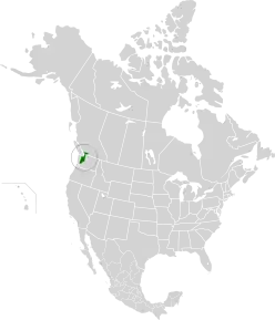
The WWF defines the ecoregion as inhabiting mainland coasts and islands the Georgia Depression, a glacially depressed area dominated by the Salish Sea and numerous inflowing rivers. This differs from the Strait of Georgia/Puget Lowland ecoregion defined by the CEC in that it explicitly excludes the lowlands along the east coast of Vancouver Island. The WWF considers these lowlands a part of the neighbouring Central Pacific coastal forests ecoregion.
The landscape features glacially striated tablelands and rolling hills underlain by sedimentary rocks. The majority of soils in the depression are formed from glacial till, glacial outwash, and Lacustrine deposits.[2] Elevations range from sea level to 460 m (1,509 ft), seldom exceeding 160 m (525 ft).
Climate
The ecoregion has a predominantly Mediterranean climate (Köppen Csb) with fresh, dry, sunny summers and cool winters with moderate precipitation and plentiful cloud cover. Further inland it gradually transitions into an Oceanic climate (Köppen Cfb) with slightly milder, wetter summers. The mean annual temperature is 9 °C (48.2 °F), the mean summer temperature is 15 °C (59 °F), and the mean winter temperature is 3.5 °C (38.3 °F). Annual precipitation averages between 800 and 900 mm (31.5 to 35.4 in), but may be as high as 1,530 mm (60.2 in).
Ecology
Flora

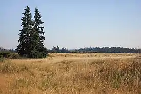
Before European settlement, the Georgia Depression was dominated by dense coniferous forests of Douglas fir, Western Hemlock, Western Redcedar, shore pine, and western white pine.[3] The ecoregion was also home to extensive coastal wetlands and peat bog ecosystems scattered about in poorly drained areas. The lowlands south of Puget Sound were home to an extensive region of prairies.[4] These ecosystems have since been greatly reduced in size due to the repurposing of these lands for agriculture, grazing, industry, and urban development.
Fauna
Mammals that inhabit this ecoregion include black-tailed deer, coyote, raccoon, mink, sea otter, harbour seal, red fox, and the introduced Virginia opossum. Birds represent the majority of resident species, including cooper’s hawk, bald eagle, turkey vulture, owl, blue grouse, waterfowl, and numerous passerine species.
Threats and preservation
Development
This ecoregion lies within the most densely populated area of British Columbia and Washington, including the metropolitan areas of Vancouver and Seattle. Consequently, only 5% of the original lowland forest habitat within the region remains, and over 90% of these remaining areas have been heavily altered from their natural state. Most exist as tree farms, city parks, or as small state/provincial parks geographically isolated from one another.
Climate change
Sea-level rise threatens to permanently flood large swaths of coastal wetland and lowland forest. Regions at highest risk include the Fraser Lowland and Skagit Valley.[5][6]
Preservation
The opportunity exists to use local conservation easements to protect remaining riparian and wetland areas, restore a portion of the old-growth forests, and provide connections to adjacent ecoregions. The best candidates for conservation include the establishment of more forest connections between the forests of the Olympic Peninsula and Cascade Mountains just south of Olympia and the protection of Burns Bog within Metro Vancouver.
Protected areas
Some protected areas of this ecoregion include:
References
- "The Atlas of Global Conservation". The Nature Conservancy. Archived from the original on 2012-03-05. Retrieved 2020-08-18.
- Parks Canada Agency, Government of Canada (2018-03-22). "Environment - Gulf Islands National Park Reserve". www.pc.gc.ca. Retrieved 2020-08-24.
- ""Lower Mainland Ecoregion": Narrative Descriptions of Terrestrial Ecozones and Ecoregions of Canada (#196)". Environment Canada. Archived from the original on January 27, 2007. Retrieved December 4, 2009.
- "The South Puget Sound Prairies: A Unique and Imperiled Landscape - The South Puget Sound Prairies // LandScope America". www.landscope.org. Retrieved 2020-08-24.
- "Delta-RAC Sea Level Rise Adaptation Visioning Study Policy Report" (PDF). fraserbasin.bc.ca. 2014. Retrieved 23 August 2020.
- Burnside, Jeff (2013-09-25). "Rising sea levels, storms could devastate Washington towns". KOMO. Retrieved 2020-08-24.
External links
- "Puget lowland forests". Terrestrial Ecoregions. World Wildlife Fund.
