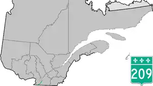
Quebec Route 209
Route 209 is a provincial highway located in the Montérégie region of Quebec south of Montreal. The route runs from the Canada-United States border in Franklin and ends at the Saint-Constant/Sainte-Catherine limit, south of Montreal at the junction of Route 132. South of the US border it continues as New York State Route 189 in Clinton, New York. This road serves as an alternative route to Route 138 (towards Montreal) and the southwestern suburbs) which is a parallel route to Route 209 located roughly 10 kilometers west of it. It also provides the main link to Saint-Rémi, the largest city in the Jardins-de-Napierville MRC.
Route 209 | ||||
|---|---|---|---|---|
 | ||||
| Route information | ||||
| Maintained by Transports Québec | ||||
| Length | 58.9 km[1] (36.6 mi) | |||
| Major junctions | ||||
| South end | ||||
| North end | ||||
| Location | ||||
| Country | Canada | |||
| Province | Quebec | |||
| Highway system | ||||
| ||||

Municipalities along Route 209
 Route 209 south end at the Canada-US Border.
 Église street near junction with route 209 in Saint-Rémi.
Major intersections
| RCM | Location | km | mi | Destinations | Notes |
|---|---|---|---|---|---|
| Le Haut-Saint-Laurent | Franklin | 0.0 | 0.0 | Continuation into New York | |
| Churubusco–Franklin Centre Border Crossing | No northbound access from the U.S. to Canada | ||||
| 4.5 | 2.8 | ||||
| 8.5 | 5.3 | ||||
| Saint-Chrysostome | 20.3 | 12.6 | |||
| Les Jardins-de-Napierville | Sainte-Clotilde | 32.2 | 20.0 | ||
| Saint-Rémi | 43.8 | 27.2 | |||
| Roussillon | Sainte-Catherine | 58.9 | 36.6 | ||
| 1.000 mi = 1.609 km; 1.000 km = 0.621 mi | |||||
See also
References
- Ministère des transports, "Distances routières", page 81, Les Publications du Québec, 2005
This article is issued from Wikipedia. The text is licensed under Creative Commons - Attribution - Sharealike. Additional terms may apply for the media files.