Ratières
Ratières (French pronunciation: [ʁatjɛʁ]) is a commune in the Drôme department in southeastern France.
Ratières | |
|---|---|
 A view within the village of Ratières | |
Location of Ratières | |
 Ratières  Ratières | |
| Coordinates: 45°10′57″N 4°58′08″E | |
| Country | France |
| Region | Auvergne-Rhône-Alpes |
| Department | Drôme |
| Arrondissement | Valence |
| Canton | Drôme des collines |
| Intercommunality | Porte de DrômArdèche |
| Government | |
| • Mayor (2020–2026) | David Bouvier[1] |
| Area 1 | 9.01 km2 (3.48 sq mi) |
| Population | 269 |
| • Density | 30/km2 (77/sq mi) |
| Time zone | UTC+01:00 (CET) |
| • Summer (DST) | UTC+02:00 (CEST) |
| INSEE/Postal code | 26259 /26330 |
| Elevation | 232–449 m (761–1,473 ft) |
| 1 French Land Register data, which excludes lakes, ponds, glaciers > 1 km2 (0.386 sq mi or 247 acres) and river estuaries. | |
Population
| Year | Pop. | ±% |
|---|---|---|
| 1911 | 314 | — |
| 1962 | 217 | −30.9% |
| 1968 | 222 | +2.3% |
| 1975 | 191 | −14.0% |
| 1982 | 182 | −4.7% |
| 1990 | 206 | +13.2% |
| 1999 | 255 | +23.8% |
| 2008 | 274 | +7.5% |
Sights
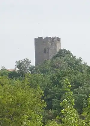
Tour de Ratières
- The Tour de Ratières is the 14th keep of a castle. Extensive modern gardens designed by Paolo Tonini are in the grounds.
See also
References
- "Répertoire national des élus: les maires". data.gouv.fr, Plateforme ouverte des données publiques françaises (in French). 2 December 2020.
- "Populations légales 2020". The National Institute of Statistics and Economic Studies. 29 December 2022.
Wikimedia Commons has media related to Ratières.
This article is issued from Wikipedia. The text is licensed under Creative Commons - Attribution - Sharealike. Additional terms may apply for the media files.