Rabati Malik
Rabati Malik, also called Ribat-i Malik, is a caravanserai ruin located on the M37 road from Samarkand to Bukhara about a kilometer west of the edge of Malik, Navoiy Province, Uzbekistan. It was constructed along the Silk Road according to the orders of Karakhanid Shams al-Mulk Nasr, son of Tamgachkhan Ibragim, who ruled in Samarkand from 1068 until 1080.
| Raboti Malik | |
|---|---|
Raboti Malik, Shoh raboti | |
.jpg.webp) | |
| General information | |
| Town or city | Karmana District |
| Country | Uzbekistan |
| Construction started | 1068 |
| Owner | Uzbek government |
Site description

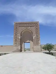
The portal of the caravanserai – which is one of the most ancient places among the Central Asia portals – peshtak with the central lancet arch of the niche in which there is a rectangular doorway. The arch concludes with a П-shaped frame, executed from carved terracotta in the form of eight final stars connected with each other, limited by intertwining tapes. The ring is decorated by Arabic inscriptions. On overhanging walls, under the layers of repair plaster, the remains of ancient ganched plasters with figures of vegetative characters are traced.
The portal, as well as all caravanserais, has been laid out from adobe brick with the subsequent facing baked bricks measuring 25х 25 х 4 cm in size, on the ganched solution. The average height of the kept walls ranges from 0,4 up to 0,7 m. The caravanserai occupies – 8277 sq. m.[1]
History
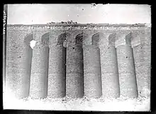
Rabat-i Mâlik holds a special place in the history of Iranian architecture. This is due to its impressive façade treatment of ornamental embedded cylindrical columns on the walls flanking the main entrance portal. The large, brick semi-columns were connected at the top by arches—a rare façade decor found on the flanking walls of the 2500-year-old Apadana palace at Persepolis, and at such Parthian and Sasanian monuments such as Firuzabad. The only other building of the Islamic period that contains such a treatment, is found on the minaret of Jarkurgan/Dzharkurgan in the neighbouring Surkhondaryo province of Uzbekistan.
Regrettably, except for the entrance portal that was badly damaged, the earthquake of 1968 totally demolished what was left of the rest of the rabat, including the landmark flanking walls with the semi-column decorations. Luckily, detailed monochrome photographs are available of the old flanking walls to document this landmark building and help with accurate restorations in the future.
World Heritage Status
This site was added to the UNESCO World Heritage Tentative List on 18 January 2008, in the Cultural category.
History of research
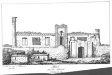
In 1841-42, the Caravanserai Rabati Malik was explored by an expedition led by engineers Butenev and Bogoslovsky. The expedition also began to write the first scientific books dedicated to this structure. The first and relatively comprehensive description of the building was compiled by the naturalist Alexander Leman.[2] Leman also created sketches of the external appearance of the building. From these sketches, it is evident that the southern facade is well-preserved and framed by an external wall with an arched entrance.[3] Another participant in the expedition was the orientalist Nikolay Khanikov, who provided a brief description of the building.[2]
During the Soviet period, Rabati Malik underwent comprehensive research. The studies conducted by Ivan Umnyakov and Boris Zasipkin. Umnyakov's research includes a series of historical details about Rabati Malik and highlights the challenges in studying the architecture of the Khorezmshah era. Zasipkin's research is dedicated to the archaeology of art and the key elements of Rabati Malik's structure.[2]
The work of these two scholars subsequently became the basis for many other scientific studies, including those by Boris Denike and Boris Veimar, as well as professors L. Voronin, V. Voronin, and T. Stramsov.[2]
In the latter half of the 20th century, an archaeological expedition was carried out, during which the first information about the internal infrastructure and composition of Rabati Malik was obtained.[4] Engineer Krasilnikov conducted measurements that allowed for the determination of proportions and scale. According to Zasipkin's measurements, the width of the arched is 12.03 meters, and the height is 12 meters. The width of the entrance arch is 5.73 meters, the thickness is 1.43 meters, and the wall height is approximately 12 meters.[5]
For a long time, it was believed that Rabati Malik was built in 1078-79, as indicated by Bartold. However, in 1951, A. Semyonov found evidence that another caravanserai was constructed in the 11th century near Samarkand. This fact casts doubt on the dating of the construction of Rabati Malik.[3]
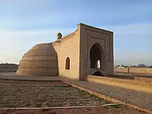
On the territory of Rabati Malik, archaeological investigations were conducted in 1937-1940, 1973-1977, 1997, 1999, and 2001.[6] As a result of these studies, information about the history of Rabati Malik, the time of its construction, architectural features of the internal parts, and numerous artifacts (ceramics, metal, and decorations, including valuables and coins from various years) were found. Beneath the surface layer of the earth, the remains of square-shaped walls, typical of palace structures, were discovered, along with numerous fragments of schematic drawings. The residential area was in the north, adorned with drawings, while the south held trading spaces.[4] Water was supplied to Rabati Malik through tunnels starting from Sardoba.[6]
Deterioration period
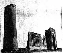
At the end of the 19th century and into the 20th century, the Rabati Malik caravanserais continued to deteriorate. In 1875, one of the two minarets on the southern facade collapsed, leaving only the western minaret standing. According to findings from 1911, the central dome with the dome was also in a state of disrepair. In 1924, the right side of the southern facade collapsed.[3]
In the 1950s of the 20th century, the central part of Rabati Malik caravanserai and its cistern was demolished to make way for an asphalt road (M-37), leading to the loss of the urban fabric of the area. After the road was built, the local residents began using the fallen stones from the southern wall as building materials.[5]
See also
- Ribat, Arabic word for Early Muslim frontier fort, later caravansary and Sufi retreat
References
- "Rabati Malik Caravanserai".
- Alexandrovich, Nielsen (1956). Нильсен В.А. Монументальная архитектура Бухарского оазиса XI-XII вв. К вопросу о возникновении средневековой архитектуры в Средней Азии. Ташкент, 1956 [(Nielsen V.A. Monumental architecture of the Bukhara oasis of the 11th-12th centuries. On the issue of the emergence of medieval architecture in Central Asia. Tashkent, 1956)] (in Russian). Tashkent: Academy of Sciences of the Uzbek.
- Khmelnitsky, Sergey (1992). Между арабами и тюрками. Архитектура Средней Азии IX — X вв [(Architecture of Central Asia IX – X centuries)] (in Russian). Berlin-Riga: Continent Ltd.
- Borisovna Nemtseva, Nina (2009). Рабат-и Малик, ХI - начало ХVШ вв (археологические исследования) [(Rabat-i Malik, XI - early XVIII centuries (archaeological research)] (in Russian). Tashkent: Institut Français d’Études sur l’Asie Centrale.
- Borisovna Nemtseva, Nina (2009). Рабат-и Малик, ХI - начало ХVШ вв (археологические исследования) [(Rabat-i Malik, XI - early XVIII centuries (archaeological research)] (in Russian). Tashkent: Institut Français d’Études sur l’Asie Centrale.
- Hotamov; Halilov (1995). Yillar sadosi [(The sound of years)] (in Uzbek). Tashkent: Adolat.
.jpg.webp)