Riceville, Montana
Riceville is an unincorporated community and census-designated place (CDP) in Cascade County, Montana, United States. It is in the southeastern part of the county, along U.S. Route 89 in the valley of Belt Creek, at the northern edge of the Little Belt Mountains. Via US-89, Riceville is 13 miles (21 km) south of Belt, 34 miles (55 km) southeast of Great Falls, and 64 miles (103 km) north of White Sulphur Springs.
Riceville, Montana | |
|---|---|
 Riceville  Riceville | |
| Coordinates: 47°13′4″N 110°55′50″W | |
| Country | United States |
| State | Montana |
| County | Cascade |
| Area | |
| • Total | 0.88 sq mi (2.29 km2) |
| • Land | 0.88 sq mi (2.29 km2) |
| • Water | 0.00 sq mi (0.00 km2) |
| Elevation | 4,125 ft (1,257 m) |
| Population (2020) | |
| • Total | 36 |
| • Density | 40.82/sq mi (15.75/km2) |
| Time zone | UTC-7 (Mountain (MST)) |
| • Summer (DST) | UTC-6 (MDT) |
| ZIP Code | 59412 (Belt) |
| Area code | 406 |
| FIPS code | 30-62245 |
| GNIS feature ID | 2804698[2] |
Riceville was first listed as a CDP prior to the 2020 census.[2]
References
- "ArcGIS REST Services Directory". United States Census Bureau. Retrieved September 5, 2022.
- "Riceville Census Designated Place". Geographic Names Information System. United States Geological Survey, United States Department of the Interior.
- "Census of Population and Housing". Census.gov. Retrieved June 4, 2016.
Municipalities and communities of Cascade County, Montana, United States | ||
|---|---|---|
| City | 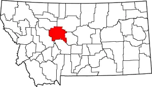 Cascade County map | |
| Towns | ||
| CDPs | ||
| Indian reservation | ||
This article is issued from Wikipedia. The text is licensed under Creative Commons - Attribution - Sharealike. Additional terms may apply for the media files.