Richmond, New Zealand
Richmond (Māori: Waimea) is a town and the seat of the Tasman District Council in New Zealand. It lies 13 kilometres (8 mi) south of Nelson in the South Island, close to the southern extremity of Tasman Bay. The town, first settled by Europeans in 1842,[3] was named in 1854 after the town of Richmond on Thames near London. The town has an estimated population of 19,200 as of June 2023.[2]
Richmond
Waimea | |
|---|---|
Town | |
![Queen Street, the main street of Richmond in New Zealand (as of 2011[update])](../I/Richmond_NZ_Main_Street_001.JPG.webp) Queen Street, the main street of Richmond in New Zealand (as of 2011) | |
| Coordinates: 41°20′S 173°11′E | |
| Country | New Zealand |
| Territorial authority | Tasman |
| Ward | Richmond Ward |
| Founded | 1854 |
| Electorates | |
| Government | |
| • Territorial Authority | Tasman District Council |
| • Mayor of Tasman | Tim King |
| • Nelson MP | Blair Cameron |
| • Te Tai Tonga MP | Tākuta Ferris |
| Area | |
| • Total | 17.37 km2 (6.71 sq mi) |
| Population (June 2023)[2] | |
| • Total | 19,200 |
| • Density | 1,100/km2 (2,900/sq mi) |
| Postcode(s) | 7020 |
| Area code | 03 |
Although most of Richmond lies outside the boundaries of Nelson City and the town is considered a separate urban area, Richmond is part of the wider Nelson metropolitan area along with nearby Brightwater, Hope, Māpua and Wakefield.[4] The two unitary authorities (Nelson and Tasman) co-operate for tourism-marketing purposes via "Latitude Nelson". As of 2020 Richmond forms part of the Nelson parliamentary electorate.
History
During the period 1853 to 1876, the Richmond urban area was administered as part of Nelson Province. With the Abolition of Provinces Act 1876, Waimea County was created, effective in January 1877. Richmond was included in the Waimea County boundaries, and served as the administrative headquarters of the county.
In 1891, the administrative authority for the urban area of Richmond was transferred from Waimea County to the Richmond Borough Council.[5]
Richmond Borough existed until the 1989 local government reforms, when the Tasman District was formed through the amalgamation of the Richmond Borough, Golden Bay County, Murchison County and Waimea County administrative areas.[6]
Demographics
The Richmond urban area, as defined by Statistics New Zealand, covers 17.37 km2 (6.71 sq mi) and incorporates nine statistical areas. The Daelyn statistical area, covering 1.47 km2 (0.57 sq mi), is the sole area of Richmond within Nelson City; the remaining eight areas are within Tasman District.[1] It had an estimated population of 19,200 as of June 2023,[2] with a population density of 1,105 people per km2.
| Year | Pop. | ±% p.a. |
|---|---|---|
| 2006 | 12,420 | — |
| 2013 | 13,383 | +1.07% |
| 2018 | 15,279 | +2.69% |
| Source: [7] | ||
Richmond had a population of 15,279 at the 2018 New Zealand census, an increase of 1,896 people (14.2%) since the 2013 census, and an increase of 2,859 people (23.0%) since the 2006 census. There were 5,739 households, comprising 7,338 males and 7,944 females, giving a sex ratio of 0.92 males per female, with 2,805 people (18.4%) aged under 15 years, 2,442 (16.0%) aged 15 to 29, 6,456 (42.3%) aged 30 to 64, and 3,579 (23.4%) aged 65 or older.
Ethnicities were 93.0% European/Pākehā, 6.9% Māori, 1.2% Pasifika, 3.5% Asian, and 1.8% other ethnicities. People may identify with more than one ethnicity.
The percentage of people born overseas was 16.7, compared with 27.1% nationally.
Although some people chose not to answer the census's question about religious affiliation, 53.8% had no religion, 35.9% were Christian, 0.1% had Māori religious beliefs, 0.3% were Hindu, 0.3% were Muslim, 0.9% were Buddhist and 1.2% had other religions.
Of those at least 15 years old, 2,007 (16.1%) people had a bachelor's or higher degree, and 2,664 (21.4%) people had no formal qualifications. 1,824 people (14.6%) earned over $70,000 compared to 17.2% nationally. The employment status of those at least 15 was that 5,499 (44.1%) people were employed full-time, 1,968 (15.8%) were part-time, and 351 (2.8%) were unemployed.[7]
| Name | Area (km2) | Population | Density (per km2) | Households | Median age | Median income |
|---|---|---|---|---|---|---|
| Richmond West (Tasman District) | 6.46 | 924 | 143 | 321 | 56.4 years | $23,900[8] |
| Richmond Central (Tasman District) | 1.15 | 1,848 | 1,607 | 732 | 38.9 years | $26,800[9] |
| Ben Cooper Park | 0.92 | 2,355 | 2,560 | 951 | 41.4 years | $29,300[10] |
| Richmond South (Tasman District) | 2.51 | 618 | 246 | 210 | 45.0 years | $36,900[11] |
| Wilkes Park | 0.88 | 2,304 | 2,618 | 867 | 47.8 years | $30,300[12] |
| Templemore | 1.43 | 2,004 | 1,401 | 687 | 49.5 years | $29,100[13] |
| Easby Park | 1.13 | 2,754 | 2,437 | 1,005 | 39.2 years | $30,600[14] |
| Fairose | 1.42 | 1,620 | 1,141 | 678 | 55.5 years | $30,700[15] |
| Daelyn | 1.47 | 852 | 580 | 288 | 43.9 years | $31,700[16] |
| New Zealand | 37.4 years | $31,800 |
Economy
Richmond Mall
Richmond Mall opened in 1973.[17] It covers an area of 23,142 m² and has 800 carparks and 70 stores, including Farmers, Pak'nSave and FreshChoice.[18]
Education
General public schools
Waimea College is a co-educational state secondary school for Year 9 to 13 students,[19][20] with a roll of 1576 as of April 2023.[21]
Waimea Intermediate is a co-educational state intermediate school for Year 7 to 8 students,[22][23] with a roll of 655.[24]
There are two state primary schools for Year 1 to 6 students:
In addition, there is a primary school at Appleby
Specialist schools
Salisbury School is a state school for Year 3 to 10 girls with complex learning needs,[30] with a roll of 15.[31] It was established on 1916, on a homestead established by William McRae in 1850.[32]
Te Kura Kaupapa Māori o Tuia Te Matangi is a co-educational state Māori language immersion school for Year 1 to 13 students,[33][34] with a roll of 54.[35]
Gallery
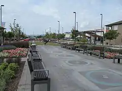 Sundial Square in central Richmond, New Zealand. The sundial in view was unveiled in 1994 and weighs 800 kilograms.
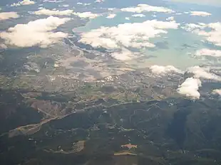 Richmond seen from the air, showing its close connection to Nelson at the right
See also
References
- "ArcGIS Web Application". statsnz.maps.arcgis.com. Retrieved 25 July 2021.
- "Subnational population estimates (RC, SA2), by age and sex, at 30 June 1996-2023 (2023 boundaries)". Statistics New Zealand. Retrieved 25 October 2023. (regional councils); "Subnational population estimates (TA, SA2), by age and sex, at 30 June 1996-2023 (2023 boundaries)". Statistics New Zealand. Retrieved 25 October 2023. (territorial authorities); "Subnational population estimates (urban rural), by age and sex, at 30 June 1996-2023 (2023 boundaries)". Statistics New Zealand. Retrieved 25 October 2023. (urban areas)
- "Early Richmond". Theprow.org.nz. Retrieved 6 November 2018.
- "Functional urban areas – methodology and classification | Stats NZ". www.stats.govt.nz. Retrieved 23 June 2021.
- Fraser, Bryce; McLauchlan, Gordon (1986). The New Zealand Book of Events. Auckland: Methuen Publishing. ISBN 978-0474001239.
- Walrond, Carl (3 August 2015). "Nelson region - Government". Te Ara - the Encyclopedia of New Zealand. New Zealand Ministry for Culture and Heritage. Retrieved 5 November 2018.
- "Statistical area 1 dataset for 2018 Census". Statistics New Zealand. March 2020. Richmond West (Tasman District) (302400), Richmond Central (Tasman District) (302800), Ben Cooper Park (302900), Richmond South (Tasman District) (303000), Wilkes Park (303100), Templemore (303200), Easby Park (303300), Fairose (303400) and Daelyn (306100).
- 2018 Census place summary: Richmond West (Tasman District)
- 2018 Census place summary: Richmond Central (Tasman District)
- 2018 Census place summary: Ben Cooper Park
- 2018 Census place summary: Richmond South (Tasman District)
- 2018 Census place summary: Wilkes Park
- 2018 Census place summary: Templemore
- 2018 Census place summary: Easby Park
- 2018 Census place summary: Fairose
- 2018 Census place summary: Daelyn
- "Richmond Mall to celebrate 40 years". nelsonweekly.co.nz. Nelson Weekly. 25 September 2013.
- "Richmond Mall". tinline.co.nz. Tinline Property.
- "Waimea College Official School Website". waimea.school.nz.
- "Waimea College Ministry of Education School Profile". educationcounts.govt.nz. Ministry of Education.
- "Waimea College Education Review Office Report". ero.govt.nz. Education Review Office.
- "Waimea Intermediate Official School Website". waimeaint.school.nz.
- "Waimea Intermediate Ministry of Education School Profile". educationcounts.govt.nz. Ministry of Education.
- "Waimea Intermediate Education Review Office Report". ero.govt.nz. Education Review Office.
- "Richmond School Ministry of Education School Profile". educationcounts.govt.nz. Ministry of Education.
- "Richmond School Education Review Office Report". ero.govt.nz. Education Review Office.
- "Henley School Official School Website". henley.school.nz.
- "Henley School Ministry of Education School Profile". educationcounts.govt.nz. Ministry of Education.
- "Henley School Education Review Office Report". ero.govt.nz. Education Review Office.
- "Salisbury School Ministry of Education School Profile". educationcounts.govt.nz. Ministry of Education.
- "Salisbury School Education Review Office Report". ero.govt.nz. Education Review Office.
- "Salisbury School Official School Website". salisbury.school.nz.
- "Te Kura Kaupapa Māori o Tuia Te Matangi Official School Website". tuiatematangi.ac.nz.
- "Te Kura Kaupapa Māori o Tuia Te Matangi Ministry of Education School Profile". educationcounts.govt.nz. Ministry of Education.
- "Te Kura Kaupapa Māori o Tuia Te Matangi Education Review Office Report". ero.govt.nz. Education Review Office.
- "Garin College Official School Website". garincollege.ac.nz.
- "Garin College Ministry of Education School Profile". educationcounts.govt.nz. Ministry of Education.
- "Garin College Education Review Office Report". ero.govt.nz. Education Review Office.
- "St Paul's School Ministry of Education School Profile". educationcounts.govt.nz. Ministry of Education.
- "St Paul's School Education Review Office Report". ero.govt.nz. Education Review Office.
External links
 Media related to Richmond, New Zealand at Wikimedia Commons
- Richmond Unlimited