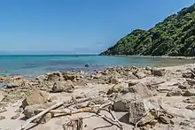
Wainui Bay
Wainui Bay is within Golden Bay, and at the south-eastern end of Golden Bay, in the Tasman Region of the South Island, New Zealand.

Eastern side of Wainui Bay, on the Taupo Point track
Wainui is a Māori language term (wai meaning water, and nui meaning large, expansive) and the umbrella entity for the three local iwi gives a meaning of "where the tidal flow leaves a big expanse of bay empty".[1]
Bordering the Abel Tasman National Park, it is approximately 24 kilometres (15 mi) north-east of Tākaka, the nearest town.[2][3] There are several Department of Conservation walking tracks that start in Wainui Bay, including the Wainui Falls track, the Taupo Point track, and other tracks leading into the Abel Tasman National Park.[4][5][6]
References
Wikimedia Commons has media related to Wainui Bay.
- Mohua place names (photo). Tasman District Library. Retrieved 6 August 2023.
- "Wainui Bay, Tasman – NZ Topo Map". NZ Topo Map. 15 November 2017. Retrieved 10 January 2018.
- "Wainui Falls Track". doc.govt.nz. Retrieved 9 January 2018.
- "Wainui Bay Walks". goldenbayhideaway.co.nz. Retrieved 7 December 2018.
- "NZ Walks Information: Taupo Point Track". nzwalksinfo.co.nz. Retrieved 7 December 2018.
- "Wainui Falls Track". www.doc.govt.nz. Retrieved 7 December 2018.
This article is issued from Wikipedia. The text is licensed under Creative Commons - Attribution - Sharealike. Additional terms may apply for the media files.