Ronchamp coal mines
The Ronchamp Coal Mines were an area of coal mines located in the Vosges and Jura coal mining basins, in eastern France. They covered three municipalities; Ronchamp, Champagney and Magny-Danigon. Operated for more than two centuries, from the mid-eighteenth century until the mid-twentieth century, they have profoundly changed the landscape, the economy and the local population.
Mining began in Ronchamp in the mid-18th century and had developed into a large industry by the late 19th century, employing 1500 people.
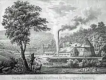
Extraction started in adit before being dug at coal mine Saint Louis in 1810, introducing the first real extraction mine-shaft. The shaft seams sunk more and more, and became deeper until the well, owned by (Civil Society coal Ronchamp), eventually became the deepest mine in France beating the coal mine du Magny (694 meters) in 1878 and the coal mine Arthur de Buyer (1010 meters) in 1900. After the nationalisation of mines in 1946, the shaft and the thermal power station was entrusted to Electricité de France.
After closing in 1958, the mining sites and infrastructures were demolished and workers had to convert to other professions. Later, a museum and two associations were created to preserve the memory of the mining heritage and several sites were redeveloped to become tourist attractions.
The museum looks back at the miner's work, their techniques, tools they used and their social life. A collection of miners lamps are also on display.[1][2]
Geography
Situation
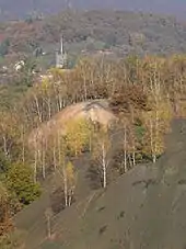
The zone exploited and influenced by the coal mines corresponds to the Ronchamp and Champagney mining basin which is at the heart of the Vosges and Jura coal mining basins, on the eastern part of the French department of the Haute-Saône, in the northern part of the French region of Bourgogne-Franche-Comté, close to Alsace and the industries of Mulhouse. The coal mines are then an essential source of energy for both regions. The Alsatian catchment area is between the towns of Mulhouse, Thann and Cernay.[3]
The concession of Ronchamp, Champagney and Éboulet, where the mines are exploited, has 4503 hectares and includes the communes of Ronchamp, Champagney, Magny-Danigon, Clairegoutte, Andornay, Palante and La Côte (only the first three have coal mines). It is surrounded by the Mourière concession to the northwest, the Saint-Germain concession to the west and the Lomont concession to the south but also by other exploratory mines to the east.
History
Beginning
Coal deposits were discovered in Ronchamp in the mid-18th century. Mining activity was a complementary resource for a population whose main occupation was agriculture. In 1744, two exploration galleries and various surface excavations were dug, but these works were unofficial.[2] In 1749, the lord of Gensanne, owner of mines in Plancher-les-Mines and several mines in Alsace, sent a piece of coal to a laboratory in Besançon for analysis.[2] It was in 1751 that several applicants for exploitation came forward. Among them, two local industrialists: the lord of Gensanne and François Guy, owner of a large forge in Magny-Vernois. In the end, none of them obtained a concession.[4]
Two concessions were finally granted in 1757,[2][5] the concession of the lords of Ronchamp in Ronchamp, granted on September 11, 1757, and the concession of the prince-abbots of Lure in Champagney, granted on April 21, 1757.
The decree of September 24, 1768 granted the barons of Ronchamp and associates the exclusive exploitation, for a period of about thirty years, of all the coal mines that are located within the extent of the barony of Ronchamp. The two concessions became one, and they were operated at common expense by the two concessionaires, who requested a single concession. This was granted by the decree of March 1, 1763.[2]
Mine list
| Digging | Name | Depth | Activity | Function | Other functions |
|---|---|---|---|---|---|
| 1810 | Coal mine Saint-Louis | 135 m | 1823 – 1842 | Extraction | |
| 1815 | Coal mine Henri IV | 61 m | 1816 – 1835 | Extraction | |
| 1822 | Coal mine Samson | 19 m | 1824 | Extraction | |
| 1825 | Coal mine #1 | 164 m | 1827 – 1833 | Extraction | |
| 1825 | Coal mine #2 | 156 m | 1828 – 1833 | Extraction | |
| 1825 | Coal mine #3 | 38 m | 1826 – 1829 | Extraction | |
| 1829 | Coal mine #4 | 45 m | 1830 – 1841 | Extraction | |
| 1830 | Coal mine #5 | 74 m | 1832 | Research | |
| 1832 | Coal mine #6 | 66 m | 1834 – 1836 | Extraction | Ventilation 1839-1850 |
| 1839 | Coal mine #7 | 205 m | 1843 – 1849 | Extraction | Ventilation 1849-1872 |
| 1845 | Coal mine Saint Charles / #8 | 315 m | 1847 – 1895 | Extraction | |
| 1850 | Coal mine Saint Joseph | 453 m | 1855 – 1895 | Extraction | |
| 1851 | Coal mine Notre Dame d'Éboulet | 564 m | 1859 – 1896 | Extraction | Drainage 1896-1958 |
| 1854 | Coal mine Saint Jean | 51 m | 1856 | Research | |
| 1854 | Coal mine Sainte Barbe | 324 m | 1860 – 1872 | Extraction | Ventilation of coal mine Sainte-Pauline |
| 1854 | Coal mine Sainte Pauline | 546 m | 1861 – 1884 | Extraction | |
| 1855 | Coal mine de l'Espérance | 103 m | 1858 | Extraction | |
| 1864 | Coal mine Sainte Marie | 359 m | 1866 – 1869 | Extraction | Ventilation 1869-1958 |
| 1866 | Coal mine Saint Georges | 470 m | 1870 – 1873 | Extraction | |
| 1873 | Coal mine du Magny | 694 m | 1878 – 1958 | Extraction | Service 1916-1928 |
| 1873 | Coal mine du Chanois | 588 m | 1900 – 1951 | Extraction | |
| 1883 | Coal mine du Tonnet / #9 | 574 m | 1886 – 1888 | Extraction | |
| 1884 | Coal mine #10 | 247 m | 1886 – 1896 | Ventilation | |
| 1892 | Coal mine Arthur de Buyer / #11 | 1 010 m | 1900 – 1954 | Extraction | |
| 1949 | Coal mine de l'Étançon / #13 bis | 44 m | 1950 – 1958 | Extraction |
Picture
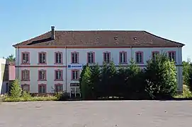 The offices of the Coal mine of Ronchamp (2012).
.JPG.webp)
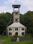 Coal mine Sainte-Marie in 2007.
References
- "Ronchamp et son association les amis du musée de la mine de Ronchamp". Les Amis du Musée de la Mine. Retrieved 2023-10-22.
- "Le bassin houiller de Ronchamp" [Ronchamp Coal Basin]. Les Amis du Musée de la Mine. Retrieved 2023-10-22.
- Godard 2012, pp. 6–7.
- Parietti, Jean-Jacques (2002). Les houillères de Ronchamp. Vesoul: Éd. comtoises. p. 87. ISBN 978-2-914425-08-7.
- Trautmann, E. Auteur du texte (1885–1886). Bassin houiller de Ronchamp / par E. Trautmann,... ; Ministère des Travaux publics, Service des topographies souterraines.
Sources
- Godard, Michel (2012). Enjeux et impacts de l'exploitation minière du bassin houiller de Ronchamp (1810-1870) [Issues and Impacts of Mining in the Ronchamp Coalfield (1810-1870)] (PDF) (in French). University of Technology of Belfort-Montbéliard.
See also
- Notre-Dame Mine Shaft
- Arthur de Buyer Coal Mine
- Sainte Marie Coal Mine
- Sainte-Barbe Coal Mine
- Hamlet of La Houillère