Borough of Rugby
The Borough of Rugby is a local government district with borough status in eastern Warwickshire, England. The borough comprises the town of Rugby where the council has its headquarters, and the rural areas surrounding the town. The borough has a population of 114,400 (2021). Of which, 78,125 live in Rugby itself and the remainder living in the surrounding areas. Aside from Rugby itself, more notable settlements include Binley Woods, Brinklow, Clifton-upon-Dunsmore, Dunchurch, Long Lawford, Monks Kirby, Ryton-on-Dunsmore, Stretton-on-Dunsmore and Wolston, and the new large development of Houlton.
Borough of Rugby | |
|---|---|
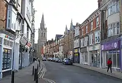 Rugby, the largest settlement and administrative centre of the borough | |
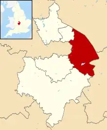 Shown within Warwickshire | |
| Sovereign state | United Kingdom |
| Constituent country | England |
| Region | West Midlands |
| Administrative county | Warwickshire |
| Admin. HQ | Rugby |
| Government | |
| • Type | Non-metropolitan borough |
| • Leadership: | Leader and cabinet |
| • MPs: | Mark Pawsey (Rugby) Jeremy Wright (Kenilworth and Southam) |
| Area | |
| • Total | 135.6 sq mi (351.1 km2) |
| • Rank | 101st |
| Population (2021) | |
| • Total | 114,829 |
| • Rank | Ranked 210th |
| • Density | 850/sq mi (330/km2) |
| Time zone | UTC+0 (Greenwich Mean Time) |
| • Summer (DST) | UTC+1 (British Summer Time) |
| ONS code | 44UD (ONS) E07000220 (GSS) |
| Ethnicity | 90.5% White (84.1% White British) 5.2% Asian 2.0% Mixed Race 2.0% Black British 0.3% Other [1] |
| Website | rugby.gov.uk |
The borough stretches from Coventry to the west, to the borders with Northamptonshire and Leicestershire to the east. It borders the Warwickshire districts of Warwick to the south-west, Stratford to the south, and Nuneaton and Bedworth to the north-west. It includes a large area of the West Midlands Green Belt in the mostly rural area between Rugby and Coventry.
Between 2011 and 2021, the population of Rugby borough saw a 14.3% increase from around 100,100 in to 114,400, meaning it has had the largest percentage increase in population of any local authority area in the West Midlands region since 2011.[2]
History
The present borough was created on 1 April 1974 by the Local Government Act 1972. It was created by a merger of the municipal borough of Rugby (which covered the town of Rugby) and the Rugby Rural District.
The town of Rugby gained the status of an urban district in 1894.[3] At the same time the Rugby Rural District was created covering the surrounding countryside.[4] The town and rural district had separate councils, both based in Rugby. In 1932, Rugby's status was upgraded to that of a municipal borough, and its boundaries expanded to include most of Bilton, Brownsover, Hillmorton and Newbold-on-Avon.[3]
Rugby Borough Council
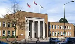
The headquarters of Rugby Borough Council is based at Rugby Town Hall on Evreux Way in the town centre. The last elections to the council were held in 2023.
Political composition
One-third of council seats are elected every year, with one year without an election.
| Year | Labour | Conservatives | Liberal Democrats | Others |
|---|---|---|---|---|
| 2023 | 12 | 21 | 9 | 0 |
| 2022 | 10 | 23 | 9 | 0 |
| 2018 | 9 | 24 | 9 | 0 |
| 2016 | 9 | 21 | 9 | 3 |
| 2011 | 11 | 29 | 8 | 0 |
| 2010 | 11 | 28 | 9 | 0 |
| 2007 | 11 | 27 | 10 | 0 |
| 2006 | 13 | 24 | 10 | 1 |
| 2004 | 14 | 21 | 10 | 3 |
| 2003 | 16 | 18 | 10 | 4 |
| 2002 | 16 | 18 | 10 | 4 |
| 2000 | 18 | 14 | 9 | 7 |
| 1999 | 22 | 11 | 7 | 8 |
| 1998 | 22 | 12 | 5 | 9 |
Political control
Since 1974, Rugby Borough Council has spent the majority of its time under no overall control interspersed with periods of Conservative control. Political control of the council since 1974 has been held by the following parties:[5]
| Party in control | Years | |
|---|---|---|
| No overall control | 1974–1976 | |
| Conservative | 1976–1979 | |
| No overall control | 1979–1987 | |
| Conservative | 1987–1990 | |
| No overall control | 1990–2007 | |
| Conservative | 2007–2016 | |
| No overall control | 2016–2018 | |
| Conservative | 2018–2023 | |
| No overall control | 2023–present | |
Sub-divisions
Wards
The borough is divided into 16 wards, with 42 councillors.[6][7] For a list of wards in Rugby borough see List of wards in Rugby borough by population.
Parishes
The borough of Rugby has 41 civil parishes mainly covering the rural areas of the borough. Rugby town is an unparished area and so does not have a separate town council.[8]
Here is a list of parishes in the borough, some of which contain several settlements. Where a parish contains more than one settlement these are listed in brackets:
- Ansty,
- Binley Woods, Birdingbury, Bourton and Draycote, Brandon and Bretford, Brinklow, Burton Hastings
- Cawston, Church Lawford, Churchover, Clifton-upon-Dunsmore, Combe Fields, Copston Magna, Cosford,
- Dunchurch (incl: Toft)
- Easenhall
- Frankton,
- Grandborough
- Harborough Magna
- King's Newnham
- Leamington Hastings (incl: Broadwell, Hill & Kites Hardwick), Little Lawford, Long Lawford
- Marton, Monks Kirby,
- Newton and Biggin
- Pailton, Princethorpe
- Ryton-on-Dunsmore
- Shilton and Barnacle, Stretton Baskerville, Stretton-on-Dunsmore, Stretton-under-Fosse
- Thurlaston,
- Wibtoft, Willey, Willoughby, Withybrook, Wolfhampcote (incl: Flecknoe & Sawbridge), Wolston, Wolvey.
References
- "Key statistics". www.ons.gov.uk. 2011. Retrieved 4 January 2020.
- "How the population changed in Rugby: Census 2021". Office for National Statistics. Retrieved 10 November 2022.
- "Rugby MB/UD Local Government District". Vision of Britain. Retrieved 20 October 2018.
- "Rugby RD Local Government District". Vision of Britain. Retrieved 20 October 2018.
- "Compositions calculator". The Elections Centre. 4 March 2016. Retrieved 10 August 2022.
- "RUGBY District Wards". City Population. Retrieved 20 October 2018.
- "The Council". Rugby Borough Council. Retrieved 20 October 2018.
- "RUGBY District Parishes". City Population. Retrieved 20 October 2018.
| Boroughs or districts | |
|---|---|
| Major settlements (cities in italics) | |
| Rivers | |
| Canals | |
| Topics | |
