Sabotsy Anjiro
Sabotsy Anjiro is a rural municipality that is composed by two towns (Sabotsy & Anjiro) in Madagascar. It belongs to the district of Moramanga, which is a part of Alaotra-Mangoro Region. The population of the commune was estimated to be 17,418 in 2018 and lies approximately 80 km west of Antananarivo, along the National Road 2 to Toamasina.
Sabotsy Anjiro | |
|---|---|
 Sabotsy Anjiro Location in Madagascar | |
| Coordinates: 18°53′S 47°58′E | |
| Country | |
| Region | Alaotra-Mangoro |
| District | Moramanga |
| Elevation | 983 m (3,225 ft) |
| Population (2018) | |
| • Total | 17,418 |
| Time zone | UTC3 (EAT) |
| postal code | 514 |
Primary and junior level secondary education are available in town. The majority 80% of the population of the commune are farmers. The most important crop is rice, while other important products are beans and cassava. Services provide employment for 20% of the population.[2]
Both towns, Sabotsy and Anjiro have a train station along the Antananarivo East coast line. They lie at the Mangoro River.
Roads
The municipality of Sabotsy Anjiro is crossed by the National Road 2.
References
- Estimated based on DEM data from Shuttle Radar Topography Mission
- "ILO census data". Cornell University. 2002. Retrieved 2008-03-24.
Capital: Ambatondrazaka | ||
| Ambatondrazaka (21) | 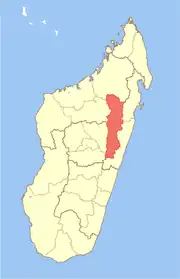 | |
| Amparafaravola (21) | ||
| Andilamena (8) | ||
| Anosibe An'ala (11) | ||
| Moramanga (22) | ||
5 districts; 82 communes | ||