Sagua la Chica River
Sagua la Chica River is a river of northern Cuba, that flows through Villa Clara Province. Arising in the hills of Placetas, it flows north for 45 miles and empties into the Bay of Buena Vista.[1] The River sets the border of Camajuaní with Encrucijada and Camajuaní with Santa Clara
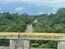
The Sagua la Chica River on the Circuito Norte
Villages
Towns and villages near the Sauga la Chica include:
- Falcón
- El Berro
- Crucero Carmita
- Luis Arcos Bergnes (or Carmita)
- Vega Alta
- Canoa (or La Canoa)
- Rincón (or El Rincón)
- El Perico (or Perico)
- Pavón
- Las Bocas
- Vega Redonda
- Arroyo Naranjo
- Sagua la Chica (town)
- El Santo
References
- Gannett, Henry (1902). A Gazeteer of Cuba. Bulletin of the United States Geological Survey (Series F, Geography, 29). Washington: Government Printing Office. p. 92.
- The Columbia Gazetteer of North America. 2000.
This article is issued from Wikipedia. The text is licensed under Creative Commons - Attribution - Sharealike. Additional terms may apply for the media files.