Sandusky, Ohio
Sandusky (/sænˈdʌski/ san-DUSS-kee) is a city in and the county seat of Erie County, Ohio, United States.[5] Situated along the southern shore of Lake Erie, Sandusky is located roughly midway between Toledo (45 miles (72 km) west) and Cleveland (50 miles (80 km) east). According to 2020 census, the city had a population of 25,095,[6] and the Sandusky metropolitan area had 115,986 residents.[7]
Sandusky, Ohio | |
|---|---|
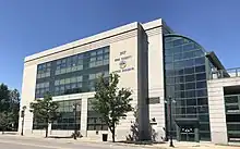
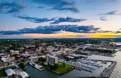 Downtown Sandusky | |
 Seal | |
| Nickname: "Home of Cedar Point" | |
Interactive map of Sandusky | |
 Sandusky  Sandusky | |
| Coordinates: 41°26′48″N 82°42′33″W | |
| Country | |
| State | |
| County | Erie |
| Founded | 1818 |
| Government | |
| • City Manager | John Orzech Jr. |
| • Commissioners | Richard R. Brady Dennis E. Murray C. Wesley Poole Michael R. Meinzer Blake A. Harris Stephen R. Poggiali David L. Waddington |
| Area | |
| • City | 21.83 sq mi (56.53 km2) |
| • Land | 9.63 sq mi (24.96 km2) |
| • Water | 12.19 sq mi (31.58 km2) |
| Elevation | 597 ft (182 m) |
| Population (2020) | |
| • City | 25,095 |
| • Density | 2,604.57/sq mi (1,005.58/km2) |
| • Metro | 75,662 |
| Time zone | UTC−05:00 (EST) |
| • Summer (DST) | UTC−04:00 (EDT) |
| ZIP Codes | 44870–44871 |
| Area code | 419/567 |
| FIPS code | 39-70380[3] |
| GNIS feature ID | 1076832[4] |
| Website | www |
Sandusky is home to the Cedar Fair Entertainment Company, which owns large amounts of property in Sandusky. These properties include Cedar Point, Cedar Fair's flagship park and one of the most popular amusement parks in the world, as well as Cedar Point Shores waterpark, adjacent to Cedar Point itself.[8][9] In 2011, Sandusky was ranked No. 1 by Forbes as the "Best Place to Live Cheaply" in the United States due to its high median family income of $64,000 compared to its relatively low cost of living.[10] The National Arbor Day Foundation has designated Sandusky as a Tree City USA.
Etymology
The accepted etymology is that the name "Sandusky" is derived from the Wyandot word saundustee, meaning "water"[11][12] or andusti, "cold water."[13] In his 1734 history of New France, Charlevoix transliterated the word as "Chinouski." Sandusky Bay, formed at the mouth of the Sandusky River, is identified as "Lac (Lake) Sandouské" on a 1718 map by Guillaume DeLisle.[14] The name "L.(Lac) Sandoski" appears on a 1733 map.[15] Sandusky Bay was also called Lac Ondaské, in another French transliteration of the Wyandot.[16]
The river and bay gave rise to a number of eponymous forts and settlements along their shores. These consisted of the short-lived English trading post Fort Sandusky north of the bay, the French Fort Sandoské that replaced it, the British Fort Sandusky on the south shore of the bay, the American Fort Sandusky (later Fort Stephenson) upriver at Lower Sandusky (now known as Fremont, Ohio), as well as the Wyandot Indian village of Upper Sandusky farther upriver.[16]
Another, less accepted etymologic version claims that the city's name goes back to an American trader and frontiersman named Anthony Sadowski, a neighbor of the Boone family and co-founder of Amity village. He was employed by the governor of then British Pennsylvania as a trader and interpreter, speaking several Indian languages, especially Iroquois. He moved to the Pennsylvania frontier in January 1712 and could easily have made it to Lake Erie by 1718 to establish a trading post. One genealogical line of his descendants is actually called "Sandusky."
History
_(14574386070).jpg.webp)
This area was a center of trading and fortifications since the 18th century: the English, French, and Americans had trading posts and forts built on both the north and south sides of Sandusky Bay.[16] George Croghan was one of the more prominent men who operated in this area in the 18th century. A federal fur trade factory was established in 1808 but was lost at the beginning of the War of 1812.[17]
Development by European Americans of the city of Sandusky, starting in 1818, on the southeast shore of Sandusky Bay, followed settlement of the war of 1812. Part of the city quickly enveloped the site of an earlier small village named Portland (established about 1816). Sandusky was incorporated as a city in 1824.[18] Eventually the city of Sandusky encompassed most of the entire township that had been called Portland.[19] Some of the city was built on land formerly occupied by a Native American man named Ogontz, and therefore the city is said to have been built on "Ogontz' place".
Sandusky's rise in the 19th century was heavily influenced by its location at the head of Sandusky Bay. This made it a key point both for the movement of goods and for the movement of people. The mild climate caused by its proximity to Lake Erie also caused it to become the center of Ohio's wine industry. The presence of limestone was also important in its development. It was also a key location for ice harvesting in the 19th century.[20] Lumber transport, stone quarrying and, in the early 20th century, manufacturing, have all contributed to the city's economic development.
Prior to the abolition of slavery in the United States, Sandusky was a stop for refugee slaves on the Underground Railroad, as some would travel across Lake Erie to reach freedom in Canada. Although Ohio was a free state, they felt at risk from slavecatchers because of bonuses offered under the Fugitive Slave Act of 1850. As depicted in Harriet Beecher Stowe's novel Uncle Tom's Cabin (1855), many refugee slaves seeking to get to Canada made their way to Sandusky, where they boarded boats crossing Lake Erie to the port of Amherstburg in Ontario.
Sandusky's original plat was designed by surveyor Hector Kilbourne according to a modified grid plan, known today as the Kilbourne Plat. Kilbourne later became the first Worshipful Master of the first Sandusky Masonic Lodge, known as Science Lodge #50, still in operation on Wayne Street. His design featured a street grid with avenues cutting diagonally to create patterns reminiscent of the symbols of Freemasonry.
On September 17, 1835, Sandusky was the site of groundbreaking for the Mad River and Lake Erie Railroad, which brought change to the town. Industrial areas developed near the railroad and goods were transported through the port. The coal docks located west of downtown still use a portion of the original MR&LE right-of-way. In 1838 Erie County, Ohio was formed by the state legislature and Sandusky was designated the county seat. This led to the foundation of a court house and Sandusky becoming a regional government center.[21] In 1846 Sandusky had a population of approximately 3,000 people. At that point Sandusky had two railroads and was also a main focus of lake traffic. The town then consisted of many stores, two printing offices, two machine shops, two banks, six churches, one high school, and several iron furnaces.[22]

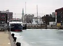
Since the late 20th century, Battery Park Marina was developed on the original site of the MR&LE Railroad after restructuring of the industry reduced traffic on the line. The tracks that ran through downtown Sandusky have since been removed. Most of the downtown industrial area is also being redeveloped for other purposes, including mainly marina dockage.
The English author Charles Dickens visited the city in 1842, and briefly wrote of it in his subsequent travelogue, American Notes. Said Dickens, who rode the newly constructed MR&LE railroad from Tiffin:
At two o'clock we took the railroad; the travelling-on which was very slow, its construction being indifferent, and the ground wet and marshy; and arrived at Sandusky in time to dine that evening. We put up at a comfortable little hotel on the brink of Lake Erie, lay there that night, and had no choice but to wait there next day, until a steamboat bound for Buffalo appeared. The town, which was sluggish and uninteresting enough, was something like the back of an English watering-place out of the season.
By 1880 Sandusky had risen to a population of 16,000. There were then 20 churches and three newspapers in the community. The city boasted 29 businesses with at least 10 employees. Products being products included lime, railroad locomotives and cars, carriages, wheels, crayons, chalk, beer, paper, baskets, and tools.[22] By 1886 Sandusky was the center of wood wheel manufacture in the United States. It was also the location of the Ohio State Fish hatchery and the Ohio Soldiers and Sailor's Home.[22]
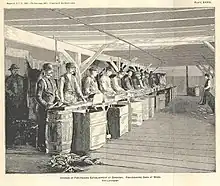
The city developed as a center of paper-making. With a mill in the industrial area near the lake, the Hinde & Dauch Paper Company was the largest employer in the city in the early 1900s.
As the 20th century progressed, the economy of Sandusky came to focus mainly on tourism and fishing.
Geography
Geography

Sandusky is located at 41°26′48″N 82°42′33″W (41.446741, −82.709092).[23]
According to the United States Census Bureau, the city has a total area of 21.91 square miles (56.75 km2), of which 9.73 square miles (25.20 km2) is land and 12.18 square miles (31.55 km2) is water.[24]
Sandusky occupies the defunct township Portland[25] and borders the following townships:
- Margaretta Township - west and south
- Perkins Township - south
- Huron Township - east
Climate
Sandusky has a humid continental climate (Köppen climate classification Dfa), typical of the Midwestern United States, with warm summers and cold winters. Winters tend to be cold, with an average January high temperature of 32 °F (0 °C), and an average January low temperature of 19 °F (−7 °C), with considerable variation in temperatures. Sandusky averages 23.3 inches (59 cm) of snow per winter.[26] Summers tend to be warm with an average July high temperature of 82 °F (28 °C), and an average July low temperature of 66 °F (19 °C). Summer weather is more stable, generally humid with thunderstorms. Fall usually is the driest season with many clear warm days and cool nights.
The highest recorded temperature in Sandusky of 105 °F (41 °C) was set on July 14, 1936, and the lowest recorded temperature of −20 °F (−29 °C) was set on January 19, 1994.[27]
| Climate data for Sandusky, Ohio (1991–2020 normals, extremes 1896–present) | |||||||||||||
|---|---|---|---|---|---|---|---|---|---|---|---|---|---|
| Month | Jan | Feb | Mar | Apr | May | Jun | Jul | Aug | Sep | Oct | Nov | Dec | Year |
| Record high °F (°C) | 73 (23) |
75 (24) |
85 (29) |
90 (32) |
93 (34) |
104 (40) |
105 (41) |
105 (41) |
99 (37) |
93 (34) |
82 (28) |
73 (23) |
105 (41) |
| Average high °F (°C) | 34.4 (1.3) |
37.0 (2.8) |
45.0 (7.2) |
57.3 (14.1) |
68.5 (20.3) |
78.1 (25.6) |
82.3 (27.9) |
80.5 (26.9) |
74.5 (23.6) |
63.0 (17.2) |
50.1 (10.1) |
39.3 (4.1) |
59.2 (15.1) |
| Daily mean °F (°C) | 28.1 (−2.2) |
30.2 (−1.0) |
38.0 (3.3) |
49.3 (9.6) |
60.8 (16.0) |
70.8 (21.6) |
74.7 (23.7) |
73.2 (22.9) |
66.7 (19.3) |
55.3 (12.9) |
43.5 (6.4) |
33.6 (0.9) |
52.0 (11.1) |
| Average low °F (°C) | 21.8 (−5.7) |
23.4 (−4.8) |
30.9 (−0.6) |
41.3 (5.2) |
53.2 (11.8) |
63.4 (17.4) |
67.2 (19.6) |
65.8 (18.8) |
58.9 (14.9) |
47.6 (8.7) |
36.8 (2.7) |
27.8 (−2.3) |
44.8 (7.1) |
| Record low °F (°C) | −20 (−29) |
−15 (−26) |
−7 (−22) |
14 (−10) |
30 (−1) |
41 (5) |
41 (5) |
45 (7) |
34 (1) |
22 (−6) |
3 (−16) |
−16 (−27) |
−20 (−29) |
| Average precipitation inches (mm) | 1.90 (48) |
1.77 (45) |
2.56 (65) |
3.76 (96) |
3.25 (83) |
3.67 (93) |
3.55 (90) |
3.02 (77) |
3.07 (78) |
2.72 (69) |
2.64 (67) |
2.12 (54) |
34.03 (864) |
| Average snowfall inches (cm) | 5.4 (14) |
4.1 (10) |
2.7 (6.9) |
0.6 (1.5) |
0.0 (0.0) |
0.0 (0.0) |
0.0 (0.0) |
0.0 (0.0) |
0.0 (0.0) |
0.0 (0.0) |
0.1 (0.25) |
3.3 (8.4) |
16.2 (41) |
| Average precipitation days (≥ 0.01 in) | 10.6 | 10.1 | 12.2 | 13.1 | 13.3 | 12.1 | 9.8 | 9.7 | 10.0 | 11.8 | 11.1 | 11.7 | 135.5 |
| Average snowy days (≥ 0.1 in) | 3.8 | 2.3 | 1.4 | 0.2 | 0.0 | 0.0 | 0.0 | 0.0 | 0.0 | 0.0 | 0.1 | 1.9 | 9.7 |
| Source: NOAA (snow 1981–2010)[28][29][30] | |||||||||||||
Local areas
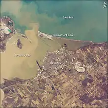
Historically, the Wyandot used the term andoske to refer to the river, the bay, and the general area where the city of "Sandusky" later developed. This practice was also used by French and English settlers in the area. Often in historical documents, the word "Sandusky" is used without clarification as to which specific site or location is being referred to. Historical references to "Sandusky" might mean any one of the following locations, depending also on the date of the reference.[31]
List of locations, with approximate dates of usage:
- Sandusky/Sandusky City - about 1817* to present, village/city on southeast side of Sandusky Bay (*-any "Sandusky" reference dated prior to 1817 would not refer to this village, as it was not officially established by this name until 1818).
- Sandusky Bay - 1700 to present; early variants were "(Lac d')Otsanderket", "(Lac d')Otsandoske", "Lake Sandoskė".
- Sandusky River - 1740s to present.
- Fort Sandusky - various locations: c. 1745, an English trading post on the northern side of the bay. c.1754, a French fort ("Fort Janundat") was built on the southern side of the bay. Later in the French and Indian War, the British built Fort Sandusky on the southeastern side of Sandusky Bay. From about 1812/1813, this referred to a fort (later called "Fort Stephenson") on the Sandusky River, near present-day Fremont, Ohio.
- Lower Sandusky - 1760s to 1849, area or village at the site of what is now the city of Fremont.
- Upper Sandusky - 1760s? to present, area or village at the falls, which later developed as the current city of Upper Sandusky. Upper Sandusky is south of Sandusky and upriver of it. While a common first impression is that "Upper" implies "north of", here "Upper" refers to "upstream", as in upstream of Lake Erie by means of the Sandusky River.
- Upper Sandusky Old Town - 1760s? to ?, a historic Wyandot (Huron) tribe village, about 12 miles (19 km) north of where the city of Upper Sandusky developed.
.jpg.webp)
Demographics
| Census | Pop. | Note | %± |
|---|---|---|---|
| 1830 | 593 | — | |
| 1840 | 1,433 | 141.7% | |
| 1850 | 5,087 | 255.0% | |
| 1860 | 8,408 | 65.3% | |
| 1870 | 13,000 | 54.6% | |
| 1880 | 15,838 | 21.8% | |
| 1890 | 18,471 | 16.6% | |
| 1900 | 19,664 | 6.5% | |
| 1910 | 19,989 | 1.7% | |
| 1920 | 22,897 | 14.5% | |
| 1930 | 24,022 | 4.9% | |
| 1940 | 24,874 | 3.5% | |
| 1950 | 29,375 | 18.1% | |
| 1960 | 31,989 | 8.9% | |
| 1970 | 32,674 | 2.1% | |
| 1980 | 31,360 | −4.0% | |
| 1990 | 29,764 | −5.1% | |
| 2000 | 27,844 | −6.5% | |
| 2010 | 25,793 | −7.4% | |
| 2020 | 25,095 | −2.7% | |
| Sources:[3][32][33] | |||
2010 census
| Largest ancestries (2010) | Percent |
|---|---|
| German | 34.4% |
| Irish | 15.9% |
| English | 8.4% |
| Italian | 6.8% |
| American | 3.7% |
As of the census[34] of 2010, there were 25,793 people, 11,082 households, and 6,415 families residing in the city. The population density was 2,650.9 inhabitants per square mile (1,023.5/km2). There were 13,386 housing units at an average density of 1,375.7 per square mile (531.2/km2). The racial makeup of the city was 70.4% White, 22.0% African American, 0.4% Native American, 0.6% Asian, 1.1% from other races, and 5.5% from two or more races. Hispanic or Latino of any race were 4.9% of the population.
There were 11,082 households, of which 29.4% had children under the age of 18 living with them, 32.9% were married couples living together, 19.7% had a female householder with no husband present, 5.2% had a male householder with no wife present, and 42.1% were non-families. 35.1% of all households were made up of individuals, and 12.1% had someone living alone who was 65 years of age or older. The average household size was 2.28 and the average family size was 2.93.
The median age in the city was 38.5 years. 23.9% of residents were under the age of 18; 9.3% were between the ages of 18 and 24; 24.2% were from 25 to 44; 27.7% were from 45 to 64; and 15% were 65 years of age or older. The gender makeup of the city was 47.6% male and 52.4% female.
2000 census
| Largest ancestries (2000) | Percent |
|---|---|
| German | 32.1% |
| Irish | 12.4% |
| English | 7.8% |
| Italian | 7.4% |
| American | 6.7% |
As of the census[3] of 2000, there were 27,844 people, 11,851 households, and 7,039 families residing in the city. The population density was 2,770.5 inhabitants per square mile (1,069.7/km2). There were 13,323 housing units at an average density of 1,325.7 per square mile (511.9/km2). The racial makeup of the city was 74.50% White, 21.08% African American, 0.29% Native American, 0.26% Asian, 0.01% Pacific Islander, 0.97% from other races, and 2.88% from two or more races. Hispanic or Latino of any race were 3.09% of the population.
There were 11,851 households, out of which 28.9% had children under the age of 18 living with them, 38.7% were married couples living together, 16.4% had a female householder with no husband present, and 40.6% were non-families. 34.9% of all households were made up of individuals, and 13.1% had someone living alone who was 65 years of age or older. The average household size was 2.31 and the average family size was 2.99.
In the city the population was spread out, with 25.8% under the age of 18, 9.2% from 18 to 24, 28.5% from 25 to 44, 21.4% from 45 to 64, and 15.1% who were 65 years of age or older. The median age was 36 years. For every 100 females, there were 89.4 males. For every 100 females age 18 and over, there were 85.2 males.
The median income for a household in the city was $31,133, and the median income for a family was $37,749. Males had a median income of $31,269 versus $21,926 for females. The per capita income for the city was $18,111. About 12.2% of families and 15.3% of the population were below the poverty line, including 22.7% of those under age 18 and 10.2% of those age 65 or over.
Economy
Top employers
According to Sandusky's 2017 Comprehensive Annual Financial Report,[35] the top employers in the city are:
| # | Employer | # of Employees |
|---|---|---|
| 1 | Cedar Point | 6,070 |
| 2 | Firelands Regional Health System | 2,067 |
| 3 | Sandusky City School District | 750 |
| 4 | Erie County | 596 |
| 5 | Providence Care Center | 361 |
| 6 | City of Sandusky | 264 |
| 7 | JBT Corporation | 239 |
| 8 | LEWCO, Inc. | 219 |
| 9 | Stein Hospice Service | 180 |
| 10 | Okamoto Sandusky Manufacturing | 131 |
Tourism
The Jackson Street Pier is a newly renovated tourism destination in Downtown Sandusky on Shoreline Dr. It features an event center, great lawn, ferry dock, selfie locations, boardwalk around the edge, benches, fishing, ice cream vendors, and more.
Sandusky has a tourism industry fueled by Cedar Point, the neighboring islands, boating, and more recently by its many indoor and outdoor water parks. It is also noted for being the location of the (fictional) "Callahan Auto Parts" in the movie Tommy Boy.
Cedar Point
.JPG.webp)
Cedar Point is a major American amusement park located on Sandusky's coast on Lake Erie. One of America's oldest theme parks and popularly known as "America's Roller Coast", the park has the second largest collection of roller coasters at 17, behind only Six Flags Magic Mountain.[36][37] Additionally, Cedar Point is the only park in the world to have six roller coasters with heights of over 200 feet (61 m), and numerous Cedar Point roller coasters have set world records; the most notable of these being Magnum XL-200, Millennium Force, and Top Thrill Dragster each setting the record for the tallest full-circuit roller coaster at one point, and GateKeeper having the highest (from ground level) inversion of any roller coaster from 2013 to 2019, and today having the fourth highest inversion.[38][39]
Islands
May through August every year, Sandusky residents and incoming tourists flock to the neighboring islands north of the city, with many transportation options leaving right from downtown. The islands include Kelleys Island, South Bass Island (host of the popular village known as Put-in-Bay), Middle Bass Island and North Bass Island.
Themed parties are a common occurrence in the summer season throughout Sandusky and on the neighboring islands, such as "Island Fest", "Rock on the Dock", and "Christmas in July"; thousands of residents and tourists join in the festivities annually. In 2008, the residents of Sandusky hosted their first annual "Barge Party", where boats from as far as Toledo and Cleveland came to dock up their boats together at the sandbar, just inside Sandusky Bay.[40] The barge party ensues twice every year, typically in late June and late July.[40]
Waterparks

The tourist draw produced by Cedar Point has attracted resort businesses and waterparks to the area. Major waterparks in and near Sandusky are:
Outdoor
- Cedar Point Shores (formerly Soak City), owned by Cedar Fair
- Monsoon Lagoon (Danbury Township) Ottawa County
Indoor
- Castaway Bay, owned by Cedar Fair
- Great Wolf Lodge (Perkins Township)
- Kalahari (Perkins Township)
- Maui Sands Waterpark & Hotel (Closed because of water damage)
- Rain Indoor Waterpark Located in Quality Inn & Suites (closed)
Museums
Sandusky is home to several museums and historic homes. These include the Cooke-Dorn House historic site which was the home of Eleutheros Cooke, the Follett House Museum which was the home of Oran Follett, the Maritime Museum of Sandusky, the Merry-Go Round Museum, and the Ohio Veterans Home Museum.[41]
Government
City Manager
The City of Sandusky's top government executive is called the City Manager. John Orzech Jr. (D) is the current City Manager for the City of Sandusky. City Manager Orzech is 56 years old and has held the position since November of 2022.
City Commission
The City Commission consists of seven electors of Sandusky, elected to represent the city at large. City Commissioners are elected for terms of four years. The current City Commissioners are:
Richard R. Brady, Commission President
Dennis E. Murray, Commission Vice President
Michael R. Meinzer
Blake A. Harris
C. Wesley Poole
Stephen R. Poggiali
Police & Fire
Safety Service Leaders
Sandusky Police Chief: Jared Oliver, Since 2020
Sandusky Fire Chief: Mario D'Amico, Since 2021
Politics
Sandusky is heavily Democratic when it comes to elections. It is, on average, a 70% - 30%, Democratic stronghold for the region. Sandusky is represented by US Rep. Marcy Kaptur (D-Toledo) in congress and the city has voted for Democratic presidential candidates for decades.
Education
Sandusky Public Schools enroll 3,775 students in public primary and secondary schools.[42] Sandusky City Schools operates six public schools. Sandusky Early Learning Academy, constructed on the grounds of the former Hancock Elementary School, serves Pre-K and Kindergarten students. Sandusky Primary School, constructed on the grounds of the former Ontario Elementary School, serves 1st and 2nd grade students. Sandusky Intermediate School serves grades 3rd through 6th. Sandusky Middle School, serves grades 7th and 8th, which moved to Sandusky High School after the closing of Adams Junior High (formerly served 7th grade) and Jackson Junior High (formerly served 8th grade). Sandusky High School serves 9th through 12th grade students. Sandusky Digital Academy is an alternative school for students who struggle in mainstream classrooms. Sandusky Career Center offers vocational programs for adults, now located at the former Venice Elementary School.
Alternatively, St. Mary Central Catholic High School, a private Roman Catholic school associated with Holy Angels Church, St. Mary's Church, and Sts. Peter & Paul Church, focuses on giving students a faith-centered learning environment. Monroe Prep Academy is a private charter school in downtown Sandusky. It is located on E. Monroe St. on Sandusky's East Side.
Sandusky is served by the Sandusky Library, which also operates a branch on Kelleys Island.[43]
Media
Print
Sandusky (along with nearby Port Clinton and the Lake Erie Islands - known in the region collectively as "Vacationland")[44] is served by a daily newspaper, the Sandusky Register.
TV
The Vacationland region–which encompasses Sandusky–has one locally targeted television station, religiously oriented WGGN-TV channel 52. Sandusky's location between Toledo and Cleveland means that the city is also served by stations (albeit at a fringe level) in both of those markets as well.
Radio
Twelve local radio stations serve the Sandusky/Vacationland market. BAS Broadcasting, based in nearby Fremont, owns and operates WCPZ 102.7 FM (hot AC), WMJK 100.9 FM (country), WOHF 92.1 FM (classic hits), WFRO-FM 99.1 FM (AC), and WLEC 1450 AM/93.5 FM (oldies/sports/full service).[45] Elyria-Lorain Broadcasting Co. operates three stations serving the "Vacationland" region, including WKFM 96.1 FM (country), WLKR-FM 95.3 (Adult album alternative) and WLKR 1510 AM/92.9 FM (classic hits).[46] Ideastream Public Media operates Kent State University-owned WNRK 90.7 FM (NPR news/information), a repeater of WKSU in Kent.[47]
Religious stations include WVMS 89.5 FM (run by the Moody Bible Institute as a repeater of WCRF in Cleveland), WGGN 97.7 FM (Contemporary Christian) and WHRQ 88.1 FM (carrying Toledo-based Annunciation Radio, an EWTN Radio affiliate).
Transportation
Sandusky Transit System (STS) runs a full-service transit system across the Greater Sandusky Area. Its located at 1230 N. Depot St.
Blue Line: serves the suburban area, route 250, Sandusky Mall, and Kalahari Resort. Red: Serves the East side and Downtown. Yellow: Cedar Point, Sports Center. Orange: Midtown Purple: Serves the south side. Green: Serves the west side.
Amtrak, the national passenger rail system, provides service to Sandusky. There are four trains daily, all arriving in the late night/early morning hours: the Capitol Limited between Chicago and Washington, D.C., via Pittsburgh; and the Lake Shore Limited between Chicago and New York/Boston via Buffalo. The Sandusky Amtrak Station is also home to a Greyhound Lines bus station. Into the 1930s, the Baltimore and Ohio Railroad operated a passenger train from Willard in north-central Ohio, as a section of a Wheeling, WV-Chicago train.[49]
Several ferry boats and routes serve Sandusky. These depart from the Jackson Street Pier, except Jet Express which departs from an adjacent pier.
- M/V Goodtime I - Seasonal daily service to Kelleys Island and South Bass Island. Also provides special party cruises and charters.
- M/V Pelee Islander - Seasonal scheduled service to Pelee Island connecting to Leamington, Ontario and Kingsville, Ontario.
- Jet Express - Provides seasonal daily service to Kelleys Island, South Bass Island, and Cedar Point which connect to Port Clinton, Ohio. It also provides excursion and cruises. Departs from former Cedar Point pier downtown.
The city was previously served by Griffing Sandusky Airport until its closure in 2013. The community is currently served by Erie–Ottawa International Airport in nearby Port Clinton for general aviation and limited commercial service to the Lake Erie Islands.[50] Today, flights from Detroit Metropolitan Airport, John Glenn Columbus International Airport, Cleveland Hopkins International Airport serve Sandusky.
In terms of road access, Sandusky is a short drive off the Ohio Turnpike (Interstate 90 and Interstate 80), enabling easy transportation to Sandusky from cities like Toledo, Cleveland, and Erie, Pennsylvania via those roads. U.S. Route 6 runs through Sandusky, and both Ohio State Route 4 and U.S. Route 250 converge on Sandusky.
Notable people
- John Jay Barber (1840–1910), painter
- John Beatty (1828–1914), banker, U.S. Representative (1868–1873); brigadier general during Civil War
- Bill Berry, drummer for band R.E.M.; lived in Sandusky 1968–1972
- Andrew Biemiller, U.S. Representative from Wisconsin
- Brian Bixler, Major League Baseball player
- Brandy Burre, actress, played Theresa D'Agostino on HBO series The Wire
- Roger Carter, professional darts player
- Chris Castle, folk/Americana singer-songwriter
- Dandridge MacFarlan Cole (1921–65), aerospace engineer, futurist, author
- Henry D. Cooke (1825–81), financier, journalist, railroad executive, politician
- Jay Cooke (1821–1905), Civil War financier, railroad magnate, philanthropist
- Jay Crawford, sportscaster
- Corey Croom, football player
- Thom Darden, defensive back for Cleveland Browns, 1972–1981
- Robert L. Denig, major general, Marine Corps; Sandusky's highest-ranking sea service officer
- John Emerson, born Clifton Paden (1874–1956), actor, playwright, director of silent films
- Chad Fairchild, Major League Baseball umpire
- George Feick (1849–1932), builder of Wyoming State Capitol, buildings in and near Sandusky
- Charles Frohman (1856–1915), producer, co-founder of Theatrical Syndicate
- Daniel Frohman (1851–1940), theatrical producer, film producer
- Andy Gerold, guitarist with Marilyn Manson
- Jon Gruden, NFL head coach and TV analyst
- Fred Kelsey (1884–1961), actor, director
- Dick Kinzel, CEO of Cedar Fair Entertainment Company
- Aaron Kromer, NFL assistant coach
- Jeff Linkenbach, NFL offensive tackle
- William d'Alton Mann (1839–1920), Civil War soldier, businessman, publisher
- Scott May, basketball player, NCAA national champion, 1976 Player of the Year, 1976 Olympic gold medalist; NBA player
- Jackie Mayer, Miss America 1963; section of Route 2 in Erie County is named "Jackie Mayer Miss America Highway"
- Betty Mitchell, theatre director and educator
- Thomas J. Moyer (1939–2010), chief justice of Ohio Supreme Court from 1987 to 2010
- Dennis Murray, Democratic member of Ohio House of Representatives
- George Nichols, light heavyweight boxing champion
- James Obergefell, LGBT rights activist and United States Supreme Court plaintiff in Obergefell v. Hodges
- Catherine Opie, artist, professor of photography at UCLA
- Orlando Pace, offensive lineman in Pro Football Hall of Fame; played for Sandusky High School, which retired his jersey number
- Kevin Randleman, Former UFC Heavyweight Champion, two-time Division I NCAA wrestling champion for The Ohio State University, mixed martial arts fighter
- Blanche Roosevelt (1853–98), opera singer and author
- Edmund Ross, senator whose vote prevented impeachment of President Andrew Johnson
- William F. Schaub (1900–1999), U.S. Assistant Secretary of Army 1961–1962
- Elmer Smith (1892–1984), Major League Baseball outfielder 1914–1925; helped Cleveland Indians win the 1920 World Series
- Brad Snyder, Major League Baseball player
- Todd Stephens, film director, writer and producer
- Orville James Victor (1827–1910), theologian, journalist, abolitionist
- Dave Waddington, powerlifter and strongman; first to break 1,000-pound barrier in squat
- Alvin F. Weichel (1891–1956), Republican in U.S. House of Representatives (1943–1955)
References
- "City Commission Meet Your Commissioners". City of Sandusky. Archived from the original on February 9, 2013. Retrieved January 16, 2016.
- "ArcGIS REST Services Directory". United States Census Bureau. Retrieved September 20, 2022.
- "U.S. Census website". United States Census Bureau. Retrieved January 31, 2008.
- "US Board on Geographic Names". United States Geological Survey. October 25, 2007. Retrieved January 31, 2008.
- "Find a County". National Association of Counties. Retrieved June 7, 2011.
- "Census - Geography Profile: Sandusky city, Ohio". United States Census Bureau. Retrieved March 31, 2022.
- "Census - Geography Profile: Erie County, Ohio". United States Census Bureau. Retrieved March 31, 2022.
- "Cedar Point Shores Waterpark | Ohio's Lake Erie Shores & Islands". www.shoresandislands.com. Retrieved May 26, 2021.
- "Roller Coasters | Adrenaline Rush Activities | Cedar Point". www.cedarpoint.com. Retrieved September 13, 2017.
- Fisher, Daniel (August 10, 2011). "Best Places To Live Cheaply". Forbes.
- "Wyandot Dictionary" (PDF). Retrieved May 22, 2012.
saándú(sti) water
- Johnston, John (1858). Vocabularies of the Shawanoese and Wyandott Languages, etc. Retrieved February 27, 2017.
{{cite book}}:|website=ignored (help) - "Wyandot Dictionary" (PDF). Retrieved May 22, 2012.
aándú(stɛ̨) [or] aándú(sti) cold.water
- "Carte de la Louisiane et du cours du Mississipi [i.e. Mississippi]: dressâee sur un grand nombre de mâemoires entrautres sur ceux de Mr. le Maire / par Guillaume Del'isle del Academie R'le. des Sciences". Memory.loc.gov. Retrieved March 5, 2014.
- "Composite: British Empire in America. / Popple, Henry / 1733". Davidrumsey.com. February 22, 1999. Retrieved March 5, 2014.
- Lucy Elliot Keeler (September 15, 1912). Old Fort Sandoski of 1745 and the 'Sandusky Country'. pp. 357–405. Retrieved July 31, 2018.
{{cite book}}:|work=ignored (help) - Wesley, Edgar Bruce (1935). Guarding the Frontier. University of Minnesota Press, p. 40.
- Cleveland Memory entry on Sandusky
- Williams, William W. (1879). History of the Fire Lands, Comprising Huron and Erie Counties, Ohio. Press of Leader Printing Company. p. 431.
- Cleveland Memory article on Sandusky
- Ohio history central article on Sandusky
- Ohio History Central article on Sandusky
- "US Gazetteer files: 2010, 2000, and 1990". United States Census Bureau. February 12, 2011. Retrieved April 23, 2011.
- "US Gazetteer files 2010". United States Census Bureau. Archived from the original on January 25, 2012. Retrieved January 6, 2013.
- https://commons.m.wikimedia.org/wiki/File:Map_of_Erie_%26_part_of_Ottowa_Counties,_Ohio_-_showing_the_sections,_farms,_lots_and_villages_LOC_2012592231.jpg
- "Weatherbase: Historical Weather for Sandusky, Ohio". Retrieved on 2008-11-13.
- Monthly Averages for Sandusky, OH. The Weather Channel. Retrieved on 2008-11-13.
- "NowData – NOAA Online Weather Data". National Oceanic and Atmospheric Administration. Retrieved May 9, 2021.
- "Station: Sandusky, OH". U.S. Climate Normals 2020: U.S. Monthly Climate Normals (1991-2020). National Oceanic and Atmospheric Administration. Retrieved May 9, 2021.
- "Station: Sandusky, OH". U.S. Monthly Climate Normals (1981-2010). National Oceanic and Atmospheric Administration. Retrieved May 9, 2021.
- Lucy Elliot Keeler (September 15, 1912). Old Fort Sandoski of 1745 and the 'Sandusky Country'. pp. 357–368. Retrieved July 31, 2018.
{{cite book}}:|work=ignored (help) - "Number of Inhabitants: Ohio" (PDF). 18th Census of the United States. U.S. Census Bureau. 1960. Retrieved May 17, 2020.
- "Ohio: Population and Housing Unit Counts" (PDF). U.S. Census Bureau. Retrieved May 17, 2020.
- "U.S. Census website". United States Census Bureau. Retrieved January 6, 2013.
- "City of Sandusky CAFR" (PDF). ci.sandusky.oh.us. Retrieved March 16, 2019.
- "Top 10 roller coasters at Cedar Point". Los Angeles Times. July 15, 2011. Retrieved May 26, 2021.
- "Theme Park History: Cedar Point - Then and Now". Theme Park Insider. Retrieved May 26, 2021.
- "Highest roller coaster inversions - Coasterpedia - The Roller Coaster and Flat Ride Wiki". coasterpedia.net. Retrieved May 26, 2021.
- "Tallest roller coasters - Coasterpedia - The Roller Coaster and Flat Ride Wiki". coasterpedia.net. Retrieved May 26, 2021.
- "Welcome". Sanduskybaybargeparty.com.
- erie County Historic Sites listing
- Great Schools.com. "Sandusky City School District Profile". Retrieved July 21, 2008.
- "About us". Sandusky Library. Retrieved February 25, 2018.
- "Sandusky History: Ohio's Lake Erie Vacationland". Sanduskyhistory.blogspot.com. June 10, 2010. Retrieved February 27, 2017.
- "BAS Broadcasting - Your Ohio Radio Stations". Basohio.com. Retrieved February 27, 2017.
- "Elyria-Lorain Broadcasting Company". Elbc.northcoastnow.com. Retrieved February 27, 2017.
- Jackson, Tom (March 31, 2022). "Public radio offerings change on local radio dials". sanduskyregister.com. Retrieved April 19, 2022.
- Sandusky Transit System. "Maps and Schedules". sandusky.oh.us.
- "Baltimore and Ohio Railroad, Table 39". Official Guide of the Railways. National Railway Publication Company. 96 (1). February 1932.
- "Erie Islands | Griffing Flying Service | United States". griffing. Retrieved November 1, 2020.
External links
Municipalities and communities of Erie County, Ohio, United States | ||
|---|---|---|
| Cities | 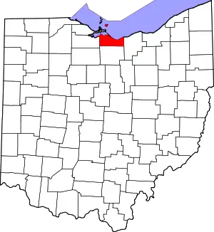 Map of Ohio highlighting Erie County | |
| Villages | ||
| Townships | ||
| CDPs | ||
| Other communities | ||
| Footnotes | ‡This populated place also has portions in an adjacent county or counties | |