Sarysu (river)
The Sarysu (Kazakh: Сарысу, Sarysu; Russian: Сарысу́, Sarysu) is a river in Karaganda, Turkistan and Kyzylorda Regions of Kazakhstan. It is 671 kilometres (417 mi) long, and has a drainage basin of 81,600 square kilometres (31,500 sq mi).[1]
| Sarysu Сарысу | |
|---|---|
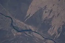 ISS image of the river | |
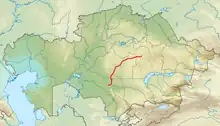 Map showing the course of the Sarysu | |
| Location | |
| Country | Kazakhstan |
| Physical characteristics | |
| Source | confluence of Zhaman-Sarysu and Zhaksy-Sarysu Kazakh Uplands |
| • coordinates | 48°40′28″N 71°35′38″E |
| • elevation | 477 m (1,565 ft) |
| Mouth | Telikol |
• coordinates | 45°12′39″N 66°36′28″E |
• elevation | 128 m (420 ft) |
| Length | 671 km (417 mi) |
| Basin size | 81,600 km2 (31,500 sq mi) |
| Discharge | |
| • average | 7.3 m3/s (260 cu ft/s) |
The name sary su means yellow water in Turkic languages.
Course
It arises above Atasu and flows generally westward to Kzyl-Dzhar where it turns south-westward past Birlestik and Zhanabas, then heading ever-more southerly it ends in the Telikol, across a cluster of small intermittent lakes at the western end of the Ashchykol Depression and to the east of the Dariyaly plain. River Boktykaryn runs parallel to it just before the Sarysu bends west towards the Telikol.[2][3][4]
The 181 kilometers (112 mi) long Shieli-Telikol Canal was built for irrigation, connecting the Telikol lacustrine basin to the north with the Syr Darya river near Shieli.[5]
See also
References
- Сарысу, Great Soviet Encyclopedia
- "M-42 Topographic Chart (in Russian)". Retrieved 25 July 2022.
- . Brockhaus and Efron Encyclopedic Dictionary (in Russian). 1906.
- Сырдарья (река), Great Soviet Encyclopedia
- "L-42 Topographic Chart (in Russian)". Retrieved 11 November 2022.
- Allen, W. E. D. (1956) "The Sources for G. Delisle's "Carte des Pays Voisins de la Mer Caspiene" of 1723" Imago Mundi 13: pp. 137–150, p. 139