Scheduled monuments in West Somerset (A–G)
West Somerset was a local government district in the English county of Somerset. It merged with Taunton Deane to form Somerset West and Taunton on 1 April 2019.
Monuments
| Name | Location | Type | Completed [note 1] | Grid ref.[note 2] Geo-coordinates | Notes | Entry number [note 3] | Image | Ref. |
|---|---|---|---|---|---|---|---|---|
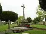
| Agnes Fountain | Selworthy | Holy well | Middle Ages | SS 90477 47370 51°12′54″N 3°34′10″W | A medieval holy well formed from stone slabs. | 1020827 | 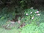 Agnes Fountain | [1] |
| Alderman's Barrow N of Almsworthy Common | Exford | Bowl barrow | Bronze Age | SS 83680 42326 51°10′06″N 3°39′54″W | A bowl barrow 24 metres (79 ft) in diameter. | 1006203 | .jpg.webp) Alderman's Barrow N of Almsworthy Common | [2] |
| Allerford New Bridge | Luccombe | Bridge | 1630 | SS 89989 46655 51°12′31″N 3°34′34″W | A medieval stone bridge which was largely rebuilt in 1630 and again in 1866 over Horner Water. | 1006197 |  Upload Photo | [3][4] |
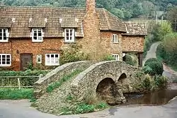
| Allerford packhorse bridge, immediately north of Cross Lane Farm | Allerford | Bridge | Middle Ages | SS 90512 46923 51°12′58″N 3°34′09″W | Built as a crossing over the River Aller, it is thought to be medieval in origin. The 18 feet (5.5 m) wide pointed arch rises 8 feet (2.4 m) with a 4 feet (1.2 m) span half arch on the side for flood relief. Originally the bridge was 3.7 metres (12 ft) wide but another 1.8 metres (6 ft) was added in 1866. | 1020776 | [5] | |
| Almsworthy Common: a stone alignment 560 m south west of Chetsford Bridge | Exford | Stone row | Late Neolithic to middle Bronze Age | SS 84309 41698 51°09′46″N 3°39′21″W | Four rows of standing stones between 100 millimetres (3.9 in) and 700 millimetres (28 in) high. There are 14 stones in total. | 1015017 | .jpg.webp) Almsworthy Common: a stone alignment 560 m south west of Chetsford Bridge | [6] |
| Bagley Iron Age defended settlement enclosure and deserted medieval farm | Luccombe | Earthworks | Iron Age and Middle Ages | SS 88227 42569 51°10′17″N 3°36′01″W | Earthworks from a prehistoric defended settlement and medieval village. | 1008468 | Upload Photo | [7] |
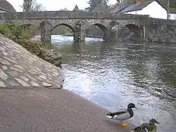
| Barle Bridge | Dulverton | Bridge | Middle Ages | SS 91207 27823 51°02′22″N 3°33′11″W | A medieval five arch stone bridge over the River Barle which was widened in 1819 and further restored following flooding in the 1950s. | 1006179 | [8] | |
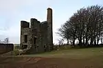
| Barlinch Priory | Brompton Regis | Priory | 12th century | SS 92891 28999 51°02′45″N 3°32′05″W | Barlynch Priory (also known as St Nicholas's Priory and sometimes spelled Barlich Priory) was Augustinian priory founded, by William de Say, between 1154 and 1189 and dissolved in 1537. The only visible remains are some fragments of walling attached to Barynch farmhouse. Some of the stained glass from a Jesse window at the Priory is now in the St Peter's Church in Huish Champflower. The priory has been added to the Heritage at Risk Register because of the risk of collapse. | 1006213 | Upload Photo | [9][10] [11][12] |
| Barrow and cairn cemetery on Black Hill, 490 m north west of Crowcombe Park Gate | Holford | Cairn and bowl barrows | Bronze Age | ST 14539 38227 51°08′13″N 3°13′22″W | Four bowl barrows and a cairn make up the site of a Bronze Age cemetery on the Quantock Hills. | 1019381 | Upload Photo | [13] |
| Barrow at Wilmot's Pool and a cairn 45 m to the north | Holford | Bowl barrow | Bronze Age | ST1530838148 51°08′11″N 3°12′43″W | A Bronze Age bowl barrow which is 22 metres (72 ft) in diameter and 1.7 metres (5 ft 7 in) high. Nearby are two small cairns. | 1417361 | Upload Photo | [14] |
| Barrows on Longstone Hill | East Quantoxhead | Bowl barrow | Bronze Age | ST 13505 41345 51°09′53″N 3°14′18″W | Bowl barrows close to the Greenway Track. One is 19 metres (62 ft) in diameter and the others 6 metres (20 ft) although there is some uncertainty about whether they are natural or man made. | 1006157 | Upload Photo | [15][16] |
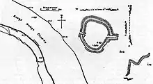
| Bat's Castle: a small multivallate hillfort and associated outwork | Carhampton | Hill fort | Iron Age | SS 98820 42146 51°10′11″N 3°26′55″W | Bat's Castle is an Iron Age hill fort at the top of a 213 metres (699 ft) high hill. It is on the highest point of Gallox Hill. Previously it was known as Caesar's Camp and is possibly associated with Black Ball Camp. Bat's Castle has two stone ramparts and two ditches. The ramparts are damaged in places and the hillfort is partly covered in scrub. | 1007667 | [17][18] [19][20] | |
| Beckham stone alignment and mound, 450 m south east of the Long Combe sheep pen | Exmoor | Stone row | Late Neolithic to middle Bronze Age | SS 80632 42382 51°10′06″N 3°42′31″W | Three parallel stone rows consisting of three standing and six recumbent stones. | 1014283 | Upload Photo | [21] |
| Bendel's Barrows, Exford Common | Exford | Round barrow | Bronze Age | SS 85388 40940 51°09′22″N 3°38′25″W | Two Bronze Age bowl barrows, one of 20 metres (66 ft) diameter and the other of 22 metres (72 ft). | 1006211 | Upload Photo | [22][23] |
| Berry Castle, Iron Age enclosure in Berry Castle Wood | Luccombe | Hillfort | Iron Age | SS 85919 44958 51°11′33″N 3°38′02″W | Berry Castle is an early Roman (possible Iron Age) hillslope enclosure. | 1006204 | Upload Photo | [24][25] |
| Black Ball Camp: a later prehistoric defended settlement on Gallox Hill | Dunster | Hill fort | Iron Age | SS 98428 42651 51°10′26″N 3°27′15″W | Black Ball Camp is an Iron Age hill fort . It is also known as British Camp and is possibly associated with Bat's Castle. It has a 3 metres (10 ft) high rampart and a 2 metres (7 ft) deep ditch. At the beginning of the 20th century the foundations of a stone tower were visible however this is no longer present. | 1007668 | [26][27] [28][29] | |
| Black Barrow | Exmoor | Round barrow | Bronze Age | SS 83211 44213 51°11′06″N 3°40′21″W | A round barrow which is 22 metres (72 ft) in diameter and 1.5 metres (4 ft 11 in) high. | 1006205 | 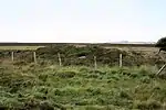 Black Barrow | [30] |
| Bowl barrow 80 m north of Halsway Post | Holford | Bowl barrow | Late Neolithic to Bronze Age | ST 14012 38612 51°08′25″N 3°13′50″W | A 7.5-metre (25 ft) diameter bowl barrow. | 1015084 | Upload Photo | [31] |
| Bowl barrow 100 m north west of Halsway Post | Holford | Bowl barrow | Late Neolithic to Bronze Age | ST 13962 38618 51°08′25″N 3°13′52″W | A 8.5-metre (28 ft) diameter bowl barrow. | 1015083 | Upload Photo | [32] |
| Bowl barrow 122 m NNW of Halsway Post | Holford | Bowl barrow | Late Neolithic to Bronze Age | ST 13968 38643 51°08′26″N 3°13′52″W | A bowl barrow which is 5.5 metres (18 ft) in diameter. | 1015082 | Upload Photo | [33] |
| Bowl barrow 225 m north west of Halsway Post | Holford | Bowl barrow | Late Neolithic to Bronze Age | ST 13860 38706 51°08′28″N 3°13′58″W | A 9.5-metre (31 ft) diameter bowl barrow. | 1015081 | Upload Photo | [34] |
| Bowl barrow 260 m north east of Ralegh's Cross Hotel | Nettlecombe | Bowl barrow | Late Neolithic to Bronze Age | ST 04142 34544 51°06′08″N 3°22′13″W | A 41-metre (135 ft) diameter bowl barrow. | 1020721 | Upload Photo | [35] |
| Bowl barrow 470 m north of Brendon Hill Farm | Brompton Regis | Bowl barrow | Late Neolithic to Bronze Age | ST 01269 33964 51°05′47″N 3°24′41″W | A 14-metre (46 ft) diameter bowl barrow. | 1020918 | Upload Photo | [36] |
| Bowl barrow 610 m ESE of the fire tower on Monkham Hill | Luxborough | Bowl barrow | Late Neolithic to Bronze Age | SS 99214 39134 51°08′33″N 3°26′32″W | A 19-metre (62 ft) diameter bowl barrow. | 1021227 | Upload Photo | [37] |
| Bowl barrow 650 m north west of Elworthy Barrows hillfort | Elworthy | Bowl barrow | Late Neolithic to Bronze Age | ST 06724 34262 51°06′00″N 3°20′01″W | A 19.5-metre (64 ft) diameter bowl barrow. | 1020725 | Upload Photo | [38] |
| Bowl barrow 700 m north east of Burrow Farm | Brompton Regis | Bowl barrow | Late Neolithic to Bronze Age | ST 01298 34620 51°06′09″N 3°24′40″W | A 14.5-metre (48 ft) diameter bowl barrow. | 1020777 | Upload Photo | [39] |
| Bowl barrow 780 m ESE of the fire tower on Monkham Hill | Luxborough | Bowl barrow | Late Neolithic to Bronze Age | SS 99357 39016 51°08′29″N 3°26′24″W | A 13.2-metre (43 ft) diameter bowl barrow. | 1021231 | Upload Photo | [40] |
| Bowl barrow and round cairn on Withypool Hill, 850 m and 820 m east of Portford Bridge | Withypool and Hawkridge | Bowl barrow and round cairn | Late Neolithic to Bronze Age | SS 83983 34411 51°05′50″N 3°39′30″W | A bowl barrow and round cairn 50 metres (160 ft) apart on Withypool Hill. The barrow is 20.5 metres (67 ft) and the cairn 3.5 metres (11 ft) in diameter. | 1021262 | 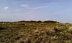 Bowl barrow and round cairn on Withypool Hill, 850 m and 820 m east of Portford Bridge | [41] |
| Bowl barrow called Chains Barrow | Exmoor | Bowl barrow | Late Neolithic to Bronze Age | SS 73458 41904 51°09′44″N 3°48′40″W | A 25-metre (82 ft) diameter bowl barrow. | 1006206 | Upload Photo | [42] |
| Bowl barrow on Longstone Hill, 270 m NNE of Bicknoller Post | East Quantoxhead | Bowl barrow | Late Neolithic to Bronze Age | ST 13033 40562 51°09′28″N 3°14′42″W | A 15-metre (49 ft) diameter bowl barrow. | 1014131 | Upload Photo | [43] |
| Bowl barrow on Longstone Hill, 270 m north east of Bicknoller Post | East Quantoxhead | Bowl barrow | Late Neolithic to Bronze Age | ST 13100 40485 51°09′25″N 3°14′38″W | A 11-metre (36 ft) diameter bowl barrow. | 1014130 | Upload Photo | [44] |
| Bowl barrow on Lype Hill, 550 m north west of Lype Farm | Cutcombe | Bowl barrow | Late Neolithic to Bronze Age | SS 95035 37112 51°07′25″N 3°30′04″W | A 21-metre (69 ft) diameter bowl barrow. | 1021062 | Upload Photo | [45] |
| Bowl barrow on Lype Hill, 750 m ENE of Heath Pault Cross | Cutcombe | Bowl barrow | Late Neolithic to Bronze Age | SS 94780 37046 51°07′23″N 3°30′18″W | A 15.8-metre (52 ft) diameter bowl barrow. | 1021063 | Upload Photo | [46] |
| Bowl barrow on Thorncombe Hill | Bicknoller | Bowl barrow | Late Neolithic to Bronze Age | ST 13162 39214 51°08′44″N 3°14′34″W | A bowl barrow which is approximately 12 metres (39 ft) north to south, 10 metres (33 ft) from east to west and is 1 metre (3 ft 3 in) high. | 1014129 | Upload Photo | [47] |
| Bowl barrow on Thorncombe Hill, 1.03 km north east of Paradise Farm | Bicknoller | Bowl barrow | Late Neolithic to Bronze Age | ST 13018 39461 51°08′52″N 3°14′42″W | A 9.3-metre (31 ft) diameter bowl barrow. | 1015079 | Upload Photo | [48] |
| Bowl barrow on Thorncombe Hill, 1.07 km north east of Paradise Farm | Bicknoller | Bowl barrow | Late Neolithic to Bronze Age | ST 13030 39495 51°08′53″N 3°14′41″W | A 7.5-metre (25 ft) diameter bowl barrow. | 1015078 | Upload Photo | [49] |
| Bowl barrow on Thorncombe Hill 500 m north west of Halsway Post | East Quantoxhead | Bowl barrow | Late Neolithic to Bronze Age | ST 13668 38892 51°08′34″N 3°14′08″W | A 16-metre (52 ft) diameter bowl barrow. | 1015208 | Upload Photo | [50] |
| Bowl barrow on Thorncombe Hill known as `Thorncombe Barrow' | Bicknoller | Bowl barrow | Late Neolithic to Bronze Age | ST 12733 39418 51°08′50″N 3°14′56″W | A 17-metre (56 ft) diameter bowl barrow. | 1014408 | .jpg.webp) Bowl barrow on Thorncombe Hill known as `Thorncombe Barrow' | [51] |
| Bowl barrow on Weacombe Hill, 300 m SSW of Bicknoller Post | Bicknoller | Bowl barrow | Bronze Age | ST 12835 40036 51°09′10″N 3°14′52″W | A bowl barrow which is 13 metres (43 ft) in diameter. | 1014125 | Upload Photo | [52] |
| Brewer's Castle | Withypool and Hawkridge | Hillfort | Iron Age | SS 88314 29769 51°03′23″N 3°35′42″W | Earthworks from a 0.4-hectare (0.99-acre) Iron Age Hillfort surrounded by a bank and ditch. | 1021358 | Upload Photo | [53] |
| Brightworthy Barrows on Withypool Common | Withypool | Bowl barrow | Late Neolithic to Bronze Age | SS 81740 35095 51°06′10″N 3°41′26″W | Two bowl barrows one of which is the site for an Ordnance Survey triangulation station. | 1021264 | 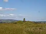 Brightworthy Barrows on Withypool Common | [54] |
| Burrow Farm iron mine and section of mineral railway trackbed, 350 m north east of Burrow Farm | Brompton Regis | Mine workings | 1863 | ST 00963 34490 51°06′04″N 3°24′57″W | The remains of Mine workings from a 19th century Iron ore mine, including the standing beam engine house. The West Somerset Mineral Railway was built to carry the ore from the Brendon Hills to Watchet for export. | 1021353 | [55] | |
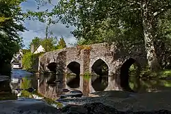
| Bury Bridge | Brompton Regis | Packhorse bridge | Middle Ages | SS 94467 27456 51°02′12″N 3°30′23″W | A medieval stone bridge with four arches, carrying a small track over the River Haddeo. | 1006242 | [56] | |
| Bury Castle | Brompton Regis | Hillfort | Iron Age reused in Middle Ages | SS 93841 26966 51°01′56″N 3°30′54″W | Bury Castle is an Iron Age Hillfort and 12th century castle. The hillfort covers 0.2 hectares (0.49 acres) in internal area. The main enclosure has a single rampart and ditch, with steep drops on the north, east and south sides. There is an additional rampart 30 metres (98 ft) to the west, with a deep ditch. The rampart is revetted with drystone walling. In the late 1130s, a civil war, known as the Anarchy, broke out in England between the supporters of King Stephen and the Empress Matilda. A motte and bailey castle was built on the Bury Castle side, probably by William de Say. In 1198 Richard I confirmed that Brompton should be part of the inheritance of Matilda. The motte measures 23 metres (75 ft) and was placed on the southern tip of the promontory, with the bailey beyond around 60 metres (197 ft) across. | 1006170 | [57][58] [59][60] | |
| Bury Castle, an Iron Age defended settlement | Selworthy | Enclosure | Iron Age | SS 91744 47171 51°12′48″N 3°33′05″W | An enclosure covering 0.21 hectares (0.52 acres) surrounded by a bank and ditch. | 1008808 | 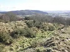 Bury Castle, an Iron Age defended settlement | [61] |
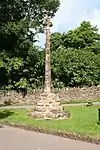
| Butter Cross at Dunster | Dunster | Wayside Cross | Late 14th or early 15th century | SS9881243873 51°11′06″N 3°26′57″W | The Butter Cross has an octagonal base and polygonal shaft which probably date from the 15th century. The cross once stood in the High Street, possibly near the Yarn Market, and was moved to its current location on the edge of the village possibly in 1825, however a drawing by J. M. W. Turner made in 1811 suggests it was in its present position by then. | 1014409 | [62][63] [64][65] [66] | |
| Cairn 90 m SSE of the Ordnance Survey triangulation point on Beacon Hill | West Quantoxhead | Cairn | Bronze Age | ST 12493 40909 51°09′39″N 3°15′10″W | The cairn is around 5.5 metres (18 ft) in diameter and 0.7 metres (2 ft 4 in) high. It is part of a wider cemetery with both cairns and round barrows. | 1014123 | Upload Photo | [67] |
| Cairn 150 m SSE of the Ordnance Survey triangulation point on Beacon Hill | West Quantoxhead | Cairn | Bronze Age | ST 12543 40858 51°09′37″N 3°15′07″W | The cairn is around 0.5 metres (1 ft 8 in) high, 6 metres (20 ft) north to south and 7 metres (23 ft) from east to west. It is part of a wider cemetery with both cairns and round barrows. | 1014124 | Upload Photo | [68] |
| Cairn 250 m SSE of the Ordnance Survey triangulation point on Beacon Hill | West Quantoxhead | Cairn | Bronze Age | ST 12575 40764 51°09′34″N 3°15′06″W | The cairn is around 12 metres (39 ft) in diameter and 0.2 metres (7.9 in) high. It is part of a wider cemetery with both cairns and round barrows. | 1014127 | Upload Photo | [69] |
| Cairn 480 m north of Little Quantock Farm | Crowcombe | Cairn | Bronze Age | ST 14915 36972 51°07′33″N 3°13′02″W | An irregular mound around 26 metres (85 ft) in diameter and 2 metres (6 ft 7 in) high. | 1017294 | Upload Photo | [70] |
| Cairn 850 m north east of Dunkery Bridge | Cutcombe | Cairn | Bronze Age | SS 90127 41213 51°09′35″N 3°34′23″W | The cairn is around 14 metres (46 ft) in diameter and 1.5 metres (4 ft 11 in) high. | 1020829 | Upload Photo | [71] |
| Cairn on Bossington Hill, 1.12 km north east of Lynch Mead | Bossington | Cairn | Bronze Age | SS 90839 48625 51°13′35″N 3°33′54″W | The cairn is around 12 metres (39 ft) in diameter and 10.9 metres (36 ft) high. | 1020795 | 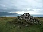 Cairn on Bossington Hill, 1.12 km north east of Lynch Mead | [72] |
| Cairn on Thorncombe Hill, 990 m north west of Halsway Post | Bicknoller | Cairn | Bronze Age | ST 13212 39105 51°08′41″N 3°14′32″W | The cairn is around 0.7 metres (2 ft 4 in) high, 11.6 metres (38 ft) north to south and 10.7 metres (35 ft) from east to west. | 1015080 | Upload Photo | [73] |
| Cairn on Thorncombe Hill | Bicknoller | Cairn | Bronze Age | ST 12679 39310 51°08′47″N 3°14′59″W | The cairn is around 0.75 metres (2 ft 6 in) high, 13 metres (43 ft) north to south and 17 metres (56 ft) from east to west. | 1014128 | Upload Photo | [74] |
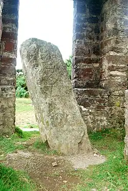
| Caratacus Stone: an inscribed stone 140 m east of Spire Cross | Winsford | inscribed stone | 6th century | SS 88970 33557 51°05′26″N 3°35′12″W | The Caratacus Stone, sometimes known as the Caractacus Stone, is an inscribed stone thought to date from the 6th century. The inscription, in Latin, can be translated as "grandson or immediate descendant of Caratacus", has led to the general opinion that the stone was probably erected as a memorial to a person who claimed the first-century British chieftain Caratacus as an ancestor. The first mention of the stone was in 1219, when it was described in a perambulation of the Royal Forest of Exmoor as "the Langeston". In 1890 the letter N (which is reversed) was missing from the inscription, but by 1919 the missing piece had been found and was cemented back in place. In 1906 a shelter was erected over the stone, and an excavation in 1937 revealed that the stone was not associated with a burial site. | 1021228 | [75][76] [77][78] | |
| Carnarvon New Pit iron mine and section of mineral railway trackbed, 300 m south west of Heather House | Brompton Regis | Mine workings | 1860s | ST 02057 34260 51°05′57″N 3°24′01″W | The remains of the Carnarvon New Pit iron mine and a section of the West Somerset Mineral Railway which served it. The mine was worked in the 1860s and 1870s before being closed as uneconomic. The ruin of the winding house, main shaft, two airshafts and parts of the railway infrastructure. | 1021352 | [79] | |
| Chains Valley stone alignment 400 m north west of Exe Head | Exmoor | Stone row | Late Neolithic to middle Bronze Age | SS 74915 41775 51°09′41″N 3°47′25″W | Ten standing and four recumbent stones which are between 120 millimetres (4.7 in) and 630 millimetres (25 in) high. | 1014278 | Upload Photo | [80] |
| Churchyard cross | Bicknoller | Cross | Late 14th century | ST 11106 39428 51°08′50″N 3°16′20″W | The cross was built in the late 14th century. The tapering octagonal shaft is supported by a three-step base. | 1006202 | [81] | |
| Churchyard cross immediately south of Holy Ghost Church | Crowcombe | Cross | Middle Ages | ST 14069 36694 51°07′23″N 3°13′45″W | The remains of a medieval cross. The octagonal 2.8 metres (9 ft 2 in) high shaft sits on a base of three steps. | 1017221 | [82] | |
| Cist and associated mound in Langridge Wood, 410 m north west of Treborough Lodge | Withycombe | Cist | Bronze Age | ST 01407 37330 51°07′36″N 3°24′37″W | A stone built rectangular cist, approximately 2 metres (6 ft 7 in) long which contained a human skeleton until it was removed in 1820. | 1020689 | .jpg.webp) Cist and associated mound in Langridge Wood, 410 m north west of Treborough Lodge | [83] |
| Clatworthy hillfort | Clatworthy | Hillfort | Iron Age | ST 04586 31500 51°04′28″N 3°22′02″W | Clatworthy Camp is an Iron Age Hillfort. It is situated on a promontory of the Brendon Hills above Clatworthy Reservoir. It is roughly triangular in shape with an area of 5.8 hectares (14 acres). It has a single bank and ditch, cut through solid rock. There may have been an entrance on the west and two on the east. | 1006149 | Upload Photo | [84] [85] |
| Cleeve Abbey | Washford | Remains of Cistercian abbey | 1198 | ST0474440703 51°09′27″N 3°21′49″W | Cleeve Abbey was a medieval monastery. The abbey was founded in the late twelfth century as a house for monks of the austere Cistercian order. In 1536 Cleeve was closed by Henry VIII in the course of the Dissolution of the Monasteries and the abbey was converted into a country house. Subsequently, the status of the site declined and the abbey was used as farm buildings until the latter half of the nineteenth century when steps were taken to conserve the remains. In the twentieth century Cleeve was taken into state care; the abbey is now looked after by English Heritage and is open to the public. While the church is no longer standing, the conventual buildings are still roofed and habitable and contain many features of particular interest including the 'angel' roof in the refectory and the wall paintings in the painted chamber. | 1014824 | [86][87] [88][89] | |
| Cow Castle | Exmoor | Hillfort | Iron Age | SS 79437 37350 51°07′22″N 3°43′27″W | Cow Castle is an Iron Age Hillfort which occupies an isolated hilltop and has a single rampart and ditch, enclosing 0.9 hectares (2.2 acres). It is in the valley of the River Barle. It has been added to the heritage at Risk register because of the risk from bracken. | 1002955 | [90][91] | |
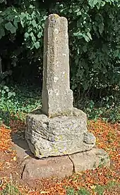
| Cross 15 m north of St Peter's Church | Williton | Cross | 13th century | ST 07522 40772 51°07′05″N 3°24′54″W | The base and lower part of the shaft of a 13th century stone cross. | 1017293 | [92] | |
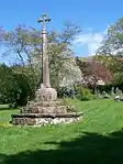
| Cross in the churchyard of All Saints' Church | Selworthy | Cross | Late 14th century | SS 91995 46793 51°12′37″N 3°32′51″W | A medieval cross with a 2-metre (6 ft 7 in) stone shaft on an octagonal base with three octagonal steps. | 1020775 | [93][94] [95] | |
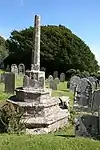
| Cross in the churchyard of St George's Church | Dunster | Cross | Middle Ages | SS 98995 43662 51°11′00″N 3°26′47″W | The remains of a stone cross which was constructed in or before the 15th century. The remaining part of the shaft is 0.5 millimetres (0.020 in) high and sits on a circular base with three steps. | 1021061 | [96] | |
| Cross in the churchyard of the Church of St Mary the Virgin | Luccombe | Cross | 15th century | SS 91118 44531 51°11′22″N 3°33′34″W | A 15th century cross with a 1 metre (3 ft 3 in) stone shaft set in an octagonal three step base. | 1020917 | [97] | |
| Cross in the churchyard of St Mary the Virgin's Church | Nettlecombe | Cross | Late 14th century | ST 05696 37742 51°07′52″N 3°20′57″W | The remains of a 14th century cross with a stone shaft set in a two-step base. | 1020691 | Upload Photo | [98] |
| Cross in the churchyard of St Peter's Church | Exton | Cross | Late 14th century | SS 92585 33693 51°05′33″N 3°32′07″W | The remains of a 14th century cross with a tapering octagonal stone shaft. The upper part of the shaft was restored in 1875. | 1021156 | Upload Photo | [99] |
| Cross in the churchyard of the Church of St Decuman | Watchet | Cross | 14th or 15th century | ST 06493 42684 51°10′47″N 3°19′49″W | The remains of a 14th or 15th century cross with a tapering octagonal stone shaft on an octagonal base. The upper part of the shaft was restored with wood in the mid 20th century. | 1020919 | [100] | |
| Cross in the churchyard of St Mary's Church | Luxborough | Cross | 13th or 14th century | SS 97385 38005 51°07′56″N 3°28′04″W | A medieval inscribed stone cross which is 1.6 metres (5 ft 3 in) high and stands on a partially buried plinth. | 1021155 | Upload Photo | [101] |
| Cross in the churchyard of St Peter's Church | Treborough | Cross | Late 13th century | ST 01067 36365 51°07′05″N 3°24′54″W | A medieval cross with a stone shaft on an octagonal base with three octagonal steps. The head of the cross with a figure of St Peter is a 19th century addition. | 1020690 | [102] | |
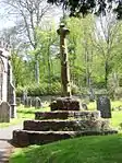
| Crowcombe village cross 170 m north west of Holy Ghost Church | Crowcombe | Cross | Middle Ages | ST 13906 36765 51°07′25″N 3°13′54″W | A medieval cross of red sandstone. The octagonal shaft is 3 metres (9.8 ft) high, topped by a Greek cross added in the 19th century, standing on an octagonal base. | 1017220 | [103] | |
| Curdon Wood camp | Stogumber | Hillfort | Iron Age | ST 10201 38515 51°08′05″N 3°17′28″W | Curdon Camp is a univallate Iron Age hillfort. It was nearly completely destroyed by quarrying and bulldozing. A section of the camp remains that is still 2.5 metres (8 ft 2 in) high on the southern and western sides. | 1006158 | Upload Photo | [104][105] |
| Daw's Castle | Watchet | Hillfort | Iron Age | ST 06141 43181 51°10′53″N 3°20′39″W | Daw's Castle is a sea cliff Hillfort just west of Watchet. The fort is situated on an east-west cliff about 80 metres (260 ft) above the sea, on a tapering spur of land bounded by the Washford River. The ramparts of the fort would have formed a semicircle backing on to the sheer cliffs, but coastal erosion has reduced the size of the enclosure, and later destruction by farming, limekilns, and the B3191 road, have left only about 300 metres (980 ft) of ramparts visible today. The fort may be of Iron Age origin, but was (re)built and fortified as a burh by King Alfred, as part of his defence against Viking raids from the Bristol Channel around 878 AD. It would have been one of a chain of forts and coastal lookout posts, connected by the Herepath, or military road, which allowed Alfred to move his army along the coast, covering Viking movements at sea. | 1020882 | [106][107] | |
| Deserted medieval farm, W of Bramble Combe | Minehead Without | Earthworks | Middle Ages | SS 94045 47920 51°13′14″N 3°31′07″W | Earthworks of a medieval farmhouse 22 metres (72 ft) by 5 metres (16 ft). It is known to have been occupied around 1279 and in decline by 1487. | 1006126 | Upload Photo | [108] |
| Dovecote 60 m north of St George's Church | Dunster | Dovecote | Late 16th century | SS9901843725 51°11′02″N 3°26′46″W | Dunster Dovecote was probably built in the late 16th century. It is situated on Priory Green opposite the Tithe Barn and close to the walls of the Priory Church of St George. It is approximately 5.8 metres (19 ft) high and 5.8 metres (19 ft) in diameter, with walls around 1.2 metres (4 ft) thick. There are five hundred and forty nest-holes. In the 18th century the floor level and door were raised among several major alterations. The lower tiers of nest holes were blocked to protect against Brown Rats which had arrived in the Britain in 1720 and reached Somerset by 1760. A revolving ladder, known as a "potence", was installed to allow the pigeon keeper to search the nest holes more easily. In the 19th century two feeding platforms were added to the axis of the revolving ladder. | 1020408 | [109][110][111][112] | |
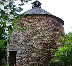
| Dovecote at Little Blackford | Selworthy | Dovecote | 11th century | SS 92475 45284 51°11′48″N 3°32′25″W | The Dovecot At Blackford Farm was built in the 11th century. It is now owned by the National Trust and used as a store for the neighbouring farm. The earliest written record of the Dovecote was in 1393 although the exact date of construction is not known. It is built of local Devonian sandstone, with walls are 1.2 metres (4 ft) thick and contains over 300 nest holes. | 1020774 | [113][114][115] | |
| Doverhay Down round barrow, Porlock | Luccombe | Round barrow | Bronze Age | SS 88566 45241 51°11′44″N 3°35′46″W | Two round barrows one of which is 9.6 metres (31 ft) in diameter and the other 6.4 metres (21 ft). | 1006191 | Upload Photo | [116] |
| Dowsborough hillfort and associated round barrow | Holford | Hillfort | Iron Age | ST 16017 39113 51°08′43″N 3°12′05″W | Dowsborough Camp (or Danesborough or Dawesbury) is an Iron Age Hillfort on the Quantock Hills near Nether Stowey. The fort has an oval shape, with a single rampart and ditch (univallate) following the contours of the hill top, enclosing an area of 2.7 hectares (6.7 acres). The fort and associated round barrow has been added to the Heritage at Risk Register due to vulnerability to vehicle damage and erosion. | 1010494 | Upload Photo | [117][118] [119][120] |
| Dunkery Beacon and adjacent mounds | Cutcombe | Burial mounds | Bronze Age | SS 89143 41590 51°09′46″N 3°35′12″W | Dunkery Beacon is the summit of Dunkery Hill, and the highest point on Exmoor and in Somerset. Dunkery Beacon was given to the National Trust in 1935 by Sir Thomas Acland, Colonel Wiggin and Allan Hughes along with the rest of the Holnicote Estate an event commemorated by the summit memorial cairn known as Robin How. | 1003026 | [121][122] | |
| Early Christian to medieval settlement and cemetery | Carhampton | Earthworks | Early Middle Ages | ST 01108 42677 51°10′29″N 3°24′58″W | Earthworks remains of houses and a metal working site dating from the 5th to 8th century. Skeletons from a medieval cemetery have also been recovered from the site. | 1013589 | Upload Photo | [123] |
| Earthwork enclosure on Rodhuish Common, 300 m west of Moor Barn | Withycombe | Hillfort | Iron Age | SS 99901 39225 51°08′37″N 3°25′56″W | Rodhuish Common is a univallate Iron Age Hillfort. There is a small oval enclosure which is thought to be of Iron Age date. | 1021122 | Upload Photo | [124][125] |
| Earthwork enclosure on Monkslade Common, 860 m east of Fire Tower | Luxborough | Earthworks | Iron Age | SS 99468 39174 51°08′35″N 3°26′19″W | Earthworks from an Iron Age enclosure 68 metres (223 ft) long and 54 metres (177 ft) wide surrounded by a bank and ditch. | 1021121 | Upload Photo | [126] |
| Earthwork enclosure on Winsford Hill, 200 m south east of Wambarrows | Winsford | Earthworks | Late Middle Ages | SS 87789 34204 51°05′46″N 3°36′14″W | Earthworks from a medieval enclosure 17.6 metres (58 ft) long and 13.2 metres (43 ft) wide. | 1021274 | Upload Photo | [127] |
| Earthworks W of Bury | Brompton Regis | Earthworks | Unknown | SS9434027296 51°02′07″N 3°30′30″W | Earthworks from an enclosure of unknown date with banks on either side; however it is unlikely this was a defensive structure. | 1003031 | Upload Photo | [128] |
| East Pinford: a stone alignment on the west side of East Pinford 700 m west of Long Combe sheep pen | Exmoor | Stone row | Late Neolithic to middle Bronze Age | SS 79658 42730 51°10′16″N 3°43′22″W | An alignment of two parallel rows of six standing stones. The stones are between 350 millimetres (14 in) and 720 millimetres (28 in) high. | 1014263 | Upload Photo | [129] |
| Edgerley Stone | Exmoor | Inscribed stone | Before 1207 | SS 71959 40700 51°09′04″N 3°49′56″W | A wedge shaped stone which is 1.5 metres (4 ft 11 in) high. The inscribed text is of unknown date. | 1020883 | Upload Photo | [130] |
| Elworthy Barrows hillfort | Brompton Ralph | Hill fort | Iron Age | ST 07033 33718 51°05′44″N 3°19′43″W | Elworthy Barrows is an unfinished Iron Age hill fort rather than Bronze Age barrows. It covers an area of 3.5 hectares (8.6 acres) and is surrounded by a bank and ditch. | 1020724 | Upload Photo | [131][132][133] |
| Enclosure and associated outworks on Staddon Hill | Winsford | Enclosure | Iron Age | SS 88143 37524 51°07′34″N 3°35′59″W | Staddon Hill Camp is an hill slope enclosure. It covers 0.1 hectares (0.25 acres) and is surrounded by a bank and ditch. | 1021359 | Upload Photo | [134] |
| Entrenchment on Heydon Hill | Huish Champflower | Earthworks | Unknown | ST 03391 28215 51°02′42″N 3°22′46″W | A bank and ditch. The site has been added to the Heritage at Risk Register because of the risks of arable ploughing. | 1006173 | Upload Photo | [135][136] |
| Exe Plain stone alignment 425 m north east of the sheepfold | Exmoor | Stone row | Late Neolithic to middle Bronze Age | SS 74970 42629 51°10′09″N 3°47′23″W | A 27.8-metre (91 ft) long stone row of two vertical and one recumbent stones. | 1014262 | Upload Photo | [137] |
| Four cairns on Hurley Beacon | Crowcombe | Cairn | Bronze Age | ST 14112 37999 51°08′05″N 3°13′44″W | The central cairn at the highest point is known as Hurley Beacon and is 24 metres (79 ft) in diameter and 2 metres (6 ft 7 in) high. | 1017218 | Upload Photo | [138] |
| Four medieval fish weirs 500 m east of the Harbour | Minehead | Fishing weir | Middle Ages | SS 97644 47052 51°12′49″N 3°28′00″W | A series of V shaped stone fish weirs. The date on which they were built is not documented however there is documentary evidence of the weirs in the 1420, but they may date back to the 11th century. | 1020017 | Upload Photo | [139] |
| Four round barrows on The Allotment, 520 m south east of Spire Cross | Winsford | Round barrow | Neolithic to Bronze Age | SS 89284 33287 51°05′18″N 3°34′56″W | Four round barrows each between 5 metres (16 ft) and 12.5 metres (41 ft) in diameter. | 1021230 | Upload Photo | [140] |
| Four round cairns on Dunkery Hill 400 m south east of Joaney How Cairn | Wootton Courtenay | Cairn | Bronze Age | SS 91052 42642 51°10′21″N 3°33′35″W | Two pairs of cairns ranging from 7.4 metres (24 ft) to 18 metres (59 ft) in diameter. | 1020931 | Upload Photo | [141] |
| Gallox Bridge | Dunster | Bridge | 15th century | SS9895143213 51°10′45″N 3°26′49″W | The Gallox Bridge is a narrow stone packhorse bridge, on the southern outskirts of Dunster, with two arches over the River Avill. It has a roadway width of 1.2 metres (3.9 ft), a total width of 1.9 metres (6.2 ft) and is 13.5 metres (44.3 ft) long. The bridge is in the guardianship of English Heritage. | 1014410 | [142][143] | |
| Green Barrow on Hawkridge Common | Withypool and Hawkridge | Bowl barrow | Neolithic to Bronze Age | SS 81791 34564 51°05′54″N 3°41′23″W | A 13.3-metre (44 ft) diameter bowl barrow. | 1021263 | Upload Photo | [144] |
| Group of four barrows and cairns known as 'Rowbarrows' including Great Rowbarrow and Little Rowbarrow | Cutcombe | Cairns and barrows | Bronze Age | SS 87417 41473 51°09′41″N 3°36′41″W | A cairn which is 25 metres (82 ft) diameter and associated barrows. | 1003677 | .jpg.webp) Group of four barrows and cairns known as 'Rowbarrows' including Great Rowbarrow and Little Rowbarrow | [145][146] |
| Group of round barrows | North Molton | Round barrow | Bronze Age | SS 74635 36212 51°06′41″N 3°47′32″W | A group of ten Round barrows | 1002626 | .jpg.webp) Group of round barrows | [147] |


.jpg.webp)


.jpg.webp)
.jpg.webp)


See also
- Scheduled monuments in West Somerset – overview of scheduled monuments
- Scheduled monuments in West Somerset (H–Z) – list of scheduled monuments
- Scheduled monuments in Taunton Deane – overview and list of scheduled monuments
Notes
- The date given is the date used by Historic England as significant for the initial building or that of an important part in the structure's description.
- Sometimes known as OSGB36, the grid reference is based on the British national grid reference system used by the Ordnance Survey.
- The "List Entry Number" is a unique number assigned to each listed building and scheduled monument by Historic England.
References
- "Agnes Fountain". National Heritage List for England. Historic England. Archived from the original on 8 December 2014. Retrieved 23 November 2014.
- "MSO6730 - Alderman's Barrow, Almsworthy Common". Exmoor National Park Historic Environment Record. Exmoor National Park. Retrieved 23 November 2014.
- "Allerford New Bridge". National Heritage List for England. Historic England. Archived from the original on 8 December 2014. Retrieved 23 November 2014.
- "MSO8006 - New Bridge, Allerford". Exmoor National Park Historic Environment Record. Exmoor National Park. Retrieved 23 November 2014.
- Historic England. "Packhorse Bridge (1058014)". National Heritage List for England. Retrieved 5 January 2008.
- "Almsworthy Common: a stone alignment 560 m south west of Chetsford Bridge". National Heritage List for England. Historic England. Archived from the original on 8 December 2014. Retrieved 23 November 2014.
- "Bagley Iron Age defended settlement enclosure and deserted medieval farm". National Heritage List for England. Historic England. Archived from the original on 8 December 2014. Retrieved 23 November 2014.
- "MSO9331 - Barle Bridge, Dulverton". Exmoor National Park Historic Environment Record. Exmoor National Park. Retrieved 23 November 2014.
- Historic England. "Barlynch Priory (36537)". Research records (formerly PastScape). Retrieved 24 January 2015.
- "Houses of Augustinian canons: The priory of Barlynch". Houses of Augustinian canons: The priory of Barlynch', A History of the County of Somerset: Volume 2 (1911), pp. 132-134. British History Online. Retrieved 12 July 2009.
- Historic England. "Barlich Farmhouse (1237516)". National Heritage List for England. Retrieved 12 July 2009.
- "Barlinch Priory, Brompton Regis, West Somerset - Exmoor (NP)". Heritage at Risk. Historic England. Retrieved 20 October 2013.
- "Barrow and cairn cemetery on Black Hill, 490 m north west of Crowcombe Park Gate". National Heritage List for England. Historic England. Archived from the original on 8 December 2014. Retrieved 23 November 2014.
- "Barrow at Wilmot's Pool and a cairn 45 m to the north". National Heritage List for England. Historic England. Archived from the original on 8 December 2014. Retrieved 23 November 2014.
- Historic England. "Monument No. 189871". Research records (formerly PastScape). Retrieved 11 January 2015.
- Historic England. "Monument No. 189876". Research records (formerly PastScape). Retrieved 11 January 2015.
- "Bat's Castle: a small multivallate hillfort and associated outwork". National Heritage List for England. Historic England. Archived from the original on 20 June 2014. Retrieved 28 February 2015.
- "Bats Castle". Crown Estates. Archived from the original on 17 July 2014. Retrieved 20 November 2010.
- "Bat's Castle, Gallox Hill, Carhampton". Exmoor Historic Environment Record. English Heritage. Retrieved 21 March 2011.
- Bush, Robin (1994). Somerset: The complete guide. Wimborne, Dorset: Dovecote Press. pp. 55. ISBN 1-874336-26-1.
- "Beckham stone alignment and mound, 450 m south east of the Long Combe sheep pen". National Heritage List for England. Historic England. Archived from the original on 8 December 2014. Retrieved 23 November 2014.
- Historic England. "Bendels Barrows (35944)". Research records (formerly PastScape). Retrieved 23 November 2014.
- "MSO6716 - Bendels Barrows, Exford Common, Exford". Exmoor National Park Historic Environment Record. Exmoor National Park. Retrieved 23 November 2014.
- Historic England. "Berry Castle (35939)". Research records (formerly PastScape). Retrieved 14 May 2011.
- "Berry Castle". Exmoor National Park Historic Environment Record. English Heritage. Retrieved 14 May 2011.
- "Black Ball Camp: a later prehistoric defended settlement on Gallox Hill". National Heritage List for England. Historic England. Archived from the original on 20 June 2014. Retrieved 28 February 2015.
- "Black Ball Camp". Exmoor Historic Environment Record. English Heritage. Retrieved 21 March 2011.
- "Black Ball Camp". Somerset Historic Environment Record. Somerset County Council. Retrieved 15 November 2010.
- "Black Ball Camp". Exmoor Historic Environment Record. English Heritage. Retrieved 21 March 2011.
- "MSO7900 - Black Barrow". Exmoor National Park Historic Environment Record. Exmoor National Park. Retrieved 23 November 2014.
- "Bowl barrow 80 m north of Halsway Post". National Heritage List for England. Historic England. Archived from the original on 8 December 2014. Retrieved 23 November 2014.
- "Bowl barrow 100 m north west of Halsway Post". National Heritage List for England. Historic England. Archived from the original on 8 December 2014. Retrieved 23 November 2014.
- "Bowl barrow 122 m NNW of Halsway Post". National Heritage List for England. Historic England. Archived from the original on 8 December 2014. Retrieved 23 November 2014.
- "Bowl barrow 225 m north west of Halsway Post". National Heritage List for England. Historic England. Archived from the original on 8 December 2014. Retrieved 23 November 2014.
- "Bowl barrow 260 m north east of Ralegh's Cross Hotel". National Heritage List for England. Historic England. Archived from the original on 8 December 2014. Retrieved 23 November 2014.
- "Bowl barrow 470 m north of Brendon Hill Farm". National Heritage List for England. Historic England. Archived from the original on 8 December 2014. Retrieved 23 November 2014.
- "Bowl barrow 610 m ESE of the fire tower on Monkham Hill". National Heritage List for England. Historic England. Archived from the original on 8 December 2014. Retrieved 23 November 2014.
- "Bowl barrow 650 m north west of Elworthy Barrows hillfort". National Heritage List for England. Historic England. Archived from the original on 8 December 2014. Retrieved 23 November 2014.
- "Bowl barrow 700 m north east of Burrow Farm". National Heritage List for England. Historic England. Archived from the original on 8 December 2014. Retrieved 23 November 2014.
- "Bowl barrow 780 m ESE of the fire tower on Monkham Hill". National Heritage List for England. Historic England. Archived from the original on 8 December 2014. Retrieved 23 November 2014.
- "Bowl barrow and round cairn on Withypool Hill, 850 m and 820 m east of Portford Bridge". National Heritage List for England. Historic England. Retrieved 28 February 2015.
- "Bowl barrow called Chains Barrow". National Heritage List for England. Historic England. Archived from the original on 8 December 2014. Retrieved 23 November 2014.
- "Bowl barrow on Longstone Hill, 270 m NNE of Bicknoller Post". National Heritage List for England. Historic England. Archived from the original on 8 December 2014. Retrieved 23 November 2014.
- "Bowl barrow on Longstone Hill, 270 m north east of Bicknoller Post". National Heritage List for England. Historic England. Retrieved 6 March 2015.
- "Bowl barrow on Lype Hill, 550 m north west of Lype Farm". National Heritage List for England. Historic England. Archived from the original on 8 December 2014. Retrieved 23 November 2014.
- "Bowl barrow on Lype Hill, 750 m ENE of Heath Pault Cross". National Heritage List for England. Historic England. Archived from the original on 8 December 2014. Retrieved 23 November 2014.
- "Bowl barrow on Thorncombe Hill". National Heritage List for England. Historic England. Archived from the original on 8 December 2014. Retrieved 23 November 2014.
- "Bowl barrow on Thorncombe Hill, 1.03 km north east of Paradise Farm". National Heritage List for England. Historic England. Archived from the original on 8 December 2014. Retrieved 23 November 2014.
- "Bowl barrow on Thorncombe Hill, 1.07 km north east of Paradise Farm". National Heritage List for England. Historic England. Archived from the original on 8 December 2014. Retrieved 23 November 2014.
- "Bowl barrow on Thorncombe Hill 500 m north west of Halsway Post". National Heritage List for England. Historic England. Archived from the original on 8 December 2014. Retrieved 23 November 2014.
- "Bowl barrow on Thorncombe Hill known as `Thorncombe Barrow'". National Heritage List for England. Historic England. Archived from the original on 8 December 2014. Retrieved 23 November 2014.
- "Bowl barrow on Weacombe Hill, 300 m SSW of Bicknoller Post". National Heritage List for England. Historic England. Retrieved 28 February 2015.
- "Brewer's Castle". National Heritage List for England. Historic England. Archived from the original on 2 May 2014. Retrieved 23 November 2014.
- "Brightworthy Barrows on Withypool Common". National Heritage List for England. Historic England. Archived from the original on 8 December 2014. Retrieved 23 November 2014.
- "Burrow Farm iron mine and section of mineral railway trackbed, 350 m north east of Burrow Farm". National Heritage List for England. Historic England. Archived from the original on 8 December 2014. Retrieved 23 November 2014.
- "MSO8842 - Bury Bridge, Bury, Brompton Regis". Exmoor National Park Historic Environment Record. Exmoor National Park. Retrieved 23 November 2014.
- Historic England. "Bury Castle (36765)". Research records (formerly PastScape). Retrieved 21 March 2011.
- "Bury Castle, an Iron Age defended settlement, No:24025". Somerset Historic Environment Record. Somerset County Council. Retrieved 16 July 2011.
- Bury Castle, Brompton Regis, Gatehouse website, accessed 16 July 2011.
- Dunning, Robert (1995). Somerset Castles. Tiverton: Somerset Books. pp. 30–31. ISBN 978-0-86183-278-1.
- "Bury Castle, an Iron Age defended settlement". National Heritage List for England. Historic England. Archived from the original on 2 May 2014. Retrieved 3 March 2015.
- "Butter Cross". National heritage list for England. Historic England. Archived from the original on 14 July 2014. Retrieved 14 July 2013.
- "Butter Cross at Dunster — ancient monument". National Heritage List for England. Historic England. Archived from the original on 14 July 2014. Retrieved 15 June 2014.
- "Butter Cross, Dunster". Exmoor Historic Environment Record. Exmoor National Park.
- "History and Research: Dunster Butter Cross". Retrieved 25 March 2015.
- "Dunster: The Butter Cross, St George's Church, the Castle and Conygar Tower". TATE. Retrieved 25 March 2015.
- "Cairn 90 m SSE of the Ordnance Survey triangulation point on Beacon Hill". National Heritage List for England. Historic England. Retrieved 25 November 2014.
- "Cairn 150 m SSE of the Ordnance Survey triangulation point on Beacon Hill". National Heritage List for England. Historic England. Retrieved 25 November 2014.
- "Cairn 250 m SSE of the Ordnance Survey triangulation point on Beacon Hill". National Heritage List for England. Historic England. Retrieved 25 November 2014.
- "Cairn 480 m north of Little Quantock Farm". National Heritage List for England. Historic England. Retrieved 25 November 2014.
- "Cairn 850 m north east of Dunkery Bridge". National Heritage List for England. Historic England. Retrieved 25 November 2014.
- "Cairn on Bossington Hill, 1.12 km north east of Lynch Mead". National Heritage List for England. Historic England. Retrieved 25 November 2014.
- "Cairn on Thorncombe Hill, 990 m north west of Halsway Post". National Heritage List for England. Historic England. Retrieved 25 November 2014.
- "Cairn on Thorncombe Hill". National Heritage List for England. Historic England. Retrieved 25 November 2014.
- Historic England. "Caratacus Stone (35777)". Research records (formerly PastScape). Retrieved 3 June 2011.
- Thomas, Charles (1994). And Shall These Mute Stones Speak? Post Roman Inscriptions in Western Britain. University of Wales Press. pp. 288–9. ISBN 0-7083-1160-1.
- "Caratacus Stone". National heritage list for England. Historic England. Archived from the original on 8 December 2014. Retrieved 9 June 2013.
- Bruton, F. A. (1919). "The Caratacus Stone on Exmoor" (PDF). The Journal of Roman Studies. 9: 208–210. doi:10.2307/296006.
- "Carnarvon New Pit iron mine and section of mineral railway trackbed, 300 m south west of Heather House". National Heritage List for England. Historic England. Archived from the original on 29 October 2013. Retrieved 25 November 2014.
- "Chains Valley stone alignment 400 m north west of Exe Head". National Heritage List for England. Historic England. Retrieved 25 November 2014.
- "Churchyard Cross, 8 metres East of chancel, Church of St George, Church Lane (South side), Bicknoller". Somerset Historic Environment Record. Somerset County Council. Retrieved 25 November 2014.
- "Churchyard cross immediately south of Holy Ghost Church". National Heritage List for England. Historic England. Retrieved 28 February 2015.
- "Cist and associated mound in Langridge Wood, 410 m north west of Treborough Lodge". National Heritage List for England. Historic England. Retrieved 25 November 2014.
- "Clatworthy Camp". Somerset Historic Environment Record. Somerset County Council. Retrieved 22 March 2011.
- Historic England. "Clatworthy Camp (188442)". Research records (formerly PastScape). Retrieved 22 March 2011.
- "Cleeve Abbey". Historic England. Archived from the original on 14 July 2014. Retrieved 9 August 2013.
- William Page, ed. (1911). "House of Cistercian monks: The abbey of Cleeve". A History of the County of Somerset: Volume 2. Institute of Historical Research. Retrieved 11 May 2013.
- "Cleeve Abbey, Washford". Somerset Historic Environment Record. Somerset County Council. Retrieved 13 July 2008.
- "Cleeve Abbey". Historic England. Retrieved 23 May 2013.
- "Cow Castle, Exmoor, West Somerset - Exmoor (NP)". Heritage at Risk. Historic England. Retrieved 28 October 2015.
- "Cow Castle". Exmoor National Park Historic Environment Record. English Heritage. Retrieved 16 January 2011.
- "Cross 15 m north of St Peter's Church". National Heritage List for England. Historic England. Retrieved 25 November 2014.
- Adkins, Lesley; Roy Adkins (1992). A Field Guide to Somerset Archaeology. Wimborne, Dorset: Dovecote Press. p. 101. ISBN 0-946159-94-7.
- Historic England. "Remains of churchyard cross (1058028)". National Heritage List for England. Retrieved 26 January 2008.
- "Cross in the churchyard of All Saints' Church". National Heritage List for England. Historic England. Retrieved 25 November 2014.
- "Cross in the churchyard of St George's Church". National Heritage List for England. Historic England. Retrieved 25 November 2014.
- "Cross in the churchyard of the Church of St Mary the Virgin". National Heritage List for England. Historic England. Retrieved 25 November 2014.
- "Cross in the churchyard of St Mary the Virgin's Church". National Heritage List for England. Historic England. Retrieved 25 November 2014.
- "Cross in the churchyard of St Peter's Church". National Heritage List for England. Historic England. Retrieved 25 November 2014.
- "Cross in the churchyard of the Church of St Decuman". National Heritage List for England. Historic England. Retrieved 25 November 2014.
- "Cross in the churchyard of St Mary's Church". National Heritage List for England. Historic England. Retrieved 25 November 2014.
- "Cross in the churchyard of St Peter's Church". National Heritage List for England. Historic England. Retrieved 25 November 2014.
- "Crowcombe village cross 170 m north west of Holy Ghost Church". National Heritage List for England. Historic England. Retrieved 25 November 2014.
- "Curdon Wood Camp". Somerset Historic Environment Record. Somerset County Council. Retrieved 22 March 2011.
- Historic England. "Curdon Camp (189556)". Research records (formerly PastScape). Retrieved 22 March 2011.
- Historic England. "Daws Castle (188490)". Research records (formerly PastScape). Retrieved 16 March 2011.
- "Daws Castle, Watchet". Somerset Historic Environment Record. Somerset County Council. Retrieved 14 January 2011.
- "MMO213 - Deserted medieval farmstead on western side of Bramble Combe". Exmoor National Park Historic Environment Record. Exmoor National Park. Retrieved 30 November 2014.
- "Dovecote". National heritage list for England. Historic England. Archived from the original on 29 November 2014. Retrieved 17 July 2013.
- Ballard, Barbara. "Dunster Somerset". Britain Express. Retrieved 4 June 2009.
- Cooke, A.O. "Somerset and Devon". Book of Dovecotes. Chapter 17. Retrieved 4 June 2009.
- "Dovecote, Dunster". Somerset Historic Environment Record. Somerset County Council. Retrieved 4 June 2009.
- "Dovecot at Blackford Farm". National Heritage List for England. Historic England. Archived from the original on 2 May 2014. Retrieved 9 April 2014.
- "Dovecote at Little Blackford". Somerset Historic Environment Record. Somerset County Council. Retrieved 11 April 2014.
- "Dovecote at Little Blackford". National Heritage List for England. Historic England. Archived from the original on 2 May 2014. Retrieved 11 April 2014.
- "MSO7317 - Two Bowl Barrows, Doverhay". Exmoor National Park Historic Environment Record. Exmoor National Park. Retrieved 3 December 2014.
- "Dowsborough hillfort and associated round barrow, Holford — West Somerset". Heritage at Risk. Historic England. Retrieved 28 October 2015.
- Historic England. "Dowsborough Camp (189456)". Research records (formerly PastScape). Retrieved 23 March 2011.
- "Dowsborough hillfort, Holford". Somerset Historic Environment Record. Somerset County Council. Retrieved 28 December 2010.
- "Dowsborough hillfort and associated round barrow". National Heritage List for England. Historic England. Archived from the original on 2 May 2014. Retrieved 3 December 2014.
- "MSO9187 - Dunkery Beacon". Exmoor National Park Historic Environment Record. Exmoor National Park. Retrieved 3 December 2014.
- Historic England. "Robin How (36960)". Research records (formerly PastScape). Retrieved 3 December 2014.
- "Early Christian to medieval settlement and cemetery". National Heritage List for England. Historic England. Archived from the original on 29 January 2015. Retrieved 3 December 2014.
- "Earthwork enclosure on Rodhuish Common, 300 m west of Moor Barn". English Heritage. Archived from the original on 8 December 2014. Retrieved 24 July 2011.
- Historic England. "Rodhuish Common (1139717)". Research records (formerly PastScape). Retrieved 26 March 2011.
- "Earthwork enclosure on Monkslade Common, 860 m east of Fire Tower". National Heritage List for England. Historic England. Archived from the original on 29 January 2015. Retrieved 3 December 2014.
- "Earthwork enclosure on Winsford Hill, 200 m south east of Wambarrows". National Heritage List for England. Historic England. Archived from the original on 29 January 2015. Retrieved 3 December 2014.
- "MSO8844 - Enclosure on southern bank of River Haddeo". Exmoor National Park Historic Environment Record. Exmoor National Park. Retrieved 3 December 2014.
- "East Pinford: a stone alignment on the west side of East Pinford 700 m west of Long Combe sheep pen". National Heritage List for England. Historic England. Archived from the original on 11 December 2014. Retrieved 5 December 2014.
- "Edgerley Stone". National Heritage List for England. Historic England. Retrieved 28 February 2015.
- Historic England. "Elworthy Barrows Hillfort (188401)". Research records (formerly PastScape). Retrieved 23 March 2011.
- "Elworthy Barrows hillfort, Brompton Ralph". Somerset Historic Environment Record. Somerset County Council. Retrieved 9 March 2010.
- "Elworthy Barrows hillfort". National Heritage List for England. Historic England. Retrieved 20 November 2018.
- "Enclosure and associated outworks on Staddon Hill". National Heritage List for England. Historic England. Archived from the original on 11 December 2014. Retrieved 5 December 2014.
- "Entrenchment on Heydon Hill, Huish Champflower - West Somerset". Heritage at Risk. Historic England. Archived from the original on 11 December 2014. Retrieved 5 December 2014.
- "Linear Earthwork, Heydon Hill, Huish Champflower". Somerset Historic Environment Record. Somerset County Council. Retrieved 10 December 2014.
- "Exe Plain stone alignment 425 m north east of the sheepfold". National Heritage List for England. Historic England. Archived from the original on 11 December 2014. Retrieved 5 December 2014.
- "Four cairns on Hurley Beacon". National Heritage List for England. Historic England. Archived from the original on 11 December 2014. Retrieved 5 December 2014.
- "Four medieval fish weirs 500 m east of the Harbour". National Heritage List for England. Historic England. Retrieved 28 February 2015.
- "Four round barrows on The Allotment, 520 m south east of Spire Cross". National Heritage List for England. Historic England. Archived from the original on 11 December 2014. Retrieved 5 December 2014.
- "Four round cairns on Dunkery Hill 400 m south east of Joaney How Cairn". National Heritage List for England. Historic England. Archived from the original on 11 December 2014. Retrieved 5 December 2014.
- Historic England. "Gallox Bridge (36854)". Research records (formerly PastScape). Retrieved 24 January 2015.
- Historic England. "Gallox Bridge (1296207)". National Heritage List for England. Retrieved 13 April 2009.
- "Green Barrow on Hawkridge Common". National Heritage List for England. Historic England. Archived from the original on 13 December 2014. Retrieved 6 December 2014.
- Historic England. "Great Rowbarrow (35967)". Research records (formerly PastScape). Retrieved 27 December 2014.
- Historic England. "Monument No. 35934". Research records (formerly PastScape). Retrieved 27 December 2014.
- Historic England. "Five Barrows (35022)". Research records (formerly PastScape). Retrieved 27 December 2014.
This article is issued from Wikipedia. The text is licensed under Creative Commons - Attribution - Sharealike. Additional terms may apply for the media files.