Scheduled monuments in West Somerset (H–Z)
West Somerset was a local government district located in the English county of Somerset. It merged with Taunton Deane to form Somerset West and Taunton on 1 April 2019.
Monuments
| Name | Location | Type | Completed [note 1] | Grid ref.[note 2] Geo-coordinates | Notes | Entry number [note 3] | Image | Ref. |
|---|---|---|---|---|---|---|---|---|
| Halscombe stone setting 790 m SSW of Simonsbath Bridge | Exmoor | Standing stones | Late Neolithic to Bronze Age | SS 77022 38336 51°07′52″N 3°45′32″W | Two rows of standing stones, up to 600 millimetres (24 in) high, some of which are now recumbent. | 1014281 |  Upload Photo | [1] |
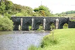
| Hillfort on Grabbist Hill, 275 m south west of St Leonard's Well | Dunster | Hillfort | Iron Age | SS 98294 43686 51°11′00″N 3°27′23″W | Grabbist hillfort is an Iron Age oval hillfort. The fort is 270.0 metres (885.8 ft) long and 219.8 feet (67.0 m) wide, and is surrounded by a counterscarp, which measures 4.2 to 6.2 feet (1.3 to 1.9 m) in height. It is also surrounded by a ditch, which ranges up to 10.0 metres (32.8 ft) wide and 2.2 metres (7.2 ft) deep. The bank has a peak height of 3 metres (9.8 ft), and, on the northern and western sides, there is a second bank, which leads to the northeastern corner being the most strongly defended. | Upload Photo | [2][3] | |
| Holy well at St Pancras Chapel | Old Cleeve | Well | Middle Ages | ST 04143 39888 51°09′01″N 3°22′18″W | A stone lined holy well in the grounds of the former St Pancras Chapel which is now a private house. | 1020720 | Upload Photo | [4] |
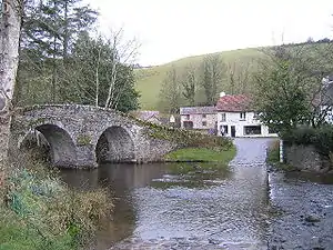
| Horner packhorse bridge | Luccombe | Packhorse bridge | Middle Ages | SS 89733 45541 51°11′54″N 3°34′47″W | A stone packhorse bridge over Horner Water. | 1006228 | 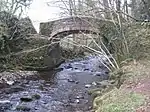 Horner packhorse bridge | [5] |
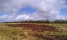
| Huish Champflower Barrow | Huish Champflower | Bowl barrow | Late Neolithic to middle Bronze Age | ST 02860 34168 51°05′55″N 3°23′19″W | A bowl barrow which is 21 metres (69 ft) in diameter. | 1020692 | .jpg.webp) Huish Champflower Barrow | [6] |
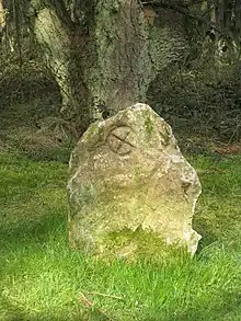
| Incised stone W of Stent Hill | Oare | Standing stone | Possibly 7th to 9th century | SS 83210 47374 51°12′49″N 3°40′24″W | The Culbone Stone, an early mediaeval standing stone approximately one metre in height. It lies in woodland close to the parish boundary, and features an incised wheeled cross, the style of which suggests it dates from 7th to 9th century. The stone is legally protected as a scheduled monument. It has been suggested that the stone has been moved from its original site as part of the Culbone Hill Stone Row. | 1006141 | [7][8] [9][10] [11] | |
| Iron Age defended settlement above Sweetworthy (eastern of two) | Luccombe | Hillfort | Iron Age | SS 88991 42408 51°10′12″N 3°35′21″W | One of two Iron Age hillforts within 80 metres (260 ft) of each other. This one is around 37 metres (121 ft) in diameter and surrounded by a bank up to 0.4 metres (1 ft 4 in) high. | 1008471 | Upload Photo | [12] |
| Iron Age defended settlement above Sweetworthy (western of two) | Luccombe | Hillfort | Iron Age | SS 88877 42361 51°10′11″N 3°35′27″W | One of two Iron Age hillforts within 80 metres (260 ft) of each other. This one is around 35 metres (115 ft) in diameter and surrounded by a bank up to 0.5 metres (1 ft 8 in) high. | 1008472 | Upload Photo | [13] |
| Iron Age defended settlement, Furzebury Brake | Minehead Without | Enclosure | Iron Age | SS 93590 48299 51°13′26″N 3°31′31″W | An enclosure and settlement covering 0.22 hectares (0.54 acres) and surrounded by a bank. | 1008809 | .jpg.webp) Iron Age defended settlement, Furzebury Brake | [14] |
| Ironstone mine ventilation flue in Chargot Wood, 1150 m south west of Langham Farm | Luxborough | Chimney | 19th century | SS 97346 35779 51°06′44″N 3°28′04″W | A ventilation chimney at the disused Bearland Wood Iron Mine. A fire at the base of the shaft was used to draw air and gasses from the mine. The chimney is 6.5 metres (21 ft) high and 1.75 metres (5 ft 9 in) in diameter at the base. | 1020189 | .jpg.webp) Ironstone mine ventilation flue in Chargot Wood, 1150 m south west of Langham Farm | [15] |
| Katherine's Well | Selworthy | Well | Middle Ages | SS 91425 46897 51°12′39″N 3°33′21″W | A natural spring which has been converted into a well by the use of stone slabs. | 1020826 | Upload Photo | [16] |
| Kit Barrows Cairns | Cutcombe | Cairn | Neolithic to Bronze Age | SS 90033 42010 51°10′00″N 3°34′27″W | Two cairns one of which is 24 metres (79 ft) in diameter and the other 12.5 metres (41 ft). Each is around 0.5 metres (1 ft 8 in) high. | 1020828 | Upload Photo | [17] |
| Kittuck stone setting and cairn, 200 m south west of Three Combes Foot | Exmoor | Cairn | Bronze Age | SS 82034 43885 51°10′55″N 3°41′21″W | A cairn and standing stones (some of which are now recumbent). | 1014284 | Upload Photo | [18] |
| Lanacombe 1: a stone setting and two cairns on the east side of Lanacombe | Exmoor | Cairn and menhirs | Bronze Age | SS 78117 42770 51°10′16″N 3°44′41″W | A collection of two cairns, and several standing stones (some of which are now recumbent). | 1014273 | Upload Photo | [19] |
| Lanacombe 2: a stone setting and cairn on the east side of Lanacombe | Exmoor | Cairn and menhirs | Bronze Age | SS 78432 42873 51°10′20″N 3°44′25″W | A collection of cairns, and several standing stones (some of which are now recumbent). | 1014274 | Upload Photo | [20] |
| Lanacombe 3: a stone setting and cairn on the east side of Lanacombe | Exmoor | Cairn and menhirs | Bronze Age | SS 78630 42998 51°10′24″N 3°44′15″W | A collection of cairns, and several standing stones (some of which are now recumbent). | 1014275 | Upload Photo | [21] |
| Lanacombe 4: a stone setting on the ENE side of Lanacombe | Exmoor | Menhirs | Bronze Age | SS 78654 43151 51°10′29″N 3°44′14″W | A collection of several standing stones (some of which are now recumbent). | 1014276 | Upload Photo | [22] |
| Lanacombe 5: a stone alignment on the south east side of Lanacombe | Exmoor | Menhirs | Bronze Age | SS 77995 42569 51°10′09″N 3°44′47″W | A collection of several standing stones (some of which are now recumbent) arranged into three rows | 1014277 | Upload Photo | [23] |
| Landacre Bridge | Withypool | Arch bridge | Late Middle Ages | SS8164936129 51°06′44″N 3°41′32″W | A stone bridge over the River Barle with five arches each with a span of 2.7 metres (9 ft). It was built in the late medieval period with the first documentary evidence being from 1610. Restoration work was undertaken in 1875, and again following damage during flooding in 1952. | 1021125 | [24][25] [26] | |
| Later prehistoric defended enclosure, Long Wood | Carhampton | Enclosure | Iron Age | SS 98125 40385 51°09′13″N 3°27′29″W | An Enclosure which may have been a univallate Iron Age hill fort. The enclosure is approximately 40 metres (130 ft) in diameter and covers around 0.15 hectares (0.37 acres). It is surrounded by a bank and ditch about 6.5 metres (21 ft) wide and 1.9 metres (6 ft 3 in) high. The hill fort has been damaged in recent years due to forestry plantation. | 1008255 | [27][28] [29] | |
| Leather Barrow | Luxborough | Bowl barrow | Neolithic to Bronze Age | SS 98906 35534 51°06′37″N 3°26′44″W | A bowl barrow with a diameter of 23 metres (75 ft) and height of 3.3 metres (11 ft). | 1021158 | Upload Photo | [30] |
| Lock up 60 m south east of St Mary's Church | Brompton Regis | Village lock-up | Late 18th century | SS 95176 31441 51°04′22″N 3°29′51″W | A small stone building used as the village lock-up. The original door has been blocked up and a new doorway constructed. | 1021157 | .jpg.webp) Lock up 60 m south east of St Mary's Church | [31] |
| Long Chains Combe North: a stone setting 120 m WNW of the sheepfold | Exmoor | Standing stones | Neolithic to Bronze Age | SS 74570 42358 51°10′00″N 3°47′43″W | Three standing stones between 300 millimetres (12 in) and 450 millimetres (18 in) high. | 1014280 | Upload Photo | [32] |
| Long Chains Combe South: two standing stones 380 m south west of the sheepfold | Exmoor | Standing stones | Neolithic to Bronze Age | SS 74387 42093 51°09′51″N 3°47′52″W | Two standing stones between 300 millimetres (12 in) and 530 millimetres (21 in) high. | 1014279 | Upload Photo | [33] |
| Malmsmead Bridge | Oare | Packhorse bridge | 17th century | SS 79193 47723 51°12′57″N 3°43′52″W | A stone two arch packhorse bridge carrying a minor road over Badgworthy Water. | 1006229 | [34][35] | |
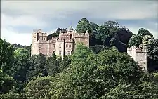
| Motte and bailey at Dunster Castle | Dunster | Castle | 11th century | SS9919643490 51°10′54″N 3°26′37″W | Dunster Castle is a former motte and bailey castle and now a country house on the top of a steep hill called the Tor. It has been fortified since the late Anglo-Saxon period. After the Norman conquest of England in the 11th century, William de Mohun constructed a timber castle on the site as part of the pacification of Somerset. A stone shell keep was built on the motte by the start of the 12th century, and the castle survived a siege during the early years of the Anarchy. At the end of the 14th century the de Mohuns sold the castle to the Luttrell family, who continued to occupy the property until the late 20th century. In 1976 Colonel Walter Luttrell gave Dunster Castle and most of its contents to the National Trust, which operates it as a tourist attraction. | 1020410 | [36] | |
| Mounsey Castle and an associated outwork 100 m to the north | Dulverton | Hillfort | Iron Age | SS 88555 29561 51°03′16″N 3°35′36″W | Earthworks of Mounsey Castle, an Iron Age irregular triangular earthwork. It is surrounded by the remains of coursed stone walling, with an entrance to the west. It overlooks the River Barle. | 1021357 | [37] [38][39] | |
| Oare Bridge | Oare | Bridge | Possibly 18th century | SS 80211 47452 51°12′18″N 3°41′24″W | Robber's Bridge is an old masonry arch bridge in the royal forest of Exmoor, carrying the minor road from Porlock Hill to Oare. It crosses Weir Water and is located down a steep, wooded lane beneath overhanging trees. | 1006196 | [40][41] [42] | |
| Old Barrow on Old Barrow Down | Withypool and Hawkridge | Bowl barrow | Neolithic to Bronze Age | SS 84085 32447 51°04′47″N 3°39′22″W | A bowl barrow which is 20.9 metres (69 ft) in diameter and 1.5 metres (4 ft 11 in) high. | 1021356 | Upload Photo | [43] |
| Oldberry Castle | Dulverton | Hillfort | Iron Age | SS 90942 28226 51°02′35″N 3°33′25″W | Oldberry Castle (sometimes called Oldbury Castle) is an Iron Age hill fort. The site overlooks the town and the ancient crossing point of the River Barle. It is an irregular oval shape measuring 220 metres (720 ft) by 300 feet (91 m). It is defended by a bank measuring 3.0 metres (10 ft) wide and 6 feet (1.8 m) high, and a 5.5 metres (18 ft) wide ditch. | 1006168 | [44][45] [46] | |
| Packhorse bridge 60 m north east of Royal Oak Farm | Winsford | Bridge | Middle Ages | SS 90551 34885 51°06′10″N 3°33′53″W | A stone packhorse bridge over Winn Brook. | 1021124 | .jpg.webp) Packhorse bridge 60 m north east of Royal Oak Farm | [47] |
| Packhorse bridge 75 m south east of The Old Vicarage | Winsford | Packhorse bridge | Middle Ages | SS 90570 35160 51°06′19″N 3°33′52″W | A medieval stone packhorse bridge, with two arches, over the River Exe. | 1021123 | 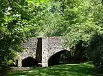 Packhorse bridge 75 m south east of The Old Vicarage | [48] |
| Porlock Allotment stone alignment and cairn, 450 m west of Porlock stone circle | Porlock | Standing stones and a cairn | Bronze Age | SS 84055 44701 51°11′23″N 3°39′38″W | A collection of standing stones and a cairn. | 1014268 | Upload Photo | [49] |
| Porlock Allotment 1: a stone alignment 450 m SSE of Black Barrow | Porlock | Standing stones | Neolithic to Bronze Age | SS 83359 43784 51°10′53″N 3°40′13″W | Three standing and five recumbent stones. | 1014270 | Upload Photo | [50] |
| Porlock Hill stone setting, 150 m north west of the cattle grid on the A39 at the top of Porlock Hill | Porlock | Standing stones | Neolithic to Bronze Age | SS 86450 46135 51°12′11″N 3°37′36″W | Three standing stones. | 1014267 | Upload Photo | [51] |
| Post-medieval pottery kiln 360 m NNE of the Castle | Dunster | Kiln | 18th century | SS 99226 43862 51°11′06″N 3°26′36″W | A stone pottery kiln. | 1020409 | Upload Photo | [52] |
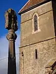
| Ralegh's Cross | Nettlecombe | Cross | 13th century | ST 03886 34415 51°06′04″N 3°22′26″W | The remains of a cross dating from around 1300. A stone base supports the remains of the shaft which is now 0.7 metres (2 ft 4 in) high. | 1020722 | Upload Photo | [53] |
| Raleigh's Cross iron mine, 310 m south east of Heather House | Huish Champflower | Earthworks | 1850s | ST 02526 34212 51°05′56″N 3°23′36″W | Earthworks and ruins from an iron mine opened in the 1850s. The buildings were demolished in 1907. | 1021351 | Upload Photo | [54] |
| Remains of 14th century chantry at Kilve | Kilve | Chantry Chapel | 1329 | ST 14644 44021 51°11′20″N 3°13′22″W | The ruins of a Chantry Chapel formed in 1329. The stonework is Blue Lias but is now ruined and covered in ivy. Little of the slate roof remains. The building was previously thatched. | 1002960 | [55] | |
| Remains of St Andrew's Chapel, 80 m north west of Chapel Cross | Luccombe | Earthworks | Middle Ages | SS 90577 44865 51°11′33″N 3°34′02″W | The remaining walls and footings of a medieval chapel | 1021120 | 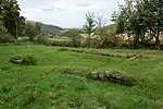 Remains of St Andrew's Chapel, 80 m north west of Chapel Cross | [56] |
| Rexy Barrow, Little Buscombe | Exmoor | Bowl barrow | Bronze Age | SS 77019 41950 51°09′49″N 3°45′37″W | A bowl barrow which is 18 metres (59 ft) in diameter. | 1006208 | Upload Photo | [57] |
| Ring cairn on West Hill | East Quantoxhead | Cairn | Bronze Age | ST 12327 41573 51°10′00″N 3°15′19″W | A stone cairn with a surrounding rim of 15.3 metres (50 ft) diameter. | 1014121 | Upload Photo | [58] |
| Road Castle | Winsford | Hill fort | Iron Age | SS 86289 37578 51°07′34″N 3°37′35″W | Road Castle is an Iron Age bank and ditch enclosure. The ditch is almost square in plan with rounded corners and covers an area of approximately 0.28 hectares (0.7 acres). | 1021360 | Upload Photo | [59][60] |
| Round barrow 200 ft (60 m) NW of Setta Barrow, Bray Common | Brayford | Round barrow | Bronze Age | SS 72523 38098 51°07′40″N 3°49′23″W | A 32-metre (105 ft) diameter mound which has been described as both a round barrow and bowl barrow. | 1003855 | Upload Photo | [61] |
| Round barrow 720 m NNW of Spire Cross | Winsford | Round barrow | Neolithic to Bronze Age | SS 88639 34246 51°05′48″N 3°35′30″W | A round barrow which is 15.5 metres (51 ft) in diameter. | 1021229 | Upload Photo | [62] |
| Round barrow 500 yd (460 m) WSW of Exe Head | Exmoor | Round barrow | Bronze Age | SS 74702 41411 51°09′30″N 3°47′35″W | A bowl barrow south of The Chains, which is 12.3 metres (40 ft) in diameter and 0.8 metres (2 ft 7 in) high. | 1006212 | Upload Photo | [63] |
| Round barrow 800 yd (730 m) SW of Dunkery Beacon | Cutcombe | Round barrow | Bronze Age | SS 88592 41151 51°09′31″N 3°35′40″W | A round barrow which is 12.3 metres (40 ft) in diameter. | 1006232 | Upload Photo | [64] |
| Round barrow cemetery at Battle Gore immediately west of North Road | Williton | Round barrow | Neolithic to Bronze Age | ST 07444 41392 51°09′51″N 3°19′30″W | Three round barrows and the Neolithic burial chamber. | 1019032 | Upload Photo | [65] |
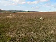
| Round barrow cemetery incorporating Wambarrows on Winsford Hill | Winsford | Round barrow | Bronze Age | SS 87616 34301 51°05′49″N 3°36′23″W | A round barrow cemetery at Wambarrows on Winsford Hill. There are at least five barrows ranging in diameter from 17.6 metres (58 ft) to 28.8 metres (94 ft). | 1021273 |  Round barrow cemetery incorporating Wambarrows on Winsford Hill | [66] |
| Round barrow on Great Tom's Hill | Exmoor | Round barrow | Bronze Age | SS 80496 43113 51°10′29″N 3°42′39″W | A 12.5-metre (41 ft) diameter stony mound covered in turf. | 1003032 | Upload Photo | [67] |
| Round barrow on Roosthitchen | Exmoor | Cairn | Prehistoric | SS 72192 40151 51°08′47″N 3°49′43″W | A turf covered mound with stones protruding from it. It was previously classified as a barrow. | 1006164 | Upload Photo | [68] |
| Round cairn 280 m south of Rex Stile Head | Wootton Courtenay | Cairn | Neolithic to Bronze Age | SS 90447 42282 51°10′09″N 3°34′06″W | A 9.4-metre (31 ft) diameter stoney mound. | 1020932 | Upload Photo | [69] |
| Round cairn 550 m north east of Joaney How Cairn | Wootton Courtenay | Cairn | Neolithic to Bronze Age | SS 91265 43105 51°10′36″N 3°33′24″W | A round cairn which is 15 metres (49 ft) in diameter. | 1020927 | Upload Photo | [70] |
| Round cairn 750 m south east of Joaney How Cairn | Wootton Courtenay | Cairn | Neolithic to Bronze Age | SS 91445 42371 51°10′13″N 3°33′15″W | An earth and stone mound, 8 metres (26 ft) in diameter and 1 metre (3 ft 3 in) high. | 1020928 | Upload Photo | [71] |
| Round cairn 1000 m ESE of Joaney How Cairn | Wootton Courtenay | Cairn | Neolithic to Bronze Age | SS 91732 42385 51°10′13″N 3°33′00″W | A cairn of 9 metres (30 ft) diameter. | 1020929 | Upload Photo | [72] |
| Round cairn cemetery, 570 m east of Selworthy Beacon | Minehead Without | Cairns | Late Neolithic to Bronze Age | SS 92175 48044 51°13′18″N 3°32′42″W | A collection of nine round cairns on a ridge of Selworthy Beacon. | 1020794 | Upload Photo | [73] |
| Round cairn cemetery on Dunkery Hill | Luccombe | Cairn | Neolithic to Bronze Age | SS 90883 42778 51°10′26″N 3°33′44″W | A collection of five round cairns each of which is between 21.5 metres (71 ft) and 24 metres (79 ft) in diameter. | 1020930 | Upload Photo | [74] |
| Round cairn known as Pixie's Mound | Stogursey | Cairn | Bronze Age | ST 20907 45575 51°12′14″N 3°08′01″W | A cairn which is 27 metres (89 ft) in diameter and 1.7 metres (5 ft 7 in) high. Excavations have found the remains of several bodies and flint tools. | 1006226 | Upload Photo | [75] |
| Ruined cairn on Higher Hare Knap | Holford | Cairn | Bronze Age | ST 14844 39516 51°08′55″N 3°13′08″W | A cairn or round barrow which is between 21 metres (69 ft) and 26.5 metres (87 ft) in diameter. | 1006144 | Upload Photo | [76] |
| Selworthy Beacon cairn | Minehead Without | Cairn | Neolithic to Bronze Age revised 16th century | SS 91868 47981 51°13′15″N 3°32′59″W | A cemetery cairn which was adapted in the 16th century for use as a fire beacon. The original earth and stone mound is topped with a 7 metres (23 ft) diameter stone heap. | 1020793 | [77] | |
| Setta Barrow and three round barrows to the south | Brayford Exmoor | Round barrow | Bronze Age | SS 72545 37699 51°07′28″N 3°49′21″W | Several bowl and round barrows ranging from 10 metres (33 ft) to 28 metres (92 ft) in diameter. | 1003856 | Upload Photo | [78][79][80] |
| Standing stones on Manor allotment | Oare | Standing stones | Prehistoric | SS 80180 43287 51°10′34″N 3°42′56″W | A line of three small stones. | 1006165 | Upload Photo | [81] |
| St Leonard's Well | Dunster | Holy well | Middle Ages | SS 98504 43867 51°11′04″N 3°27′13″W | A 16th century stone well house over a medieval holy well. It may have been the water supply for Dunster Priory. | 1021154 | _(geograph_1662996).jpg.webp) St Leonard's Well | [82] |
| Stogursey Castle | Stogursey | Motte-and-bailey castle | 11th or 12th century | ST 20326 42575 51°10′36″N 3°08′32″W | Stogursey Castle was built in the late 11th or early 12th century. The castle was a motte-and-bailey design with a 60 metre wide, two metre tall motte and two bailey enclosures, surrounded by a water-filled moat. The castle was controlled by King John of England during the First Barons' War, and was ordered to be destroyed in 1215, but survived; John's lieutenant Falkes de Breauté took control of the castle, and after his death a second order to destroy the property was given in 1228, again apparently ignored. The castle was extended in stone in 1300 by the Fitzpayne family, but was destroyed in the 1450s by the Yorkist faction during the War of the Roses. | 1019035 | [83][84] | |
| Stone circle, Porlock Common | Porlock | Stone circle | Neolithic to Bronze Age | SS 84520 44656 51°11′22″N 3°39′14″W | A stone circle which originally had 21 stones. 14 stones remain half of which are upright and the other half recumbent. The tallest of the standing stones is 0.8 metres (2 ft 7 in) high. | 1006189 | [85][86] | |
| Stone circle on Withypool Hill 670 m ESE of Portford Bridge | Withypool and Hawkridge | Stone circle | Neolithic to Bronze Age | SS 83827 34313 51°05′47″N 3°39′37″W | A stone circle which has 25 standing stones, some which were previously part of the circle are no longer present. The circle has a diameter of 36 metres (118 ft). | 1021261 | [87] | |
| Stringston churchyard cross | Stringston | Cross | Late 14th century | ST 17647 42388 51°10′29″N 3°10′46″W | A cross dating from the 14th century, which is on the Heritage at Risk Register. It has two steps and an octagonal shaft supporting a canopied head. | 1006171 | [88][89][90] | |
| Swap Hill standing stone 200 m south east of the Long Combe sheep pen | Exmoor | Standing stone | Neolithic to Bronze Age | SS 80513 42669 51°10′15″N 3°42′38″W | A 23-centimetre (9.1 in) high standing stone and a split fragment from the stone. | 1014272 | Upload Photo | [91] |
| Swap Hill stone setting, 275 m south east of the Long Combe sheep pen | Exmoor | Standing stones | Neolithic to Bronze Age | SS805426 51°10′12″N 3°42′35″W | Six standing stones the tallest of which are 90 centimetres (35 in) high. | 1014282 | Upload Photo | [92] |
| Sweetworthy deserted medieval settlement | Luccombe | Earthworks | Middle Ages | SS 88783 42383 51°10′11″N 3°35′32″W | Earthworks of several buildings cut into the terraces on the side of the hill. It has been added to the Heritage at Risk Register because of the vulnerability to plant growth. | 1008469 | Upload Photo | [93][94][95] |
| Sweetworthy Iron Age defended settlement | Luccombe | Hillfort | Iron Age | SS 89050 42534 51°10′17″N 3°35′25″W | A defended settlement on the north-facing slope of Dunkery Hill. It has a single rampart and external ditch, enclosing 0.25 hectares (0.62 acres). The rampart is still visible and the ditch on the east side is used as a trackway. | 1008470 | Upload Photo | [96][97][98] |
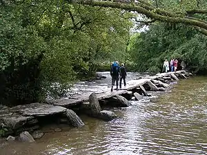
| Tarr Steps | Dulverton | Clapper bridge | Middle Ages | SS8677032116 51°04′38″N 3°37′04″W | The Tarr Steps are a clapper bridge across the River Barle in the Exmoor National Park. A typical clapper bridge construction, the bridge possibly dates to around 1000 BC. The stone slabs weigh up to 1-2 tons apiece. The bridge is 55 metres (180 ft) long and has 17 spans. | 1021325 | [99][100][101] | |
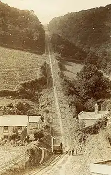
| The Incline, lying between Brendon Hill and Comberow, and the remains of Combe Row Station | Old Cleeve | Inclined plane | 1861 | ST 02648 34928 51°06′19″N 3°23′31″W | A rope-worked inclined plane 997 metres (3,272 ft) long to bring the ore down a 230 metres (770 ft) vertical interval on a 1 in 4 gradient on the West Somerset Mineral Railway. | 1021350 | [102][103][104] | |
| The Mound, Stoke Ridge, Stoke Pero | Luccombe | Round barrow | Bronze Age | SS 88098 43108 51°10′34″N 3°36′08″W | A possible round barrow which is 7 metres (23 ft) long and 6 metres (20 ft) wide. | 1006190 | .jpg.webp) The Mound, Stoke Ridge, Stoke Pero | [105] |
| The Whit Stones: two standing stones 230 m west of Whitstone Post | Porlock | Standing stones | Neolithic to Bronze Age | SS 85330 46250 51°12′14″N 3°38′34″W | Two standing stones 7 metres (23 ft) apart. Each is 85 centimetres (33 in) to 90 centimetres (35 in) high. | 1014269 | 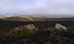 The Whit Stones: two standing stones 230 m west of Whitstone Post | [106] |
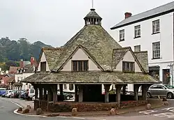
| The Yarn Market | Dunster | Market cross | 1609 | SS9915243812 51°11′05″N 3°26′40″W | The octagonal Yarn Market has a central stone pier which supports a heavy timber framework for the structure. The slate roof has a central wooden lantern topped by a weather vane. The roof is interrupted by a series of dormer windows. Around the periphery is a low stone wall and vertical timber supports. One of the roof beams has a hole in it, a result of cannon fire in the Civil War, when Dunster Castle was a besieged Royalist stronghold. Following the damage, it was restored in 1647 to its present condition. | 1015706 | [107][108] [109][110] [111] | |
| Three bowl barrows on Black Hill, 590 m north west of Crowcombe Park Gate | Holford | Bowl barrow | Bronze Age | ST 14738 38364 51°08′18″N 3°13′12″W | Three bowl barrows which are between 5 metres (16 ft) and 13 metres (43 ft) in diameter. | 1017219 | Upload Photo | [112] |
| Three round barrows on Withycombe Common, 360 m north of Fire Tower | Withycombe | Round barrow | Neolithic to Bronze Age | SS 98668 39592 51°08′47″N 3°27′00″W | Three round barrows two of which are approximately 12 metres (39 ft) in diameter. The largest, most southerly is the largest at approximately 28 metres (92 ft) in diameter and has an Ordnance Survey trig point on it. | 1021119 | .jpg.webp) Three round barrows on Withycombe Common, 360 m north of Fire Tower | [113] |
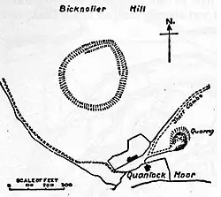
| Trendle Ring hillfort and associated outwork | Bicknoller | Hill fort | Bronze Age to Iron Age | ST 11825 39359 51°08′48″N 3°15′43″W | Trendle Ring is a late prehistoric earthwork. The site, which covers 0.8 hectares (2.0 acres), is surrounded by a single rampart with a ditch and has a simple opening on the east, uphill side. The hillside is steep and there are two areas which may have been more level platforms. It is situated on the slope of a hill which rises 130 metres (430 ft) above the ring. | 1008249 | [114][115] | |
| Tripp round barrow NW of Tripp Farm | Clatworthy | Round barrow | Bronze Age | ST 03771 33408 51°05′31″N 3°22′32″W | A round barrow approximately 20 metres (66 ft) in diameter. | 1006125 | .jpg.webp) Tripp round barrow NW of Tripp Farm | [116] |
| Trout Hill 1: a stone setting on the north east end of Trout Hill 550 m south west of the foot bridge over Badgworthy Water | Exmoor | Standing stone | Neolithic to Bronze Age | SS 79399 43226 51°10′32″N 3°43′36″W | Five standing stones, one of which is broken, in two intersecting rows. The largest is 70 centimetres (28 in) high. | 1014264 | Upload Photo | [117] |
| Trout Hill 2: a stone setting on the north east end of Trout Hill 610 m south of the foot bridge over Badgworthy Water | Exmoor | Standing stone | Neolithic to Bronze Age | SS 79554 43124 51°10′29″N 3°43′27″W | Three standing and one recumbent stones. One other stone was demolished by an unexploded shell in the 1970s leaving a crater on the site. | 1014265 | Upload Photo | [118] |
| Trout Hill 3: a stone setting on the north east end of Trout Hill 850 m SSW of the foot bridge over Badgeworthy Water | Exmoor | Standing stone | Neolithic to Bronze Age | SS 79412 42885 51°10′21″N 3°43′35″W | Two standing and two recumbent stones. The tallest standing stone is 30 centimetres (12 in) high. | 1014266 | Upload Photo | [119] |
| 'Two Barrows', group of barrows (Hangley Cleave) | North Molton | Bowl barrows | Bronze Age | SS 74635 36212 51°06′41″N 3°47′32″W | A group of four bowl barrows which straddles the border between Somerset and Devon. | 1006210 | .jpg.webp) 'Two Barrows', group of barrows (Hangley Cleave) | [120] |
| Two bowl barrows on Beacon Hill | West Quantoxhead | Bowl barrow | Neolithic to Bronze Age | ST 12444 40997 51°09′41″N 3°15′13″W | Two bowl barrows each approximately 24 metres (79 ft) in diameter. An Ordnance Survey trig point is on the more southerly of the two barrows. | 1014122 | Two bowl barrows on Beacon Hill | [121] |
| Two cairns on Great Hill, 470 m south and 750 m south west of Quantock Farm | Crowcombe | Cairn | Bronze Age | ST 15657 36251 51°07′09″N 3°12′23″W | Two cairns approximately 300 metres (980 ft) apart. The mound on the summit of the hill is 21 metres (69 ft) in diameter and the other 28 metres (92 ft). | 1020364 | .jpg.webp) Two cairns on Great Hill, 470 m south and 750 m south west of Quantock Farm | [122] |
| Two cairns and two bowl barrows on Weacombe Hill, 440 m south of Bicknoller Post | Bicknoller | Cairns and bowl barrows | Bronze Age | ST 12862 39893 51°09′06″N 3°14′50″W | Two cairns and two bowl barrows dating from the Bronze Age three of them have been disturbed or partially excavated in the past. | 1014126 | Upload Photo | [123] |
| Two round barrows on Culbone Hill | Oare | Round barrows or cairns | Bronze Age | SS 82400 47603 51°12′56″N 3°41′06″W | Grass covered stony mounds previously classified as cairns and now as round barrows. Each approximately 10 metres (33 ft) in diameter. | 1006207 | Upload Photo | [124][125] |
| Two round barrows on Heydon Hill | Huish Champflower | Round barrow | Bronze Age | ST 03624 27978 51°02′35″N 3°22′34″W | Two barrows, partially excavated in 1896. | 1006143 | Upload Photo | [126] |
| Two round cairns on Dunkery Hill, 390 m and 420 m south east of Rex Stile Head | Wootton Courtenay | Cairn | Neolithic to Bronze Age | SS 90779 42302 51°10′10″N 3°33′49″W | Two mounds, one of 11 metres (36 ft) in diameter and the other 9 metres (30 ft). | 1020926 | Upload Photo | [127] |
| Two standing stones and a mound 200 m WSW of Black Barrow, Hoscombe | Exmoor | Standing stones | Neolithic to Bronze Age | SS 83011 44163 51°11′05″N 3°40′31″W | Two stones 4.7 metres (15 ft) apart. One is 25 centimetres (9.8 in) high and the other 10 centimetres (3.9 in) high. The 5 metres (16 ft) wide mound is 11.7 metres (38 ft) from the nearest stone. | 1014271 | Upload Photo | [128] |
| Village cross 75 m north of St Andrew's Well | Stogursey | Cross | 13th or 14th century | ST 20241 42891 51°10′47″N 3°08′33″W | The remains of a Hamstone village cross on the High Street is from the Middle Ages. Approximately 1 metre (3 ft 3 in) of the original shaft is still in the socket stone. | 1019034 | Upload Photo | [129][130] |
| Wayside cross 100 m south east of Doniford Farm | Williton | Cross | Middle Ages | ST 08838 42897 51°10′41″N 3°18′20″W | The socket stone and part of the shaft of a medieval cross on the main street in Doniford. | 1019292 | 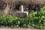 Wayside cross 100 m south east of Doniford Farm | [131] |
| Wayside cross at junction of High Street and Bank Street | Williton | Cross | Middle Ages | ST 07737 40924 51°09′36″N 3°19′15″W | The remains of a medieval cross which still has its octagonal base and 0.75 metres (2 ft 6 in) of the shaft. | 1017292 | 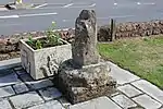 Wayside cross at junction of High Street and Bank Street | [132] |
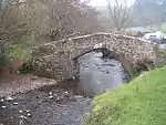
| West Luccombe packhorse bridge | Luccombe | Packhorse bridge | Middle Ages | SS 89886 46119 51°12′13″N 3°34′39″W | A single arch packhorse bridge built of red sandstone. | 1006227 | [133][134] | |
| Wilmersham Common West: a stone row 120 m south east of the confluence of Chetsford and Embercombe waters | Luccombe | Stone row | Neolithic to Bronze Age | SS 85544 42131 51°10′01″N 3°38′18″W | Two standing and one recumbent stones. | 1014258 | Upload Photo | [135] |
| Wilmersham Common stone row 320 m south east of the confluence of Embercombe and Chetsford waters | Luccombe | Stone row | Neolithic to Bronze Age | SS 85670 41976 51°09′56″N 3°38′11″W | A 68-metre (223 ft) long row of 50 standing stones. The tallest of which is 60 centimetres (24 in) high. | 1014257 | Upload Photo | [136] |
| Wiveliscombe Barrow | Brompton Regis | Bowl barrow | Neolithic to Bronze Age | ST 00553 34857 51°06′16″N 3°25′18″W | Wiveliscombe Barrow. which was previously known as Eastern Barrow is 20.5 metres (67 ft) in diameter. | 1020773 | .jpg.webp) Wiveliscombe Barrow | [137] |
| Wood Barrow round barrow | Challacombe | Bowl barrow | Neolithic to Bronze Age | SS 71631 42506 51°10′03″N 3°50′15″W | A bowl barrow approximately 28 metres (92 ft) in diameter. | 1003838 1006209 | 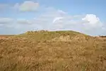 Wood Barrow round barrow | [138] |
| World War II pillbox 100 m west of Ralegh's Cross Hotel | Clatworthy | Pillbox | 1940 | ST 03837 34397 51°06′03″N 3°22′29″W | A Type 24 pillbox made of reinforced concrete. | 1020723 | Upload Photo | [139] |
| World War II pillbox at Vale House, 120 m north east of Glasses Farm | Old Cleeve | Pillbox | 1940 | ST 02792 38004 51°07′59″N 3°23′27″W | A concrete pillbox which is 2.6 metres (8 ft 6 in) high. | 1020726 | .jpg.webp) World War II pillbox at Vale House, 120 m north east of Glasses Farm | [140] |
.jpg.webp)

See also
- Scheduled monuments in West Somerset – overview of scheduled monuments
- Scheduled monuments in West Somerset (A–G) – list of scheduled monuments
- Scheduled monuments in Taunton Deane – overview and list of scheduled monuments
Notes
- The date given is the date used by Historic England as significant for the initial building or that of an important part in the structure's description.
- Sometimes known as OSGB36, the grid reference is based on the British national grid reference system used by the Ordnance Survey.
- The "List Entry Number" is a unique number assigned to each listed building and scheduled monument by Historic England.
References
- "Halscombe stone setting 790 m SSW of Simonsbath Bridge". National Heritage List for England. Historic England. Archived from the original on 13 January 2015. Retrieved 27 December 2014.
- Historic England. "Monument No. 36851". Research records (formerly PastScape). Retrieved 23 March 2011.
- "Grabbist Hillfort". Exmoor Historic Environment Record. English Heritage. Retrieved 23 March 2011.
- "Holy well at St Pancras Chapel". National Heritage List for England. Historic England. Archived from the original on 13 January 2015. Retrieved 27 December 2014.
- Historic England. "Horner Bridge (35858)". Research records (formerly PastScape). Retrieved 27 December 2014.
- "Huish Champflower Barrow". National Heritage List for England. Historic England. Retrieved 28 February 2015.
- Historic England. "Culbone Stone (35920)". Research records (formerly PastScape). Retrieved 23 November 2014.
- "Incised stone W of Stent Hill". Somerset Historic Environment Record. Somerset County Council. Retrieved 23 November 2014.
- "MSO7891 - Culbone Stone, Culbone Hill". Exmoor National Park Historic Environment Record. Exmoor National Park. Retrieved 23 November 2014.
- "Culbone Stone". Megalithic Portal. Retrieved 24 October 2007.
- "Culbone Stone". The Modern Antiquarian. Retrieved 24 October 2007.
- "Iron Age defended settlement above Sweetworthy (eastern of two)". National Heritage List for England. Historic England. Archived from the original on 13 January 2015. Retrieved 29 December 2014.
- "Iron Age defended settlement above Sweetworthy (western of two)". National Heritage List for England. Historic England. Archived from the original on 13 January 2015. Retrieved 29 December 2014.
- "Iron Age defended settlement, Furzebury Brake". National Heritage List for England. Historic England. Archived from the original on 29 January 2015. Retrieved 29 December 2014.
- "Ironstone mine ventilation flue in Chargot Wood, 1150 m south west of Langham Farm". National Heritage List for England. Historic England. Archived from the original on 29 January 2015. Retrieved 29 December 2014.
- "Katherine's Well". National Heritage List for England. Historic England. Archived from the original on 29 January 2015. Retrieved 29 December 2014.
- "Kit Barrows Cairns". National Heritage List for England. Historic England. Archived from the original on 29 January 2015. Retrieved 29 December 2014.
- "Kittuck stone setting and cairn, 200 m south west of Three Combes Foot". National Heritage List for England. Historic England. Archived from the original on 29 January 2015. Retrieved 29 December 2014.
- "Lanacombe 1: a stone setting and two cairns on the east side of Lanacombe". National Heritage List for England. Historic England. Archived from the original on 13 January 2015. Retrieved 29 December 2014.
- "Lanacombe 2: a stone setting and cairn on the east side of Lanacombe". National Heritage List for England. Historic England. Archived from the original on 13 January 2015. Retrieved 29 December 2014.
- "Lanacombe 3: a stone setting and cairn on the east side of Lanacombe". National Heritage List for England. Historic England. Archived from the original on 13 January 2015. Retrieved 29 December 2014.
- "Lanacombe 4: a stone setting on the ENE side of Lanacombe". National Heritage List for England. Historic England. Archived from the original on 13 January 2015. Retrieved 29 December 2014.
- "Lanacombe 5: a stone alignment on the south east side of Lanacombe". National Heritage List for England. Historic England. Archived from the original on 13 January 2015. Retrieved 29 December 2014.
- "Landacre Bridge". National heritage list for England. Historic England. Archived from the original on 10 September 2014. Retrieved 17 July 2013.
- Otter, R.A. (1994). Civil Engineering Heritage: Southern England. Thomas Telford Ltd. pp. 91–92. ISBN 978-0727719713.
- "MSO8670 - Landacre Bridge". Exmoor National Park Historic Environment Record. Exmoor National Park. Retrieved 11 October 2014.
- "Later prehistoric defended enclosure, Long Wood". National Heritage List for England. Historic England. Archived from the original on 2 May 2014. Retrieved 1 December 2014.
- "MSO9087 - Long Wood Enclosure". Exmoor National Park Historic Environment Record. Exmoor National Park. Retrieved 1 December 2014.
- Historic England. "Longwood (36926)". Research records (formerly PastScape). Retrieved 1 December 2014.
- "Leather Barrow". National Heritage List for England. Historic England. Archived from the original on 13 January 2015. Retrieved 29 December 2014.
- "Lock up 60 m south east of St Mary's Church". National Heritage List for England. Historic England. Archived from the original on 8 December 2014. Retrieved 23 November 2014.
- "Long Chains Combe North: a stone setting 120 m WNW of the sheepfold". National Heritage List for England. Historic England. Archived from the original on 13 January 2015. Retrieved 30 December 2014.
- "Long Chains Combe South: two standing stones 380 m south west of the sheepfold". National Heritage List for England. Historic England. Archived from the original on 13 January 2015. Retrieved 30 December 2014.
- Historic England. "Malmsmead Bridge (35099)". Research records (formerly PastScape). Retrieved 30 December 2014.
- Historic England. "Malmsmead Bridge (1289346)". National Heritage List for England. Retrieved 30 December 2014.
- "Dunster Castle and gatehouse". Historic England. Archived from the original on 29 November 2014. Retrieved 10 August 2013.
- Historic England. "Mounsey Castle (35638)". Research records (formerly PastScape). Retrieved 24 March 2011.
- "Mounsey Castle". Exmoor National Park Historic Environment Record. English Heritage. Retrieved 16 January 2011.
- "Mounsey Castle and associated outwork 100 m to the north". Historic Environment Record. Somerset County Council. Retrieved 28 February 2011.
- Montgomery, Elizabeth. "Robbers Bridge". Everything Exmoor. Retrieved 2 October 2013.
- Ross, David. "Oare, Somerset Lorna Doone Country". Historic Somerset Guide. Retrieved 2 October 2013.
- Historic England. "Oare Bridge (35923)". Research records (formerly PastScape). Retrieved 30 December 2014.
- "Old Barrow on Old Barrow Down". National Heritage List for England. Historic England. Archived from the original on 13 January 2015. Retrieved 30 December 2014.
- "Oldbury (or Oldberry) Castle, NW of Dulverton". Exmoor National Park Historic Environment Record. English Heritage. Retrieved 16 January 2011.
- Gathercole, Clare. "Dulverton" (PDF). English Heritage Extensive Urban Survey. Somerset County Council. Archived from the original (PDF) on 4 March 2016. Retrieved 17 August 2016.
- "Oldberry Castle, Oldbury Castle". Fortified England. Archived from the original on 11 July 2011. Retrieved 15 January 2011.
- "Packhorse bridge 60 m north east of Royal Oak Farm". National Heritage List for England. Historic England. Archived from the original on 13 January 2015. Retrieved 31 December 2014.
- "Packhorse bridge 75 m south east of The Old Vicarage". National Heritage List for England. Historic England. Retrieved 28 February 2015.
- "Porlock Allotment stone alignment and cairn, 450 m west of Porlock stone circle". National Heritage List for England. Historic England. Archived from the original on 13 January 2015. Retrieved 31 December 2014.
- "Porlock Allotment 1: a stone alignment 450 m SSE of Black Barrow". National Heritage List for England. Historic England. Archived from the original on 13 January 2015. Retrieved 31 December 2014.
- "Porlock Hill stone setting, 150 m north west of the cattle grid on the A39 at the top of Porlock Hill". National Heritage List for England. Historic England. Archived from the original on 13 January 2015. Retrieved 31 December 2014.
- "Post-medieval pottery kiln 360 m NNE of the Castle". National Heritage List for England. Historic England. Archived from the original on 13 January 2015. Retrieved 31 December 2014.
- "Ralegh's Cross". National Heritage List for England. Historic England. Archived from the original on 13 January 2015. Retrieved 31 December 2014.
- "Raleigh's Cross iron mine, 310 m south east of Heather House". National Heritage List for England. Historic England. Archived from the original on 13 January 2015. Retrieved 31 December 2014.
- "Kilve chantry, Kilve". Somerset Historic Environment Record. Somerset County Council. Retrieved 7 January 2010.
- "Remains of St Andrew's Chapel, 80 m north west of Chapel Cross". National Heritage List for England. Historic England. Retrieved 28 February 2015.
- Historic England. "Rexy Barrow (35234)". Research records (formerly PastScape). Retrieved 6 January 2015.
- "Ring cairn on West Hill". National Heritage List for England. Historic England. Archived from the original on 13 January 2015. Retrieved 6 January 2015.
- Historic England. "Road Castle (35715)". Research records (formerly PastScape). Retrieved 12 May 2011.
- "Road Castle". National Heritage List for England. Historic England. Archived from the original on 20 June 2014. Retrieved 28 February 2015.
- Historic England. "Monument No. 35030". Research records (formerly PastScape). Retrieved 16 January 2015.
- "Round barrow 720 m NNW of Spire Cross". National Heritage List for England. Historic England. Archived from the original on 13 January 2015. Retrieved 6 January 2015.
- Historic England. "Monument No. 35331". Research records (formerly PastScape). Retrieved 11 January 2015.
- Historic England. "Monument No. 35331". Research records (formerly PastScape). Retrieved 13 January 2015.
- "Round barrow cemetery at Battle Gore immediately west of North Road". National Heritage List for England. Historic England. Retrieved 28 February 2015.
- "Round barrow cemetery incorporating Wambarrows on Winsford Hill". National Heritage List for England. Historic England. Archived from the original on 13 January 2015. Retrieved 11 January 2015.
- Historic England. "Monument No. 36255". Research records (formerly PastScape). Retrieved 13 January 2015.
- Historic England. "Monument No. 35336". Research records (formerly PastScape). Retrieved 13 January 2015.
- "Round cairn 280 m south of Rex Stile Head". National Heritage List for England. Historic England. Archived from the original on 29 January 2015. Retrieved 16 January 2015.
- "Round cairn 550 m north east of Joaney How Cairn". National Heritage List for England. Historic England. Retrieved 28 February 2015.
- "Round cairn 750 m south east of Joaney How Cairn". National Heritage List for England. Historic England. Retrieved 16 January 2015.
- "Round cairn 1000 m ESE of Joaney How Cairn". National Heritage List for England. Historic England. Archived from the original on 29 January 2015. Retrieved 16 January 2015.
- "Round cairn cemetery, 570 m east of Selworthy Beacon". National Heritage List for England. Historic England. Retrieved 28 February 2015.
- "Round cairn cemetery on Dunkery Hill". National Heritage List for England. Historic England. Archived from the original on 29 January 2015. Retrieved 16 January 2015.
- "Round cairn known as Pixie's Mound". National Heritage List for England. Historic England. Archived from the original on 29 January 2015. Retrieved 16 January 2015.
- Historic England. "Monument No. 189581". Research records (formerly PastScape). Retrieved 16 January 2015.
- "Selworthy Beacon cairn". National Heritage List for England. Historic England. Archived from the original on 22 January 2015. Retrieved 19 January 2015.
- Historic England. "Setta Barrow (35008)". Research records (formerly PastScape). Retrieved 19 January 2015.
- Historic England. "Monument No. 35033". Research records (formerly PastScape). Retrieved 19 January 2015.
- Historic England. "Monument No. 35052". Research records (formerly PastScape). Retrieved 19 January 2015.
- Historic England. "Stone setting (1066024)". Research records (formerly PastScape). Retrieved 19 January 2015.
- "St Leonard's Well". National Heritage List for England. Historic England. Archived from the original on 29 January 2015. Retrieved 19 January 2015.
- Stogursey Castle, the Gatehouse website, accessed 22 April 2011.
- Historic England. "Stogursey Castle (1057403)". National Heritage List for England. Retrieved 9 May 2011.
- Historic England. "Porlock Stone Circle (36228)". Research records (formerly PastScape). Retrieved 19 January 2015.
- "MSO7898 - Porlock Stone Circle". Exmoor Historic Environment Record. Exmoor National Park. Retrieved 19 January 2015.
- "Stone circle on Withypool Hill 670 m ESE of Portford Bridge". National Heritage List for England. Historic England. Archived from the original on 22 January 2015. Retrieved 19 January 2015.
- "Stringston churchyard cross, Stringston - West Somerset". Heritage at Risk. Historic England. Retrieved 28 October 2015.
- Historic England. "Churchyard Cross (1308144)". National Heritage List for England. Retrieved 6 January 2008.
- Historic England. "Monument No. 189779". Research records (formerly PastScape). Retrieved 20 January 2015.
- "Swap Hill standing stone 200 m south east of the Long Combe sheep pen". National Heritage List for England. Historic England. Archived from the original on 29 January 2015. Retrieved 20 January 2015.
- "Swap Hill stone setting, 275 m south east of the Long Combe sheep pen". National Heritage List for England. Historic England. Archived from the original on 29 January 2015. Retrieved 20 January 2015.
- "Sweetworthy deserted medieval settlement". National Heritage List for England. Historic England. Archived from the original on 29 October 2013. Retrieved 20 October 2013.
- "Sweetworthy Deserted Medieval Settlement". Exmoor National Park Historic Environment Record. English Heritage. Retrieved 16 January 2011.
- "Sweetworthy deserted Medieval settlement, Luccombe, West Somerset - Exmoor (NP)". Heritage at Risk. Historic England. Retrieved 28 October 2015.
- Historic England. "Sweetworthy (35980)". Research records (formerly PastScape). Retrieved 16 March 2011.
- "Sweetworthy". Exmoor National Park Historic Environment Record. English Heritage. Retrieved 16 January 2011.
- "Sweetworthy Enclosure". Exmoor National Park Historic Environment Record. English Heritage. Retrieved 16 January 2011.
- "Tarr Steps". Historic England. Archived from the original on 29 November 2014. Retrieved 10 August 2013.
- Historic England. "Tarr Steps (1247822)". National Heritage List for England. Retrieved 9 May 2007.
- Leete-Hodge, Lornie (1985). Curiosities of Somerset. Bodmin: Bossiney Books. pp. 63–64. ISBN 0-906456-98-3.
- "West Somerset Mineral Railway Extension". North Devon Journal. British Newspaper Archive. 29 September 1864. Retrieved 19 July 2014.
- R.W. Dunning (editor), A.P. Baggs, R.J.E. Bush, M.C. Siraut (1985). "Parishes: Old Cleeve". A History of the County of Somerset: Volume 5. Institute of Historical Research. Retrieved 22 July 2014.
{{cite web}}:|author=has generic name (help)CS1 maint: multiple names: authors list (link) - "The Incline, lying between Brendon Hill and Comberow, and the remains of Combe Row Station". National Heritage List for England. Historic England. Archived from the original on 29 January 2015. Retrieved 1 March 2015.
- Historic England. "Monument No. 35951". Research records (formerly PastScape). Retrieved 20 January 2015.
- "The Whit Stones: two standing stones 230 m west of Whitstone Post". National Heritage List for England. Historic England. Archived from the original on 22 January 2015. Retrieved 20 January 2015.
- "Yarn Market". Historic England. Archived from the original on 29 November 2014. Retrieved 10 August 2013.
- Heritage Unlocked. Historic England. 2004. p. 66. ISBN 1850748756.
- Brown, Patrick (1981). Buildings of Britain 1550-1750: South West England. Moorland. pp. 100–101. ISBN 0861900308.
- "Brief History of Dunster". Dunster Tithe Barn. Retrieved 26 May 2009.
- "The Yarn Market". Historic England. Archived from the original on 22 January 2015. Retrieved 10 August 2013.
- "Three bowl barrows on Black Hill, 590 m north west of Crowcombe Park Gate". National Heritage List for England. Historic England. Retrieved 28 February 2015.
- "Three round barrows on Withycombe Common, 360 m north of Fire Tower". National Heritage List for England. Historic England. Archived from the original on 23 January 2015. Retrieved 22 January 2015.
- "Trendle Ring hillfort and associated outwork". National Heritage List for England. Historic England. Archived from the original on 2 May 2014. Retrieved 28 February 2015.
- "Trendle Ring hillfort, Bicknoller Hill, Bicknoller". Somerset Historic Environment Record. Somerset County Council. Retrieved 1 February 2011.
- Historic England. "Tripp Barrow (188448)". Research records (formerly PastScape). Retrieved 22 January 2015.
- "Trout Hill 1: a stone setting on the north east end of Trout Hill 550 m south west of the foot bridge over Badgworthy Water". National Heritage List for England. Historic England. Archived from the original on 23 January 2015. Retrieved 22 January 2015.
- "Trout Hill 2: a stone setting on the north east end of Trout Hill 610 m south of the foot bridge over Badgworthy Water". National Heritage List for England. Historic England. Archived from the original on 23 January 2015. Retrieved 22 January 2015.
- "Trout Hill 3: a stone setting on the north east end of Trout Hill 850 m SSW of the foot bridge over Badgeworthy Water". National Heritage List for England. Historic England. Archived from the original on 23 January 2015. Retrieved 22 January 2015.
- Historic England. "Two Barrows (35011)". Research records (formerly PastScape). Retrieved 22 January 2015.
- "Two bowl barrows on Beacon Hill". National Heritage List for England. Historic England. Archived from the original on 23 January 2015. Retrieved 22 January 2015.
- "Two cairns on Great Hill, 470 m south and 750 m south west of Quantock Farm". National Heritage List for England. Historic England. Archived from the original on 23 January 2015. Retrieved 22 January 2015.
- "Two cairns and two bowl barrows on Weacombe Hill, 440 m south of Bicknoller Post". National Heritage List for England. Historic England. Archived from the original on 29 January 2015. Retrieved 22 January 2015.
- Historic England. "Monument No. 35896". Research records (formerly PastScape). Retrieved 23 January 2015.
- Historic England. "Monument No. 35893". Research records (formerly PastScape). Retrieved 23 January 2015.
- Historic England. "Monument No. 188228". Research records (formerly PastScape). Retrieved 23 January 2015.
- "Two round cairns on Dunkery Hill, 390 m and 420 m south east of Rex Stile Head". National Heritage List for England. Historic England. Archived from the original on 23 January 2015. Retrieved 23 January 2015.
- "Two standing stones and a mound 200 m WSW of Black Barrow, Hoscombe". National Heritage List for England. Historic England. Archived from the original on 23 January 2015. Retrieved 23 January 2015.
- "Village cross 75 m north of St Andrew's Well". National Heritage List for England. Historic England. Archived from the original on 23 January 2015. Retrieved 23 January 2015.
- "Remains of Village cross". National Heritage List for England. Historic England. Archived from the original on 23 January 2015. Retrieved 23 January 2015.
- "Wayside cross 100 m south east of Doniford Farm". National Heritage List for England. Historic England. Archived from the original on 23 January 2015. Retrieved 23 January 2015.
- "Wayside cross at junction of High Street and Bank Street". National Heritage List for England. Historic England. Archived from the original on 23 January 2015. Retrieved 23 January 2015.
- Historic England. "Packhorse Bridge at NGR SS 8987 4608 (1174852)". National Heritage List for England. Retrieved 23 January 2015.
- Historic England. "Monument No. 35855". Research records (formerly PastScape). Retrieved 23 January 2015.
- "Wilmersham Common West: a stone row 120 m south east of the confluence of Chetsford and Embercombe waters". National heritage List for England. Historic England. Archived from the original on 23 January 2015. Retrieved 23 January 2015.
- "Wilmersham Common stone row 320 m south east of the confluence of Embercombe and Chetsford waters". National heritage List for England. Historic England. Archived from the original on 23 January 2015. Retrieved 23 January 2015.
- "Wiveliscombe Barrow". National heritage List for England. Historic England. Archived from the original on 23 January 2015. Retrieved 23 January 2015.
- Historic England. "Wood Barrow (35361)". Research records (formerly PastScape). Retrieved 23 January 2015.
- "World War II pillbox 100 m west of Ralegh's Cross Hotel". National Heritage List for England. Historic England. Archived from the original on 23 January 2015. Retrieved 23 January 2015.
- "World War II pillbox at Vale House, 120 m north east of Glasses Farm". National Heritage List for England. Historic England. Archived from the original on 23 January 2015. Retrieved 23 January 2015.
This article is issued from Wikipedia. The text is licensed under Creative Commons - Attribution - Sharealike. Additional terms may apply for the media files.