Senneçay
Senneçay (French pronunciation: [sɛnsɛ]) is a commune in the Cher department in the Centre-Val de Loire region of France.
Senneçay | |
|---|---|
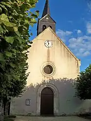 The church in Senneçay | |
.svg.png.webp) Coat of arms | |
Location of Senneçay | |
 Senneçay  Senneçay | |
| Coordinates: 46°57′07″N 2°26′16″E | |
| Country | France |
| Region | Centre-Val de Loire |
| Department | Cher |
| Arrondissement | Bourges |
| Canton | Trouy |
| Intercommunality | CC Le Dunois |
| Government | |
| • Mayor (2020–2026) | Irène Thibault[1] |
| Area 1 | 14.47 km2 (5.59 sq mi) |
| Population | 468 |
| • Density | 32/km2 (84/sq mi) |
| Time zone | UTC+01:00 (CET) |
| • Summer (DST) | UTC+02:00 (CEST) |
| INSEE/Postal code | 18248 /18340 |
| Elevation | 154–181 m (505–594 ft) (avg. 172 m or 564 ft) |
| 1 French Land Register data, which excludes lakes, ponds, glaciers > 1 km2 (0.386 sq mi or 247 acres) and river estuaries. | |
Geography
Senneçay is a farming village situated about 10 miles (16 km) south of Bourges, at the junction of the D46 and the D34 roads. The A71 autoroute forms the commune's western border.
Population
| Year | Pop. | ±% |
|---|---|---|
| 1962 | 305 | — |
| 1968 | 328 | +7.5% |
| 1975 | 288 | −12.2% |
| 1982 | 258 | −10.4% |
| 1990 | 347 | +34.5% |
| 1999 | 345 | −0.6% |
| 2008 | 435 | +26.1% |
Sights
- The church of St. Pierre, dating from the thirteenth century.
See also
References
- "Répertoire national des élus: les maires" (in French). data.gouv.fr, Plateforme ouverte des données publiques françaises. 13 September 2022.
- "Populations légales 2020". The National Institute of Statistics and Economic Studies. 29 December 2022.
Wikimedia Commons has media related to Senneçay.
This article is issued from Wikipedia. The text is licensed under Creative Commons - Attribution - Sharealike. Additional terms may apply for the media files.