Shire of Serpentine-Jarrahdale
The Shire of Serpentine-Jarrahdale is a local government area in the outer southeastern metropolitan area of Perth, the capital of Western Australia, and has an area of 905 square kilometres (349 sq mi) and a population of 32,173 as at the 2021 Census. Despite being named after two towns in the area neither Serpentine nor Jarrahdale function as either the Shire's largest settlement (Byford) or the seat of government (Mundijong).
| Shire of Serpentine-Jarrahdale Western Australia | |||||||||||||||
|---|---|---|---|---|---|---|---|---|---|---|---|---|---|---|---|
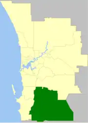 The Shire of Serpentine-Jarrahdale within the Perth Metropolitan Area | |||||||||||||||
| Population | 32,173 (LGA 2021)[1] | ||||||||||||||
| Established | 1894 | ||||||||||||||
| Area | 905 km2 (349.4 sq mi) | ||||||||||||||
| Shire President | Michelle Rich | ||||||||||||||
| Council seat | Mundijong | ||||||||||||||
| Region | Peel region | ||||||||||||||
| State electorate(s) | Darling Range | ||||||||||||||
| Federal division(s) | Canning | ||||||||||||||
| Website | Shire of Serpentine-Jarrahdale | ||||||||||||||
| |||||||||||||||
History
The Serpentine-Jarrahdale Road District was established on 8 August 1913 with the amalgamation of the Serpentine Road District (1894) and Jarrahdale Road District (1902).[2][3][4]
On 1 July 1961, it became a Shire following the passage of the Local Government Act 1960, which reformed all remaining road districts into shires. On 17 June 1977, it acquired Byford from Shire of Armadale–Kelmscott.[2]
Wards
The Shire was previously split into four wards, named Byford, Central, North West and South. Recently, the boundaries were realigned and on 29 July 2011, the gazetted[5] boundaries became:
- North (4 councillors)
- North West (2 councillors)
- Southern (3 councillors)
Elections to fill all positions in these new wards were called for 15 October 2011. The latest council elections were held on 16 October 2021 and confirmed Michelle Rich as Shire President and Dave Atwell as her deputy.[6]
Suburbs and towns
The suburbs, towns and localities of the Shire of Serpentine-Jarrahdale with population and size figures based on the most recent Australian census:[7][8]
| Suburb | Population | Area | Map |
|---|---|---|---|
| Byford | 18,878 (SAL 2021)[9] | 22 km2 (8.5 sq mi) | |
| Cardup | 1,163 (SAL 2021)[10] | 19.0 km2 (7.3 sq mi) | |
| Darling Downs | 1,591 (SAL 2021)[11] | 9.8 km2 (3.8 sq mi) | |
| Hopeland | 313 (SAL 2021)[12] | 51.4 km2 (19.8 sq mi) | |
| Jarrahdale | 1,205 (SAL 2021)[13] | 256.4 km2 (99.0 sq mi) | |
| Karrakup | 172 (SAL 2021)[14] | 78.6 km2 (30.3 sq mi) | |
| Keysbrook | 265 (SAL 2021)[15] | 180.6 km2 (69.7 sq mi) | |
| Mardella | 446 (SAL 2021)[16] | 64.4 km2 (24.9 sq mi) | |
| Mundijong | 1,246 (SAL 2021)[17] | 18.4 km2 (7.1 sq mi) | |
| Oakford | 2,803 (SAL 2021)[18] | 46.9 km2 (18.1 sq mi) | |
| Oldbury | 296 (SAL 2021)[19] | 41.1 km2 (15.9 sq mi) | |
| Serpentine | 2,863 (SAL 2021)[20] | 104.8 km2 (40.5 sq mi) | |
| Whitby | 1,005 (SAL 2021)[21] | 16.8 km2 (6.5 sq mi) |
Population
|
|
- 1911 populations were: Serpentine RD 328; Jarrahdale RD 1,126.
- The 1976 figure above, reported from the 1978 year book and 1981 census, is the figure after the addition of 1,634 residents living in Byford and nearby areas, which occurred in 1977.
Heritage-listed places
As of 2023, 108 places are heritage-listed in the Shire of Serpentine-Jarrahdale,[22] of which five are on the State Register of Heritage Places.[23]
References
- Australian Bureau of Statistics (28 June 2022). "Serpentine-Jarrahdale (Local Government Area)". Australian Census 2021 QuickStats. Retrieved 28 June 2022.
- "Municipality Boundary Amendments Register" (PDF). Western Australian Electoral Distribution Commission. Retrieved 11 January 2020.
- "Local and General". South Western Advertiser. Western Australia. 4 July 1913. p. 4. Retrieved 19 January 2020 – via Trove.
- "THE DINNER". Western Mail. Western Australia. 26 December 1913. p. 8. Retrieved 19 January 2020 – via Trove.
- "Serpentine-Jarrahdale Local Government (Serpentine-Jarrahdale - New Wards and Councillor Numbers) Order 2011". 29 July 2011. Retrieved 8 September 2011.
- "New Serpentine Jarrahdale Council sworn in". www.sjshire.wa.gov.au. Shire of Serpentine Jarrahdale. 20 October 2021. Retrieved 21 October 2021.
- "SLIP Map". maps.slip.wa.gov.au. Landgate. Retrieved 1 January 2023.
- "NationalMap". nationalmap.gov.au. Geoscience Australia. Retrieved 1 January 2023.
- Australian Bureau of Statistics (28 June 2022). "Byford (Suburb and Locality)". Australian Census 2021 QuickStats. Retrieved 28 June 2022.
- Australian Bureau of Statistics (28 June 2022). "Cardup (Suburb and Locality)". Australian Census 2021 QuickStats. Retrieved 28 June 2022.
- Australian Bureau of Statistics (28 June 2022). "Darling Downs (Suburb and Locality)". Australian Census 2021 QuickStats. Retrieved 28 June 2022.
- Australian Bureau of Statistics (28 June 2022). "Hopeland (WA) (Suburb and Locality)". Australian Census 2021 QuickStats. Retrieved 28 June 2022.
- Australian Bureau of Statistics (28 June 2022). "Jarrahdale (Suburb and Locality)". Australian Census 2021 QuickStats. Retrieved 28 June 2022.
- Australian Bureau of Statistics (28 June 2022). "Karrakup (Suburb and Locality)". Australian Census 2021 QuickStats. Retrieved 28 June 2022.
- Australian Bureau of Statistics (28 June 2022). "Keysbrook (Suburb and Locality)". Australian Census 2021 QuickStats. Retrieved 28 June 2022.
- Australian Bureau of Statistics (28 June 2022). "Mardella (Suburb and Locality)". Australian Census 2021 QuickStats. Retrieved 28 June 2022.
- Australian Bureau of Statistics (28 June 2022). "Mundijong (Suburb and Locality)". Australian Census 2021 QuickStats. Retrieved 28 June 2022.
- Australian Bureau of Statistics (28 June 2022). "Oakford (Suburb and Locality)". Australian Census 2021 QuickStats. Retrieved 28 June 2022.
- Australian Bureau of Statistics (28 June 2022). "Oldbury (Suburb and Locality)". Australian Census 2021 QuickStats. Retrieved 28 June 2022.
- Australian Bureau of Statistics (28 June 2022). "Serpentine (WA) (Suburb and Locality)". Australian Census 2021 QuickStats. Retrieved 28 June 2022.
- Australian Bureau of Statistics (28 June 2022). "Whitby (Suburb and Locality)". Australian Census 2021 QuickStats. Retrieved 28 June 2022.
- "Shire of Serpentine-Jarrahdale Heritage Places". inherit.stateheritage.wa.gov.au. Heritage Council of Western Australia. Retrieved 16 February 2023.
- "Shire of Serpentine-Jarrahdale State Register of Heritage Places". inherit.stateheritage.wa.gov.au. Heritage Council of Western Australia. Retrieved 16 February 2023.