Sheffield (CDP), Vermont
Sheffield is the primary village and a census-designated place (CDP) in the town of Sheffield, Caledonia County, Vermont, United States. It was first listed as a CDP prior to the 2020 census.
Sheffield, Vermont | |
|---|---|
 Sheffield  Sheffield | |
| Coordinates: 44°36′7″N 72°6′51″W | |
| Country | United States |
| State | Vermont |
| County | Caledonia |
| Town | Sheffield |
| Area | |
| • Total | 0.65 sq mi (1.68 km2) |
| • Land | 0.64 sq mi (1.67 km2) |
| • Water | 0.008 sq mi (0.02 km2) |
| Elevation | 906 ft (276 m) |
| Time zone | UTC-5 (Eastern (EST)) |
| • Summer (DST) | UTC-4 (EDT) |
| ZIP Code | 05866 |
| Area code | 802 |
| FIPS code | 50-64000 |
| GNIS feature ID | 2805707[2] |
The village is in northern Caledonia County, along the southern edge of the town of Sheffield. It is bordered to the south by the town of Wheelock. The village sits in the valley of Miller Run, a southeast-flowing tributary of the Passumpsic River and part of the Connecticut River watershed.
Vermont Route 122 runs through the center of the village, leading northwest 12 miles (19 km) to Barton and southeast 7 miles (11 km) to Lyndonville. Interstate 91 runs along the northeast edge of the CDP, but with no direct access, the closest interchange being Exit 24 (VT 122) in Lyndon Center, 5 miles (8 km) to the southeast.
References
- "2020 U.S. Gazetteer Files – Vermont". United States Census Bureau. Retrieved October 5, 2021.
- "Sheffield Census Designated Place". Geographic Names Information System. United States Geological Survey, United States Department of the Interior.
Municipalities and communities of Caledonia County, Vermont, United States | ||
|---|---|---|
| Towns | 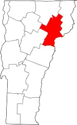 Map of Vermont highlighting Caledonia County | |
| Incorporated villages | ||
| CDPs | ||
| Unincorporated communities | ||