Sheshtamad County
Sheshtamad County (Persian: شهرستان ششتمد) is located in Razavi Khorasan province, Iran. Its capital is the city of Sheshtomad.
Sheshtamad County
Persian: شهرستان ششتمد | |
|---|---|
County | |
.svg.png.webp) Location of Sheshtamad County in Razavi Khorasan province | |
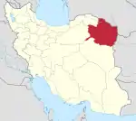
 Location of Razavi Khorasan province in Iran | |
| Coordinates: 35°48′N 57°57′E[1] | |
| Country | Iran |
| Province | Razavi Khorasan |
| Capital | Sheshtomad |
| Districts | Central, Shamkan |
| Area | |
| • Total | 2,937 km2 (1,134 sq mi) |
| Population (2016)[2] | |
| • Total | 24,261 |
| • Density | 8.3/km2 (21/sq mi) |
| Time zone | UTC+3:30 (IRST) |
At the 2006 census, the county's population (as Sheshtamad District of Sabzevar County) was 25,273 in 6,973 households.[3] The following census in 2011 counted 28,082 people in 8,437 households.[4] At the 2016 census, the district's population was 24,261 in 7,786 households.[2]
In February 2019, the district was separated from the county to establish Sheshtamad County and divided into two districts, each with two rural districts. The city of Sheshtomad became the new county's capital.[5] The village of Shamkan was later elevated to the status of a city and became the capital of Shamkan District.[6]
Administrative divisions
The population history of Sheshtamad County's administrative divisions (as Sheshtamad District of Sabzevar County) over three consecutive censuses is shown in the following table.
| Administrative Divisions | 2006[3] | 2011[4] | 2016[2] |
|---|---|---|---|
| Central District | 14,663 | 16,756 | 14,105 |
| Beyhaq Rural District | 7,417 | 7,826 | 6,871 |
| Takab-e Kuhmish Rural District | 5,000 | 4,758 | 4,126 |
| Sheshtomad (city) | 2,246 | 4,172 | 3,108 |
| Shamkan District | 10,610 | 11,326 | 10,156 |
| Rob-e Shamat Rural District | 4,663 | 4,806 | 4,385 |
| Shamkan Rural District | 5,947 | 6,520 | 5,771 |
| Shamkan (city)2 | |||
| Total | 25,273 | 28,082 | 24,261 |
| 1As a part of Sabzevar County at the 2006, 2011, and 2016 censuses 2Became a city after the 2016 census[6] | |||
References
- OpenStreetMap contributors (8 May 2023). "Sheshtamad County" (Map). OpenStreetMap. Retrieved 8 May 2023.
- "Census of the Islamic Republic of Iran, 1395 (2016)". AMAR (in Persian). The Statistical Center of Iran. p. 09. Archived from the original (Excel) on 2 April 2022. Retrieved 19 December 2022.
- "Census of the Islamic Republic of Iran, 1385 (2006)". AMAR (in Persian). The Statistical Center of Iran. p. 09. Archived from the original (Excel) on 20 September 2011. Retrieved 25 September 2022.
- "Census of the Islamic Republic of Iran, 1390 (2011)" (Excel). Iran Data Portal (in Persian). The Statistical Center of Iran. p. 09. Retrieved 19 December 2022.
- Jahangiri, Ishaq (21 February 2019). "Letter of approval regarding the country divisions of Razavi Khorasan province". RC Majlis (in Persian). Ministry of Interior, Council of Ministers. Archived from the original on 21 October 2020. Retrieved 8 May 2023.
- Vahidi, Ahmad. "The Minister of Interior agreed to convert two villages into cities". Rusta News (in Persian). Ministry of Interior. Archived from the original on 8 May 2023. Retrieved 8 May 2023.