Shirakamut
Shirakamut
Շիրակամուտ | |
|---|---|
.jpg.webp) Church in the village | |
 Shirakamut | |
| Coordinates: 40°51′38″N 44°09′10″E | |
| Country | |
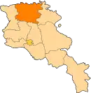
| Province | Lori |
| Elevation | 1,650 m (5,410 ft) |
| Population | |
| • Total | 2,310 |
| Time zone | UTC+4 (AMT) |
Shirakamut or previously Nalband (Armenian: Շիրակամուտ) is a village in the Lori Province of Armenia. The town was the epicenter of 1988 Armenian earthquake.
Toponymy
After the Ruso-Turkish war in 1830 several families, such as Yeranosyan, Yeghiayaryan, Naslyan, etc. left their native land Basen in Ayrarat province of the Great Hayq[2] and moved to the current area of Shirakamut or Nalband at the bank of Chichkhan river. The village is also known as Shirakarnut and previously as Nalband.
References
- Statistical Committee of Armenia. "The results of the 2011 Population Census of Armenia" (PDF).
- "Armenian nobility", Wikipedia, 2023-08-08, retrieved 2023-08-13
External links
Wikimedia Commons has media related to Cultural heritage monuments in Shirakamut, Lori.
- Shirakamut at GEOnet Names Server
- World Gazeteer: Armenia – World-Gazetteer.com
- Report of the results of the 2001 Armenian Census, Statistical Committee of Armenia
This article is issued from Wikipedia. The text is licensed under Creative Commons - Attribution - Sharealike. Additional terms may apply for the media files.