Shiroishi, Saga
Shiroishi (白石町, Shiroishi-chō) is a town located in south-central Saga Prefecture, Japan, in Kishima District. It is known for its vast reclaimed land and tidal flats of the Ariake Sea.
Shiroishi
白石町 | |
|---|---|
Town | |
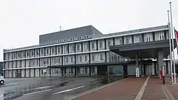
 Shiroishi town hall | |
 Flag  Seal | |
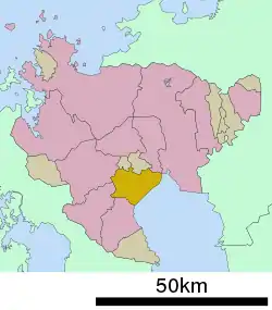
 Location of Shiroishi in Saga Prefecture | |
 Shiroishi Location in Japan | |
| Coordinates: 33°10′51″N 130°8′35″E | |
| Country | Japan |
| Region | Kyushu |
| Prefecture | Saga Prefecture |
| District | Kishima |
| Government | |
| • Mayor | Hiroaki Katafuchi |
| Area | |
| • Total | 99.46 km2 (38.40 sq mi) |
| Population (October 1, 2016) | |
| • Total | 23,606 |
| • Density | 240/km2 (610/sq mi) |
| Time zone | UTC+09:00 (JST) |
| City hall address | 253-1 Ōaza Sakata, Shiroishi-chō, Kishima-gun, Saga-ken 849-1292 |
| Climate | Cfa |
| Website | www |
| Symbols | |
| Flower | Iris |
| Tree | Sweet Osmanthus |
As of October 1, 2016, the town has an estimated population of 23,606.
On January 1, 2005 Shiroshi absorbed the towns of Fukudomi and Ariake, all from Kishima District, to become the new and expanded town of Shiroshi.
Geography
Terrain
Located in the Saga plains, Shiroishi is bordered by the Ariake Sea to the southeast. The port of Suminoe Bay, in the mouth of the Rokkaku River, has the largest tidal range in Japan with a maximum of about 6m at spring tide.
- Mountains: Mt. Kishima (345m), Mt. Inuyama (342m), Mt. Shiraiwa (340m), Mt. Iimori (318m)
- Rivers: Rokkaku River, Shioda River, Marie River, Tadae River
- Lakes: Nuinoike, Kasegawaike
- 85% of the total area of cultivated land is farmland.
Climate
- Annual Mean Air Temperature: 16.0 °C (60.8 °F)
- Annual Mean Precipitation: about 1,450 mm (57 in)
| Climate data for Shiroishi, Saga (1991−2020 normals, extremes 1977−present) | |||||||||||||
|---|---|---|---|---|---|---|---|---|---|---|---|---|---|
| Month | Jan | Feb | Mar | Apr | May | Jun | Jul | Aug | Sep | Oct | Nov | Dec | Year |
| Record high °C (°F) | 20.3 (68.5) |
22.9 (73.2) |
24.6 (76.3) |
31.5 (88.7) |
35.9 (96.6) |
37.5 (99.5) |
39.0 (102.2) |
38.6 (101.5) |
36.3 (97.3) |
33.1 (91.6) |
26.9 (80.4) |
24.2 (75.6) |
39.0 (102.2) |
| Average high °C (°F) | 9.9 (49.8) |
11.5 (52.7) |
15.1 (59.2) |
20.5 (68.9) |
25.5 (77.9) |
28.0 (82.4) |
31.3 (88.3) |
32.7 (90.9) |
29.1 (84.4) |
24.2 (75.6) |
18.1 (64.6) |
12.2 (54.0) |
21.5 (70.7) |
| Daily mean °C (°F) | 5.0 (41.0) |
6.2 (43.2) |
9.6 (49.3) |
14.5 (58.1) |
19.3 (66.7) |
23.1 (73.6) |
27.0 (80.6) |
27.6 (81.7) |
23.8 (74.8) |
18.1 (64.6) |
12.3 (54.1) |
7.0 (44.6) |
16.1 (61.0) |
| Average low °C (°F) | 0.6 (33.1) |
1.3 (34.3) |
4.3 (39.7) |
8.8 (47.8) |
13.8 (56.8) |
19.2 (66.6) |
23.6 (74.5) |
24.0 (75.2) |
19.7 (67.5) |
13.1 (55.6) |
7.3 (45.1) |
2.4 (36.3) |
11.5 (52.7) |
| Record low °C (°F) | −9.6 (14.7) |
−6.4 (20.5) |
−4.3 (24.3) |
−1.8 (28.8) |
3.9 (39.0) |
8.5 (47.3) |
15.5 (59.9) |
16.6 (61.9) |
7.0 (44.6) |
1.5 (34.7) |
−1.5 (29.3) |
−5.4 (22.3) |
−9.6 (14.7) |
| Average precipitation mm (inches) | 53.7 (2.11) |
71.3 (2.81) |
109.8 (4.32) |
145.1 (5.71) |
154.9 (6.10) |
309.5 (12.19) |
354.0 (13.94) |
219.4 (8.64) |
171.2 (6.74) |
88.8 (3.50) |
85.9 (3.38) |
59.4 (2.34) |
1,822.8 (71.76) |
| Average precipitation days (≥ 1.0 mm) | 8.1 | 8.3 | 10.1 | 9.3 | 8.9 | 13.2 | 12.9 | 10.0 | 9.0 | 6.2 | 8.2 | 7.8 | 112 |
| Mean monthly sunshine hours | 117.3 | 128.1 | 158.3 | 177.9 | 187.2 | 115.4 | 161.7 | 199.6 | 159.7 | 168.6 | 139.8 | 121.2 | 1,834.7 |
| Source: JMA[1][2] | |||||||||||||
History
- April 1, 1889 - The modern municipal system is established. At this time Shiroishi consists of nine separate villages: Hashishita, Fukudomi, Fukuji, Kinkō, Kita-Ariake, Minami-Ariake, Rokkaku, Ryūō, and Suko.
- April 1, 1936 - Fukuji gains town status and is renamed Shiroishi.
- April 1, 1955 - Kinkō and Ryūō merge to form Ariake.
- July 20, 1955 - Rokkaku and Suko are incorporated into Shiroishi.
- September 30, 1955 - Minami-Ariake is incorporated into Ariake.
- July 1, 1956 - Kita-Ariake is incorporated into Shiroishi.
- October 1, 1962 - Ariake gains town status.
- April 1, 1967 - Fukudomi gains town status.
- January 1, 2005 - The towns of Shiroishi, Fukudomi, and Ariake are merged under the name Shiroishi.
Demographics
27.01% of the population (7,437) are 65 or older. In 2005 there were 183 births and 322 deaths, 624 immigrants and 805 emigrants, indicating a negative population growth.
Economy
Education
High schools
(prefectural)
- Shiroishi High School
- Saga Agricultural School
Junior high schools
- Shiroishi Junior High School
- Fukudomi Junior High School
- Ariake Junior High School
Elementary schools
- Suko Elementary School
- Rokkaku Elementary School
- Shiroishi Elementary School
- Hokumei Elementary School
- Fukudomi Elementary School
- Ariake East Elementary School
- Ariake West Elementary School
- Ariake South Elementary School
Transportation
Air
The closest airports are Saga Airport and Fukuoka Airport.
Roads
- National Highways: Route 207 and Route 444.
- Prefectural Roads: Saga Prefecture Route 36
Festivals
- Yasaka Shrine Summer Festival (八坂神社 夏祭り, yasakajinja natsumatsuri), July 13 - Floats are pulled down the main shopping district in the tradition of the Kyoto Gion Festival.
- Hassaku (八朔), October 1 - A fall festival celebrating the sea at Kaidou Shrine.
- Okunchi (おくんち), October 19 - This fall festival is held at the Tsumayama, Rokkaku, Inasa, and Fukudomi shrines. It features Japanese horseback archery, called yabusame.
- Ohitaki Festival (お火たき祭り, ohitakimatsuri), December 26 - A bonfire festival where people pray for the coming year.
Notable Places
- Utagaki Park (歌垣公園, utagaki kouen), a park with many flowers.
- Suko Castle, A castle ruin in the Sengoku period. Ryūzōji Takanobu's residence.
- Inasa Shrine (稲佐神社, inasa jinja), an old shrine in the mountains west of Shiroishi. Of particular note is the stone paved road leading to the shrine.
- Fukudomi My Land Park (ふくどみマイランド公園, fukudomi mairando kouen) a park and playground.
People from Shioishi
References
- 観測史上1~10位の値(年間を通じての値). JMA. Retrieved February 27, 2022.
- 気象庁 / 平年値(年・月ごとの値). JMA. Retrieved February 27, 2022.
- 日本放送協会. "新たな特産品に レモンの新品種「璃の香」収穫始まる 白石町|NHK 佐賀県のニュース". NHK NEWS WEB. Retrieved 2022-10-21.
- "いちごさんワイン からつタクシー販売 | 経済 | 佐賀新聞ニュース". さがから by佐賀新聞 (in Japanese). Retrieved 2022-10-21.
External links
 Media related to Shiroishi, Saga at Wikimedia Commons
- Shiroishi official website