Slatiňany
Slatiňany (Czech pronunciation: [ˈslacɪɲanɪ]) is a town in Chrudim District in the Pardubice Region of the Czech Republic. It has about 4,200 inhabitants.
Slatiňany | |
|---|---|
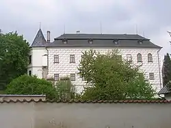
 Eastern wing of the Slatiňany Castle | |
 Flag  Coat of arms | |
 Slatiňany Location in the Czech Republic | |
| Coordinates: 49°55′16″N 15°48′50″E | |
| Country | |
| Region | Pardubice |
| District | Chrudim |
| First mentioned | 1294 |
| Government | |
| • Mayor | Jan Brůžek |
| Area | |
| • Total | 15.61 km2 (6.03 sq mi) |
| Elevation | 268 m (879 ft) |
| Population (2023-01-01)[1] | |
| • Total | 4,210 |
| • Density | 270/km2 (700/sq mi) |
| Time zone | UTC+1 (CET) |
| • Summer (DST) | UTC+2 (CEST) |
| Postal code | 538 21 |
| Website | www |
Administrative parts
Villages of Kochánovice, Kunčí, Škrovád and Trpišov are administrative parts of Slatiňany.
Geography
Slatiňany is located about 3 kilometres (2 mi) south of Chrudim and 12 km (7 mi) south of Pardubice. The eastern part of the municipal territory with the town proper lies in the Svitavy Uplands, the western part lies in the Iron Mountains. The highest point is the hill Hůra at 392 m (1,286 ft) above sea level. The Chrudimka River flows through the town.
History
The first written mention of Slatiňany is from 1294. A wooden Gothic fortress on a promontory above the Chrudimka was documented in 1371. In the 19th century, during the rule of the noble Auersperg family, the village of Slatiňany economically developed. In the late 19th and early 20th centuries, it became an industrial centre with sugar factory, distillery and fertilizer factory. In 1971, it was promoted to a town.[2]
Demographics
|
|
| ||||||||||||||||||||||||||||||||||||||||||||||||||||||
| Source: Censuses[3][4] | ||||||||||||||||||||||||||||||||||||||||||||||||||||||||
Sights
.jpg.webp)
The main landmark is the Slatiňany Castle with a 16 ha (40-acre) large English park.[2] it was originally a neo-Gothic fortress, rebuilt into a Renaissance castle. During the rule of the Auersperg family after 1746, the castle became the administrative centre of the estate and was converted into a comfortable summer residence with a park. The castle and park create a very valuable set of monuments, protected as a national cultural monument. Among the most valuable elements are the baroque and romantic interiors and the castle stud farm, built in 1894–1898. This former stud farm now houses the Museum of Kladruber. The park is also decorated with Kočičí hrádek, which is 1:5 scale miniature of a castle.[5]
Notable people
- Helena Vondráčková (born 1947), singer; raised here
References
- "Population of Municipalities – 1 January 2023". Czech Statistical Office. 2023-05-23.
- "O městě" (in Czech). Město Slatiňany. Retrieved 2021-10-20.
- "Historický lexikon obcí České republiky 1869–2011 – Okres Chrudim" (in Czech). Czech Statistical Office. 2015-12-21. pp. 17–18.
- "Population Census 2021: Population by sex". Public Database. Czech Statistical Office. 2021-03-27.
- "Zámek Slatiňany" (in Czech). National Heritage Institute. Retrieved 2023-06-15.
- "Ozvěny Slatiňan 11/2021" (PDF) (in Czech). Město Slatiňany. November 2021. p. 4. Retrieved 2023-08-06.
- "Ozvěny Slatiňan 06/2020" (PDF) (in Czech). Město Slatiňany. June 2020. p. 3. Retrieved 2023-08-06.