Chrudim District
Chrudim District (Czech: okres Chrudim) is a district in the Pardubice Region of the Czech Republic. Its capital is the town of Chrudim.
Chrudim District
Okres Chrudim | |
|---|---|
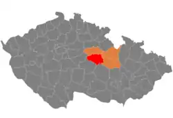 Location in the Pardubice Region within the Czech Republic | |
| Coordinates: 49°52′N 15°54′E | |
| Country | |
| Region | Pardubice |
| Capital | Chrudim |
| Area | |
| • Total | 992.89 km2 (383.36 sq mi) |
| Population (2023)[2] | |
| • Total | 106,398 |
| • Density | 110/km2 (280/sq mi) |
| Time zone | UTC+1 (CET) |
| • Summer (DST) | UTC+2 (CEST) |
| Municipalities | 108 |
| * Towns | 13 |
| * Market towns | 5 |
Administrative division
Chrudim District is divided into two administrative districts of municipalities with extended competence: Chrudim and Hlinsko.
List of municipalities
Towns are marked in bold and market towns in italics:
Chrudim - Běstvina - Biskupice - Bítovany - Bojanov - Bor u Skutče - Bořice - Bousov - Bylany - Ctětín - Čankovice - České Lhotice - Chrast - Chroustovice - Dědová - Dolní Bezděkov - Dřenice - Dvakačovice - Hamry - Heřmanův Městec - Hlinsko - Hluboká - Hodonín - Holetín - Honbice - Horka - Horní Bradlo - Hošťalovice - Hrochův Týnec - Hroubovice - Jeníkov - Jenišovice - Kameničky - Kladno - Klešice - Kněžice - Kočí - Kostelec u Heřmanova Městce - Krásné - Křižanovice - Krouna - Lány - Leštinka - Libkov - Liboměřice - Licibořice - Lipovec - Lozice - Lukavice - Luže - Míčov-Sušice - Miřetice - Mladoňovice - Morašice - Mrákotín - Nabočany - Načešice - Nasavrky - Orel - Ostrov - Otradov - Perálec - Podhořany u Ronova - Pokřikov - Prachovice - Předhradí - Přestavlky - Proseč - Prosetín - Raná - Rabštejnská Lhota - Řestoky - Ronov nad Doubravou - Rosice - Rozhovice - Seč - Skuteč - Slatiňany - Smrček - Sobětuchy - Stolany - Střemošice - Studnice - Svídnice - Svratouch - Tisovec - Třemošnice - Trhová Kamenice - Třibřichy - Trojovice - Tuněchody - Úherčice - Úhřetice - Vápenný Podol - Včelákov - Vejvanovice - Vítanov - Vojtěchov - Vortová - Vrbatův Kostelec - Všeradov - Vysočina - Vyžice - Zaječice - Zájezdec - Zderaz - Žlebské Chvalovice - Žumberk
Geography
.jpg.webp)
The landscape consists of two distinct parts. Towards the south the district is hilly and mostly forested, in the north it is flatter and deforested. The territory extends into five geomorphological mesoregions: Iron Mountains (most of the territory), Svitavy Uplands (north), Central Elbe Table (a small part in the west), Upper Sázava Hills (a small part in the west) and East Elbe Table (a small part in the northeast). The highest point of the district is the hill Karlštejn in Svratouch with an elevation of 784 m (2,572 ft), the lowest point is the river bed of the Chrudimka in Úhřetice at 230 m (750 ft).
From the total district area of 992.9 km2 (383.4 sq mi), agricultural land occupies 602.1 km2 (232.5 sq mi), forests occupy 288.1 km2 (111.2 sq mi), and water area occupies 15.4 km2 (5.9 sq mi). Forests cover 29.0% of the district's area.[1]
The most important river is the Chrudimka, which flows across the district from south to north. The largest body of water is Seč Reservoir with an area of 220 ha (540 acres).
Two protected landscape areas extend into the district: Iron Mountains in the east and Žďárské vrchy in the south.
Demographics
|
|
| ||||||||||||||||||||||||||||||||||||||||||||||||||||||
| Source: Censuses[3][4] | ||||||||||||||||||||||||||||||||||||||||||||||||||||||||
Most populated municipalities
| Name | Population[2] | Area (km2) |
|---|---|---|
| Chrudim | 23,443 | 33 |
| Hlinsko | 9,596 | 24 |
| Skuteč | 5,071 | 35 |
| Heřmanův Městec | 4,912 | 14 |
| Slatiňany | 4,210 | 16 |
| Třemošnice | 3,250 | 19 |
| Chrast | 3,159 | 18 |
| Luže | 2,613 | 31 |
| Hrochův Týnec | 2,272 | 13 |
| Proseč | 2,096 | 34 |
Economy
The largest employers with headquarters in Chrudim District and at least 500 employees are:[5]
| Economic entity | Location | Number of employees | Main activity |
|---|---|---|---|
| Arriva Autobusy | Chrudim | 1,000–1,499 | Urban and suburban passenger transport |
| Hamzova odborná léčebna pro děti a dospělé | Luže | 500–999 | Health care |
| Alukov | Orel | 500–999 | Manufacture of roofing |
| DAKO-CZ | Třemošnice | 500–999 | Manufacture of braking systems for rolling stock |
| Kovolis Hedvikov | Třemošnice | 500–999 | Casting of metals |
Transport
With the exception of a short section of the D35 motorway in the northernmost part of the district, there are no other motorways. The most important road is the I/37 road from Pardubice to Ždírec nad Doubravou.
Sights

The most important monuments in the district, protected as national cultural monuments, are:[6]
- Ležáky area
- Slatiňany Castle
- Church of Saint Bartholomew in Kočí
- Church of Our Lady Help of Christians on Chlumek
The best-preserved settlements and landscapes, protected as monument reservations and monument zones, are:[7]
- Hlinsko-Betlém (monument reservation)
- České Lhotice archaeological site (monument reservation)
- Chrast
- Chrudim
- Heřmanův Městec
- Luže
- Předhradí
- Svobodné Hamry
- Slatiňansko-Slavicko landscape
The most visited tourist destinations are the Vysočina Open Air Museum in Hlinsko, Slatiňany Castle, and Museum of Puppetry Culture in Chrudim.[8]
Notable people
References
- "Land use (as at 31 December)". Public database. Czech Statistical Office. Retrieved 2023-05-16.
- "Population of Municipalities – 1 January 2023". Czech Statistical Office. 2023-05-23.
- "Historický lexikon obcí České republiky 1869–2011 – Okres Chrudim" (in Czech). Czech Statistical Office. 2015-12-21. pp. 1–2.
- "Population Census 2021: Population by sex". Public Database. Czech Statistical Office. 2021-03-27.
- "Registr ekonomických subjektů". Business Register (in Czech). Czech Statistical Office. Retrieved 2023-05-10.
- "Výsledky vyhledávání: Národní kulturní památky, okres Chrudim". Ústřední seznam kulturních památek (in Czech). National Heritage Institute. Retrieved 2023-05-10.
- "Výsledky vyhledávání: Památkové rezervace, Památkové zóny, okres Chrudim". Ústřední seznam kulturních památek (in Czech). National Heritage Institute. Retrieved 2023-05-10.
- "Turisté mají v České republice nejraději zoologické zahrady, technické památky, koupání a Pražský hrad" (in Czech). CzechTourism. 2022-06-24. Retrieved 2023-05-10.
External links
- Chrudim District – profile on the Czech Statistical Office website