Ústí nad Orlicí District
Ústí nad Orlicí District (Czech: okres Ústí nad Orlicí) is a district in the Pardubice Region of the Czech Republic. Its capital is the town of Ústí nad Orlicí, but the most populated town is Česká Třebová.
Ústí nad Orlicí District
Okres Ústí nad Orlicí | |
|---|---|
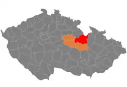 Location in the Pardubice Region within the Czech Republic | |
| Coordinates: 50°2′N 16°30′E | |
| Country | |
| Region | Pardubice |
| Capital | Ústí nad Orlicí |
| Area | |
| • Total | 1,267.46 km2 (489.37 sq mi) |
| Population (2023)[2] | |
| • Total | 138,250 |
| • Density | 110/km2 (280/sq mi) |
| Time zone | UTC+1 (CET) |
| • Summer (DST) | UTC+2 (CEST) |
| Municipalities | 115 |
| * Towns | 10 |
| * Market towns | 4 |
Administrative division
Ústí nad Orlicí District is divided into six administrative districts of municipalities with extended competence: Ústí nad Orlicí, Česká Třebová, Králíky, Lanškroun, Vysoké Mýto and Žamberk.
List of municipalities
Towns are marked in bold and market towns in italics:
Albrechtice – Anenská Studánka – Běstovice – Bošín – Brandýs nad Orlicí – Bučina – Bystřec – Čenkovice – Červená Voda – Česká Rybná – Česká Třebová – České Heřmanice – České Libchavy – České Petrovice – Choceň – Cotkytle – Damníkov – Dlouhá Třebová – Dlouhoňovice – Dobříkov – Dolní Čermná – Dolní Dobrouč – Dolní Morava – Džbánov – Hejnice – Helvíkovice – Hnátnice – Horní Čermná – Horní Heřmanice – Horní Třešňovec – Hrádek – Hrušová – Jablonné nad Orlicí – Jamné nad Orlicí – Javorník – Jehnědí – Kameničná – Klášterec nad Orlicí – Koldín – Kosořín – Králíky – Krasíkov – Kunvald – Lanškroun – Leština – Letohrad – Libecina – Libchavy – Lichkov – Líšnice – Lubník – Lukavice – Luková – Mistrovice – Mladkov – Mostek – Nasavrky – Nekoř – Nové Hrady – Orlické Podhůří – Orličky – Ostrov – Oucmanice – Pastviny – Petrovice – Písečná – Plchovice – Podlesí – Přívrat – Pustina – Radhošť – Řepníky – Řetová – Řetůvka – Rudoltice – Rybník – Sázava – Seč – Šedivec – Semanín – Skořenice – Slatina – Sobkovice – Sopotnice – Sruby – Stradouň – Strážná – Studené – Sudislav nad Orlicí – Sudslava – Svatý Jiří – Tatenice – Těchonín – Tisová – Třebovice – Trpík – Týnišťko – Újezd u Chocně – Ústí nad Orlicí – Velká Skrovnice – Verměřovice – Vinary – Voděrady – Vraclav – Vračovice-Orlov – Výprachtice – Vysoké Mýto – Záchlumí – Zádolí – Zálší – Žamberk – Žampach – Zámrsk – Zářecká Lhota – Žichlínek
Geography
Ústí nad Orlicí District borders Poland in the north. In lies mostly in the historical land of Bohemia, but the eastern edge lies in Moravia.
The landscape is very rugged and varied. While in the west there are plains, in the east there is mountainous terrain. The territory extends into eight geomorphological mesoregions: Svitavy Uplands (west), Orlice Table (northwest), Orlické Foothills (centre), Orlické Mountains (north), Zábřeh Highlands (southeast), Hanušovice Highlands (east), Snieznik Mountains (northeast), and Kłodzko Valley (a narrow strip in the east). The highest point of the district and of the entire Pardubice Region is the Králický Sněžník mountain in Dolní Morava with an elevation of 1,423 m (4,669 ft). The lowest point is the river bed of the Loučná in Radhošť at 244 m (801 ft).
From the total district area of 1,267.5 km2 (489.4 sq mi), agricultural land occupies 744.1 km2 (287.3 sq mi), forests occupy 404.4 km2 (156.1 sq mi), and water area occupies 14.5 km2 (5.6 sq mi). Forests cover 31.9% of the district's area.[1]
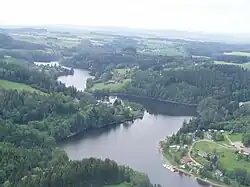
The longest river in the district is the Tichá Orlice. The Morava River originates here, but soon leaves the territory. Other notable rivers in the district are the Divoká Orlice, Loučná, Moravská Sázava and Třebovka. Apart from the western part of the district, there are not many bodies of water. The largest body of water is Pastviny Reservoir with an area of about 110 ha (270 acres).[3]
There are no large-scale protected areas.
Demographics
|
|
| ||||||||||||||||||||||||||||||||||||||||||||||||||||||
| Source: Censuses[4][5] | ||||||||||||||||||||||||||||||||||||||||||||||||||||||||
Most populated municipalities
| Name | Population[2] | Area (km2) |
|---|---|---|
| Česká Třebová | 15,203 | 41 |
| Ústí nad Orlicí | 14,141 | 36 |
| Vysoké Mýto | 12,333 | 42 |
| Lanškroun | 9,709 | 21 |
| Choceň | 8,708 | 22 |
| Letohrad | 6,503 | 24 |
| Žamberk | 5,951 | 17 |
| Králíky | 4,143 | 53 |
| Jablonné nad Orlicí | 3,023 | 4 |
| Červená Voda | 2,970 | 47 |
Economy
The largest employers with headquarters in Ústí nad Orlicí District and at least 500 employees are:[6]
| Economic entity | Location | Number of employees | Main activity |
|---|---|---|---|
| Iveco Czech Republic | Vysoké Mýto | 3,000–3,999 | Manufacture of motor vehicles |
| Kyocera AVX Component | Lanškroun | 2,000–2,499 | Manufacture of electronic components |
| OEZ | Letohrad | 1,500–1,999 | Manufacture of electricity distribution and control apparatus |
| Schaeffler Production CZ | Lanškroun | 1,000–1,499 | Manufacture of rolling element bearings |
| CZ LOKO | Česká Třebová | 500–999 | Manufacture and repair of rolling stock |
| Autoneum CZ | Choceň | 500–999 | Manufacture of automotive parts |
| Schott CR | Lanškroun | 500–999 | Manufacture of electronic components |
| SOR Libchavy | Libchavy | 500–999 | Manufacture of motor vehicles |
| Konzum, obchodní družstvo v Ústí nad Orlicí | Ústí nad Orlicí | 500–999 | Retail trade |
| Rieter CZ | Ústí nad Orlicí | 500–999 | Manufacture of textile machinery |
Transport
There are no motorways passing through the district. The most important road is the I/35 road (part of the European route E442), which replaces the unfinished section of the D35 motorway from Olomouc to the Hradec Králové Region.
Sights
The most important monuments in the district, protected as national cultural monuments, are:[7]
- Theatre in Ústí nad Orlicí
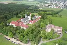
- Hora Matky Boží pilgrimage site in Králíky with the Church of the Assumption of the Virgin Mary
The best-preserved settlements, protected as monument zones, are:[8]
The four most visited tourist destinations of the Pardubice Region are located in Ústí nad Orlicí District, and the first three in Dolní Morava. These most visited tourist destinations are Sky Walk Observation Tower, Mammoth Alpine Coaster, children's amusement parks, and the Hora Matky Boží pilgrimage site in Králíky.[9]
Notable people
References
- "Land use (as at 31 December)". Public database. Czech Statistical Office. Retrieved 2023-05-16.
- "Population of Municipalities – 1 January 2023". Czech Statistical Office. 2023-05-23.
- "Vodní nádrž Pastviny" (in Czech). InfoČesko. Retrieved 2023-05-16.
- "Historický lexikon obcí České republiky 1869–2011 – Okres Ústí nad Orlicí" (in Czech). Czech Statistical Office. 2015-12-21. pp. 1–2.
- "Population Census 2021: Population by sex". Public Database. Czech Statistical Office. 2021-03-27.
- "Registr ekonomických subjektů". Business Register (in Czech). Czech Statistical Office. Retrieved 2023-05-16.
- "Výsledky vyhledávání: Národní kulturní památky, okres Ústí nad Orlicí". Ústřední seznam kulturních památek (in Czech). National Heritage Institute. Retrieved 2023-05-16.
- "Výsledky vyhledávání: Památkové rezervace, Památkové zóny, okres Ústí nad Orlicí". Ústřední seznam kulturních památek (in Czech). National Heritage Institute. Retrieved 2023-05-16.
- "Turisté mají v České republice nejraději zoologické zahrady, technické památky, koupání a Pražský hrad" (in Czech). CzechTourism. 2022-06-24. Retrieved 2023-05-16.
External links
- Ústí nad Orlicí District – profile on the Czech Statistical Office website