Dlouhoňovice
Dlouhoňovice is a municipality and village in Ústí nad Orlicí District in the Pardubice Region of the Czech Republic. It has about 800 inhabitants.
Dlouhoňovice | |
|---|---|
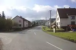 Main road | |
 Flag  Coat of arms | |
 Dlouhoňovice Location in the Czech Republic | |
| Coordinates: 50°4′13″N 16°26′30″E | |
| Country | |
| Region | Pardubice |
| District | Ústí nad Orlicí |
| First mentioned | 1543 |
| Area | |
| • Total | 3.90 km2 (1.51 sq mi) |
| Elevation | 416 m (1,365 ft) |
| Population (2023-01-01)[1] | |
| • Total | 819 |
| • Density | 210/km2 (540/sq mi) |
| Time zone | UTC+1 (CET) |
| • Summer (DST) | UTC+2 (CEST) |
| Postal code | 564 01 |
| Website | www |
Etymology
The name is probably derived from dlouhé hony, which meant long narrow fields.[2]
Geography
Dlouhoňovice is located about 11 kilometres (7 mi) north of Ústí nad Orlicí and 46 km (29 mi) east of Pardubice. It lies in the Orlické Foothills. The highest point is at 510 m (1,670 ft) above sea level.
History
The village was probably founded in the 14th century.[2]
Transport
The railway station named Žamberk, which serves this town, is located in the territory of Dlouhoňovice. It lies on the railway line heading from Hradec Králové to Letohrad.[3]
Sights
There are no protected cultural monuments in the municipality.[4]
References
- "Population of Municipalities – 1 January 2023". Czech Statistical Office. 2023-05-23.
- "Historie obce" (in Czech). Obec Dlouhoňovice. Retrieved 2023-06-28.
- "Detail stanice Žamberk" (in Czech). České dráhy. Retrieved 2023-05-17.
- "Výsledky vyhledávání: Kulturní památky, obec Dlouhoňovice". Ústřední seznam kulturních památek (in Czech). National Heritage Institute. Retrieved 2023-06-28.
This article is issued from Wikipedia. The text is licensed under Creative Commons - Attribution - Sharealike. Additional terms may apply for the media files.