Sourdeval
Sourdeval (French pronunciation: [suʁdəval]) is a commune in the Manche department in Normandy in north-western France. On 1 January 2016, the former commune of Vengeons was merged into Sourdeval.[3]
Sourdeval | |
|---|---|
 | |
Location of Sourdeval | |
 Sourdeval  Sourdeval | |
| Coordinates: 48°43′26″N 0°55′11″W | |
| Country | France |
| Region | Normandy |
| Department | Manche |
| Arrondissement | Avranches |
| Canton | Le Mortainais |
| Intercommunality | CA Mont-Saint-Michel-Normandie |
| Government | |
| • Mayor (2020–2026) | Sophie Laurent[1] |
| Area 1 | 51.87 km2 (20.03 sq mi) |
| Population | 3,113 |
| • Density | 60/km2 (160/sq mi) |
| Demonym | Sourdevalais |
| Time zone | UTC+01:00 (CET) |
| • Summer (DST) | UTC+02:00 (CEST) |
| INSEE/Postal code | 50582 /50150 |
| Elevation | 155–354 m (509–1,161 ft) (avg. 220 m or 720 ft) |
| Website | sourdeval.fr |
| 1 French Land Register data, which excludes lakes, ponds, glaciers > 1 km2 (0.386 sq mi or 247 acres) and river estuaries. | |
Heraldry
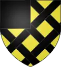 Arms of Sourdeval |
The arms of Sourdeval are blazoned : Or fretty sable, a canton of the second.
|
See also
References
- "Répertoire national des élus: les maires" (in French). data.gouv.fr, Plateforme ouverte des données publiques françaises. 13 September 2022.
- "Populations légales 2020". The National Institute of Statistics and Economic Studies. 29 December 2022.
- Arrêté préfectoral 22/31 December 2015 (in French)
Wikimedia Commons has media related to Sourdeval.
This article is issued from Wikipedia. The text is licensed under Creative Commons - Attribution - Sharealike. Additional terms may apply for the media files.