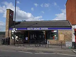
South Ealing tube station
South Ealing tube station is a London Underground station in the London Borough of Ealing. The station is on the Heathrow Airport branch of the Piccadilly line, between Acton Town and Northfields stations.[6] It is located on South Ealing Road and is in Travelcard Zone 3.[6]
| South Ealing | |
|---|---|
 | |
 South Ealing Location of South Ealing in Greater London | |
| Location | Ealing |
| Local authority | London Borough of Ealing |
| Managed by | London Underground |
| Number of platforms | 4 |
| Fare zone | 3 |
| London Underground annual entry and exit | |
| 2018 | |
| 2019 | |
| 2020 | |
| 2021 | |
| 2022 | |
| Railway companies | |
| Original company | District Railway |
| Key dates | |
| 1 May 1883 | Station opened |
| 29 April 1935 | Piccadilly line service introduced |
| 1964 | District line service withdrawn |
| Other information | |
| External links | |
| WGS84 | 51.50111°N 0.30722°W |
Station information
South Ealing tube station has a waiting room.[7]
The station does not offer step-free access from the train or platform to street level.[6]
Like all other London Underground stations, South Ealing has a Labyrinth artwork by Mark Wallinger, in place since 2013.[8]
History
South Ealing station was opened as a stop on the District Railway (later the District line) on 1 May 1883. These trains were initially steam-powered, but the line has been electrified since 1905.
The station has been served by the Piccadilly line since 29 April 1935. It was modernised between 1935 and 1936, with the original buildings replaced, the eastbound platform receiving a new concrete canopy and waiting room and electric lights being installed.[10]
The District line service was withdrawn in 1964.[10]
The station building was again replaced in 1983.[10] It was refurbished once more in 2006.[8]
Gallery
 Piccadilly Line train approaching South Ealing
 Piccadilly Line train leaving South Ealing, headed westwards.
 1973 Stock passing.
.jpg.webp) Eastbound platform building.
Eastbound platform building. Waiting enclosure of glass & metal.
References
- "Station Usage Data" (CSV). Usage Statistics for London Stations, 2018. Transport for London. 23 September 2020. Archived from the original on 14 January 2023. Retrieved 11 October 2023.
- "Station Usage Data" (XLSX). Usage Statistics for London Stations, 2019. Transport for London. 23 September 2020. Archived from the original on 9 November 2020. Retrieved 9 November 2020.
- "Station Usage Data" (XLSX). Usage Statistics for London Stations, 2020. Transport for London. 16 April 2021. Retrieved 1 January 2022.
- "Station Usage Data" (XLSX). Usage Statistics for London Stations, 2021. Transport for London. 12 July 2022. Retrieved 7 September 2022.
- "Station Usage Data" (XLSX). Usage Statistics for London Stations, 2022. Transport for London. 4 October 2023. Retrieved 10 October 2023.
- Standard Tube Map (PDF) (Map). Not to scale. Transport for London. November 2022. Archived (PDF) from the original on 7 November 2022. Retrieved 12 November 2022.
- "South Ealing Underground Station". Transport for London. Retrieved 28 March 2020.
- "Labyrinth 260/270 – South Ealing". art.tfl.gov.uk. 14 May 2013. Retrieved 28 March 2020.
- "Buses from South Ealing" (PDF). TfL. 29 April 2023. Retrieved 5 May 2023.
- Wallinger, Mark (2014). Labyrinth – A Journey Through London's Underground. Art / Books. p. 287. ISBN 978-1-908970-16-9.
External links
| Preceding station | Following station | |||
|---|---|---|---|---|
| Northfields | Piccadilly line | Acton Town towards Cockfosters or Arnos Grove | ||
| Former services | ||||
| Preceding station | Following station | |||
| Boston Manor towards Hounslow Town or Hounslow Barracks |
District line (1883–1908) |
Acton Town towards Whitechapel or Upminster | ||
| Northfields towards Hounslow Town or Hounslow West |
District line (1908–1964) |
Acton Town towards Upminster | ||