Santa Cruz, Manila
Santa Cruz is a district in the northern part of the City of Manila, Philippines, located on the right bank of the Pasig River near its mouth, bordered by the districts of Tondo, Binondo, Quiapo, and Sampaloc, as well as the areas of Grace Park and Barrio San Jose in Caloocan and the district of La Loma in Quezon City. The district belongs to the 3rd congressional district of Manila.
Santa Cruz | |
|---|---|
District of Manila | |
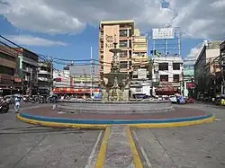 Carriedo Fountain at Plaza Santa Cruz | |
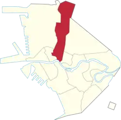 Map of Manila showing the location of Santa Cruz | |
| Coordinates: 14.5998366°N 120.9801955°E | |
| Country | Philippines |
| Region | National Capital Region |
| City | Manila |
| District | Part of the 3rd district of Manila |
| Population (2020)[1] | |
| • Total | 126,735 |
| ZIP code | 1003 (Santa Cruz South) 1014 (Santa Cruz North) |
History
Spanish colonial era
Prior to the arrival of the Spanish conquistadors to the Philippine Islands, the district of Santa Cruz was partly a marshland, patches of greeneries, orchards and partly rice fields. A Spanish expedition in 1581 claimed the territory and awarded to the Society of Jesus whose members are known as 'Jesuits'.
The Jesuits built the first Roman Catholic church in the area where the present Santa Cruz Parish stands on June 20, 1619. The Jesuits enshrined the image of the Our Lady of The Pillar in 1643 to serve the pre-dominantly Chinese residents in the area. The image drew a lot of devotees and a popular cult grew around it.
On June 24, 1784, King Carlos III of Spain gave the deeds to about 2 km2 (0.77 sq mi) of land that was part of the Hacienda de Mayhaligue to the San Lazaro Hospital which served as a caring home for lepers in Manila at that time.
At the Santa Cruz Parish, a small park was built that linked the area into the headquarters of the Spanish cavalry, the building that once was the Colegio de San Ildefonso, operated by the Jesuits. The district in the Spanish times also had a slaughter house and a meat market and up north was the Chinese cemetery.
The Franciscan fathers were given the responsibility to care for the lepers of the city and specifically the San Lazaro Hospital. Father Felix Huerta developed San Lazaro into a refuge for the afflicted and it became a famous home for those afflicted in the north side of the Pasig River.
World War II
During World War II, the Japanese occupational forces, caught unaware of the fast approaching liberation by the combined American & Filipino soldiers from the north, abandoned in 1945 the northern banks of the Pasig River including Santa Cruz. Santa Cruz and much of the northern portions of Manila were spared from the artillery bombardment and to date, a number of pre-World War II buildings and houses still stand in Santa Cruz.
When the Philippine republic was finally established in July 1946, the San Lazaro Hospital complex became the head office of the country’s Department of Health.
Notable buildings

Santa Cruz Church
The first Santa Cruz Church was built when the Arrabal (Suburb) of Santa Cruz was established by the Jesuits in the early 1600s. The church had undergone many repairs and reconstruction, with the last reconstruction done in the 1950s. Today, the church architecture employs a California Spanish Mission style facade silhouette with the usual Filipino (Asian-Hispanic mix) Baroque ornamentation. The church facade is topped with an effigy statue of Our Lady of the Pillar, the patroness of the church whose feast happens every third Sunday of October and on the 12th day of October.
Cemeteries
Santa Cruz is home to Manila's oldest cemeteries located in the district's northern section namely, La Loma Cemetery (shared with Caloocan), the Manila Chinese Cemetery, and the city's biggest, the Manila North Cemetery.
Main thoroughfares
Rizal Avenue is the main thoroughfare in the district. The district is also accessible via the following roads:
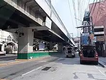
Stations of the LRT Line 1 located in Santa Cruz are Carriedo (shared with Quiapo), Doroteo Jose, Bambang, Tayuman and Blumentritt (shared with Tondo). The Philippine National Railways has a station in Blumentritt. Jeepneys coming from Baclaran, Pasay, Valenzuela, Novaliches and Caloocan pass through Rizal Avenue.
Barangays
Santa Cruz has 82 barangays.
| Zone/Barangay | Land area (km²) | Population (2020 census) |
| Zone 29 | ||
| Barangay 297 | 0.03272 km² | 2,005 |
| Barangay 298 | 0.03450 km² | 1,020 |
| Barangay 299 | 0.03215 km² | 1,300 |
| Barangay 300 | 0.01291 km² | 981 |
| Barangay 301 | 0.01767 km² | 448 |
| Barangay 302 | 0.01031 km² | 654 |
| Barangay 303 | 0.06499 km² | 641 |
| Barangay 304 | 0.02792 km² | 298 |
| Barangay 305 | 0.03740 km² | 645 |
| Zone 31 | ||
| Barangay 310 | 0.08649 km² | 13,602 |
| Barangay 311 | 0.04576 km² | 2,401 |
| Barangay 312 | 0.03626 km² | 3,328 |
| Barangay 313 | 0.05434 km² | 2,848 |
| Barangay 314 | 0.05279 km² | 2,064 |
| Zone 32 | ||
| Barangay 315 | 0.06805 km² | 1,786 |
| Barangay 316 | 0.01934 km² | 829 |
| Barangay 317 | 0.02480 km² | 1,542 |
| Barangay 318 | 0.01268 km² | 740 |
| Barangay 319 | 0.01705 km² | 1,209 |
| Barangay 320 | 0.02429 km² | 1,300 |
| Barangay 321 | 0.01300 km² | 240 |
| Barangay 322 | 0.01519 km² | 799 |
| Barangay 323 | 0.02378 km² | 1,060 |
| Barangay 324 | 0.01246 km² | 605 |
| Barangay 325 | 0.009850 km² | 522 |
| Zone 33 | ||
| Barangay 326 | 0.01226 km² | 825 |
| Barangay 327 | 0.03052 km² | 1,239 |
| Barangay 328 | 0.01152 km² | 679 |
| Barangay 329 | 0.01629 km² | 439 |
| Barangay 330 | 0.02729 km² | 2,244 |
| Barangay 331 | 0.1383 km² | 924 |
| Barangay 332 | 0.01247 km² | 582 |
| Barangay 333 | 0.01653 km² | 877 |
| Barangay 334 | 0.03035 km² | 1,461 |
| Barangay 335 | 0.02878 km² | 1,350 |
| Zone 34 | ||
| Barangay 336 | 0.03266 km² | 2,134 |
| Barangay 337 | 0.02884 km² | 1,386 |
| Barangay 338 | 0.02865 km² | 1,378 |
| Barangay 339 | 0.02748 km² | 1,265 |
| Barangay 340 | 0.02861 km² | 2,009 |
| Barangay 341 | 0.03320 km² | 1,463 |
| Barangay 342 | 0.05714 km² | 1,634 |
| Barangay 343 | 0.04155 km² | 2,209 |
| Zone 35 | ||
| Barangay 344 | 0.03498 km² | 536 |
| Barangay 345 | 0.02953 km² | 1,149 |
| Barangay 346 | 0.02944 km² | 1,511 |
| Barangay 347 | 0.02963 km² | 1,266 |
| Barangay 348 | 0.02268 km² | 1,249 |
| Barangay 349 | 0.01395 km² | 788 |
| Barangay 350 | 0.1555 km² | 6,776 |
| Barangay 351 | 0.05098 km² | 3,401 |
| Barangay 352 | 0.03569 km² | 1,342 |
| Zone 36 | ||
| Barangay 353 | 0.04906 km² | 2,232 |
| Barangay 354 | 0.04162 km² | 1,810 |
| Barangay 355 | 0.04534 km² | 970 |
| Barangay 356 | 0.02078 km² | 505 |
| Barangay 357 | 0.02063 km² | 736 |
| Barangay 358 | 0.02023 km² | 1,029 |
| Barangay 359 | 0.01921 km² | 410 |
| Barangay 360 | 0.03144 km² | 741 |
| Barangay 361 | 0.02054 km² | 715 |
| Barangay 362 | 0.01722 km² | 252 |
| Zone 37 | ||
| Barangay 363 | 0.02382 km² | 559 |
| Barangay 364 | 0.02242 km² | 1,985 |
| Barangay 365 | 0.01923 km² | 1,278 |
| Barangay 366 | 0.02240 km² | 1,193 |
| Barangay 367 | 0.03112 km² | 1,708 |
| Barangay 368 | 0.02616 km² | 1,337 |
| Barangay 369 | 0.02241 km² | 1,396 |
| Barangay 370 | 0.02005 km² | 772 |
| Barangay 371 | 0.02486 km² | 842 |
| Barangay 372 | 0.5443 km² | 4,136 |
| Zone 38 | ||
| Barangay 373 | 0.01963 km² | 3,788 |
| Barangay 374 | 0.02657 km² | 3,277 |
| Barangay 375 | 0.01737 km² | 3,909 |
| Barangay 376 | 0.04343 km² | 930 |
| Barangay 377 | 0.01518 km² | 578 |
| Barangay 378 | 0.02461 km² | 602 |
| Barangay 379 | 0.009460 km² | 654 |
| Barangay 380 | 0.01454 km² | 921 |
| Barangay 381 | 0.02978 km² | 1,591 |
| Barangay 382 | 0.03314 km² | 896 |
Sub-districts
Barangays
| Zone | Barangays |
| Zone 29 | Barangays 297, 298, 299, 300, 301, 302, 303, 304, and 305 |
| Zone 31 | Barangays 310, 311, 312, 313, and 314 |
| Zone 32 | Barangays 315, 316, 317, 318, 319, 320, 321, 322, 323, 324, and 325 |
| Zone 33 | Barangays 326, 327, 328, 329, 330, 331, 332, 334, and 335 |
| Zone 34 | Barangays 336, 337, 338, 339, 340, 341, 342, and 343 |
| Zone 35 | Barangays 344, 345, 346, 347, 348 349, 350, 351, and 352 |
| Zone 36 | Barangays 353, 354, 355, 356, 357, 358, 359, 360, 361, and 362 |
| Zone 37 | Barangays 363, 364, 365, 366, 367, 368, 369, 370, 371, and 372 |
| Zone 38 | Barangays 373, 374, 375, 376, 377, 378, 379, 380, 381, and 382 |
Santa Cruz has two postal codes corresponding to its two sub-districts: 1014 for Santa Cruz North[2] and 1003 for Santa Cruz South.[3]
| STREETS |
|---|
| ALMEDA |
| ANACLETO |
| ANDRADE |
| ARAGON |
| AURORA BLVD. |
| BALAGUER |
| BALANGA |
| BALDWIN |
| BATANGAS |
| BECERINA |
| BLUMENTRITT |
| BOLINAO |
| BUGALLON |
| BULACAN |
| CAMARINES |
| CAVITE |
| CHINESE CEMETERY |
| CONSUELO |
| DINALUPIHAN |
| ELIAS |
| FELINA |
| FELIX HUERTAS |
| FIESTA |
| GEN. DIOKNO |
| ILUSTRE |
| IPIL |
| JOSE ABAD SANTOS |
| KALIMBAS |
| KARAPATAN |
| KUSANG LOOB |
| LA LOMA CEMETERY |
| LICO |
| LICO EXT. |
| M. HIZON |
| M. NATIVIDAD |
| MAKATA |
| MOUNT SAMAT |
| NEW ANTIPOLO |
| NORTH CEMETERY |
| OLD ANTIPOLO |
| ORANI |
| ORION |
| OROQUIETA |
| P.GUEVARRA |
| PAMPANGA |
| QUIROGA |
| RIVERA |
| RIZAL AVE. |
| S.REYES |
| SAGANI |
| SAMPAGUITA |
| SAN LAZARO HIPPODROME |
| SULU |
| TAMBUNTING |
| TAYABAS |
| TECSON |
| TIAGO |
| TINDALO |
| TINDALO EXT. |
| TOMAS MAPUA |
| VISION |
| YAKAL |
| Streets |
|---|
| AGUILAR |
| ALEGRE |
| ALMEDA |
| ALONZO |
| ALVARADO EXT. |
| ALVAREZ |
| ALVAREZ EXT. |
| ANACLETO |
| APITONG |
| BAHAMA |
| BAMBANG |
| BENAVIDEZ |
| BERMUDA |
| BIAK-NA-BATO |
| BUSTOS |
| DAPDAP |
| DE GUIA |
| DIZON |
| DOROTEO JOSE |
| E. REMIGIO |
| ESPELETA |
| F.DE LEON |
| F. TORRES |
| FELIX HUERTAS |
| FERNANDEZ |
| G. ARANETA |
| GANDARA |
| GIL PUYAT |
| INFEROR |
| IPIL |
| J.REYES MEMORIAL HOSPITAL |
| KALIMBAS |
| KATUBUSAN |
| KUSANG LOOB |
| LA TORRE |
| LOPE DE VEGA |
| LUZON |
| M. NATIVIDAD |
| MAKATA |
| MALABON |
| MASANGKAY |
| MAYHALIGUE |
| MILAGROS |
| NARCISA RIZAL |
| OKIPINJA |
| ONGPIN |
| OROQUIETA |
| P. GUEVARRA |
| PIEDAD |
| QUIRICADA |
| REYES |
| SALAZAR |
| SAN BERNARDO |
| SAN LAZARO HOSPITAL |
| SAN NICOLAS |
| SANCHEZ |
| SANTIAGO |
| SOLER |
| SULU |
| TECSON |
| TETUAN |
| TINDALO |
| TOMAS MAPUA |
| TRONQUED |
| TUBERIA |
| YAKAL |
| YEBANA |
| ZACATEROS |
Gallery
Religious buildings
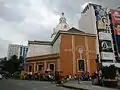 Santa Cruz Church
 San Roque Church
 Bethel Knox United Methodist Church
Civic institutions


Commercial establishments
 Chinatown (Plaza Santa Cruz), Third Welcome Gate (Arch of Goodwill) to Ongpin Street towards Binondo
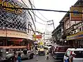 Ongpin Commercial Center
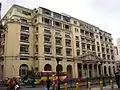 Bank of the Philippine Islands at Don Román Santos Building, a neo-classical, Graeco-Roman structure at Plaza Goiti (now Plaza Lacson)
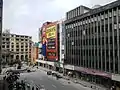 Carriedo Street with Plaza Lacson in the background
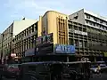 Commercial Buildings in Rizal Avenue
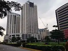 San Lazaro Tourism and Business Park (formerly the San Lázaro Racetrack)
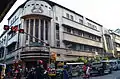 Capitan Pepe Building
Residences
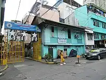
 Bahay na bato house in Santa Cruz, Manila
 Bahay na bato apartments in Santa Cruz, Manila
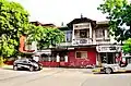 Period architecture in Santa Cruz, Manila
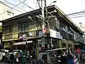 Bahay na Bato House in Bambang Rizal Avenue
See also
References
- "2020 Census of Population and Housing Results" (PDF). Philippine Statistics Authority. August 16, 2021. Retrieved April 28, 2022.
- "1014 MANILA (STA. CRUZ NORTH) Zip Codes Philippines". brgy.info. Retrieved March 26, 2021.
- "1003 manila Zip Codes Philippines". brgy.info. Retrieved March 26, 2021.
External links
 Media related to Santa Cruz, Manila at Wikimedia Commons
 Santa Cruz, Manila travel guide from Wikivoyage
- https://brgy.info/zipcodes/1014_manila.php
- https://brgy.info/zipcodes/1003_manila.php
| Topics |  | |
|---|---|---|
| Government |
| |
| Districts | ||
| Mixed-use developments |
| |
| Beaches | ||
| Legislative districts | ||
| ||