Borough of Stockton-on-Tees
The Borough of Stockton-on-Tees is a unitary authority with borough status in the counties of County Durham and North Yorkshire, England. The borough had a population of 191,600 in 2011.[1]
Borough of Stockton-on-Tees
Stockton Borough • Stockton | |
|---|---|
 Coat of arms | |
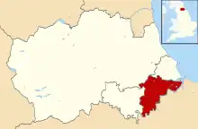 The part of the borough in County Durham | |
.svg.png.webp) The part of the borough in North Yorkshire | |
| Sovereign state | United Kingdom |
| Country | England |
| Region | North East England |
| Combined authority | Tees Valley |
| Ceremonial county | Durham North Yorkshire |
| Admin. HQ | Stockton-on-Tees |
| Government | |
| • Type | Stockton-on-Tees Borough Council |
| • Leadership: | Leader & Cabinet |
| • Executive: | Labour |
| • Tees Valley Mayor | Ben Houchen |
| • Mayor | Councillor Ross Patterson |
| • MPs: | Alex Cunningham (L) Matt Vickers (C) |
| Area | |
| • Total | 79.1 sq mi (204.9 km2) |
| • Rank | 143rd |
| Population (2021) | |
| • Total | 197,030 |
| • Rank | Ranked 98th |
| • Density | 2,500/sq mi (960/km2) |
| Time zone | UTC+0 (Greenwich Mean Time) |
| • Summer (DST) | UTC+1 (British Summer Time) |
| ONS code | 00EF (ONS) E06000004 (GSS) |
| Ethnicity | 97.2% White 1.7% S.Asian |
| Website | stockton.gov.uk |
The main settlement and namesake of the borough is Stockton-on-Tees, which lies on the north bank of the River Tees with the towns of Billingham and Norton-on-Tees. All three towns are in County Durham. The towns of Ingleby Barwick, Thornaby-on-Tees and Yarm are south of the river in North Yorkshire.
The borough governed by Stockton-on-Tees Borough Council, and the current mayor is Cllr Ross Patterson.[2] The borough is part of Tees Valley with nearby boroughs of Darlington, Middlesbrough, Redcar and Cleveland and Hartlepool.
All River Tees bridges from Yarm Viaduct to Transporter Bridge are in the borough at least on one side, with the Borough of Middlesbrough to the south downstream on the other side to the east of the borough. Teesside International Airport is shared between the borough and the Borough of Darlington.
History
Municipal authority
Stockton previously held borough status as the Municipal Borough of Stockton-on-Tees in historic County Durham.
Loss of status
In 1968, the borough was merged into Teesside County Borough; this civil parish was a part of the ceremonial (not administrative) North Riding county until its abolition.
District authority
The town regained borough status on 1 April 1974 as a result of the Local Government Act 1972. It became a non-metropolitan district of the County of Cleveland, itself established at the same time. Multiple parishes and boroughs merged into Stockton's newly formed district borough:
- Teesside County Borough's area covering the former Stockton, Billingham and Thornaby municipal boroughs,
- Hilton, Ingleby Barwick, Kirklevington, Maltby, and Yarm parishes of the previous North Riding County-administered Stokesley Rural District, and
- Part of the County Durham-administered Stockton Rural District parishes.
Unitary authority
The borough became a unitary authority on 1 April 1996. It is ceremonially split between County Durham and North Yorkshire, to the north and south of the Tees respectively. It is the only council in England to be split between two ceremonial counties. The former districts and boroughs of Durham now form the unitary authority of County Durham, so ceremonial County Durham now has four unitary authorities.
Council
The Borough has 26 wards with either one, two or three councillors representing each. There are 56 councillors in total. Following the 2019 elections, the councillors are divided politically as follows:
- 24 Labour
- 14 Conservative
and several smaller groups.
Economy
The Office for National Statistics has published a chart (pp. 240–253) of the trend of regional gross value of Hartlepool and Stockton-on-Tees (figures in Sterling [millions]).
| Year | Regional Gross Value Added4 | Agriculture1 | Industry2 | Services3 |
|---|---|---|---|---|
| 1995 | 2,804 | 9 | 1,443 | 1,352 |
| 2000 | 3,252 | 6 | 1,359 | 1,887 |
| 2003 | 3,364 | 6 | 1,037 | 2,320 |
^1 includes hunting and forestry.
^2 includes energy and construction.
^3 includes financial intermediation services indirectly measured.
^4 Components may not sum to totals due to rounding.
Demographics
In the 2021 census, the borough was recorded as having a population of 196,595 with 50.9% being female.
For religion, 51.1% identified themselves as Christian, 39.1% having no religion, 3.4% Muslim, 0.4% Hindu, 0.4% Sikh, 0.3% Buddhist, and 0.3% answering 'Other' as well as 5% not answering. [3]
For ethnicity, those who identified as White were 92.0%, Asian, Asian British or Asian Welsh were 4.6%, Black, Black British, Black Welsh, Caribbean or African were 1.1%, Mixed or Multiple ethnic groups were 1.4%, and the 'Other' ethnic group category recorded 0.8%.[3]
For sexuality, those who identified as Straight or Heterosexual were 91.6%, Gay or Lesbian were 1.4%, Bisexual was 0.9%, Pansexual was 0.2%, Asexual was 0.0%, Queer was 0.0, 'All other sexual orientations' were 0.0% and those who did not answer were 5.9%. [3]
[Note, for percentages with 0.0%, this may due to a number too low to represent using the number of digits supplied rather than a lack of those who identified as that specific idea]
| Sex | ||
|---|---|---|
| 2021 Census[3] | Count | % |
| All usual residents | 196,595 | 100.0 |
| Female | 100,072 | 50.9 |
| Male | 96,523 | 49.1 |
| Ethnicity | ||
|---|---|---|
| 2021 Census[3] | count | % |
| All usual residents | 196,593 | 100.0 |
| Asian, Asian British or Asian Welsh | 9,052 | 4.6 |
| Black, Black British, Black Welsh, Caribbean or African | 2,203 | 1.1 |
| Mixed or Multiple ethnic groups | 2,737 | 1.4 |
| White | 180,937 | 92.0 |
| Other ethnic group | 1,664 | 0.8 |
| Religion | ||
|---|---|---|
| 2021 Census[3] | count | % |
| All usual residents | 196,595 | 100.0 |
| No religion | 76,840 | 39.1 |
| Christian | 100,420 | 51.1 |
| Buddhist | 532 | 0.3 |
| Hindu | 811 | 0.4 |
| Jewish | 61 | 0.0 |
| Muslim | 6,675 | 3.4 |
| Sikh | 782 | 0.4 |
| Other religion | 550 | 0.3 |
| Not answered | 9,924 | 5.0 |
Local Nature Reserves
The council maintains a number of local nature reserves including Barwick Pond, Charlton's Pond, Greenvale, Hardwick Dene and Elm Tree Woods, Norton Grange Marsh, Quarry Wood (Eaglescliffe), and Stillington Forest Park.
References
- "Table P07 2011 Census: Number of usual residents living in households and communal establishments, local authorities in England and Wales". 2011 Census, Population and Household Estimates for England and Wales. Office for National Statistics. Retrieved 17 July 2012.
- "Meet the new Mayor of Stockton-on-Tees". Stockton-on-Tees Borough Council. Retrieved 26 May 2022.
- "Stockton-on-Tees Local Authority - 2021 Census Area Profile". NOMIS - official census and labour market statistics - National Statistics. 2021. Retrieved 31 January 2023.
External links
- Statistics about Stockton-on-Tees from the Office for National Statistics Census 2001
The borough of Stockton-on-Tees | |||||||
|---|---|---|---|---|---|---|---|
| Major Settlements | |||||||
| Villages | |||||||
| Governance |
| ||||||
| Culture, leisure and tourism | |||||||
| Services |
| ||||||
| Organisations |
| ||||||
| Sport | |||||||
| Waterways | |||||||
| Transport |
| ||||||
| Historic | |||||||
| Other |
| ||||||
| Unitary authorities | |
|---|---|
| Major settlements (cities in italics) |
|
| Topics | |

