Třebotov
Třebotov is a municipality and village in Prague-West District in the Central Bohemian Region of the Czech Republic. It has about 1,500 inhabitants.
Třebotov | |
|---|---|
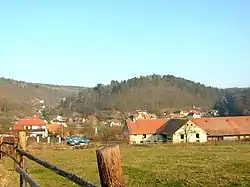 Solopisky, a part of Třebotov | |
 Flag  Coat of arms | |
 Třebotov Location in the Czech Republic | |
| Coordinates: 49°58′21″N 14°17′29″E | |
| Country | |
| Region | Central Bohemian |
| District | Prague-West |
| First mentioned | 1253 |
| Area | |
| • Total | 6.89 km2 (2.66 sq mi) |
| Elevation | 350 m (1,150 ft) |
| Population (2023-01-01)[1] | |
| • Total | 1,500 |
| • Density | 220/km2 (560/sq mi) |
| Time zone | UTC+1 (CET) |
| • Summer (DST) | UTC+2 (CEST) |
| Postal codes | 252 26, 252 28 |
| Website | www |
Administrative parts
Villages of Kala and Solopisky are administrative parts of Třebotov.
Geography
Třebotov is located about 9 km (6 mi) southwest of Prague. It lies in the Prague Plateau. The highest point is the hill Kulivá hora at 390 m (1,280 ft) above sea level. The entire municipality lies in the Bohemian Karst Protected Landscape Area.
History
The first written mention of Třebotov is in a deed of King Wenceslaus I from 1253.[2]
Sights
The landmark of Třebotov is the Church of Saint Martin. The original church was first mentioned in 1352 and probably dated from around 1300. Due to poor condition and architectural worthlessness, it was demolished. The current pseudo-Romanesque church was built on its site in 1867.[3]
Notable people
- Hana Růžičková (1941–1981), gymnast, Olympic medalist
References
- "Population of Municipalities – 1 January 2023". Czech Statistical Office. 2023-05-23.
- "Zpravodaj OÚ Třebotov 1/2017" (in Czech). Obec Třebotov. p. 1. Retrieved 2023-04-02.
- "Kostel sv. Jiří" (in Czech). Noc kostelů. Retrieved 2023-04-02.