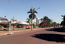
Tangará da Serra
Tangará da Serra is a municipality in the state of Mato Grosso in the Central-West Region of Brazil.[1][2][3][4]
Tangará da Serra | |
|---|---|
Municipality | |
 | |
 Flag  Seal | |
 | |
| Country | |
| Region | Southeast |
| State | Mato Grosso |
| Mesoregion | MidWest Mato-Grossense |
| Elevation | 1,388 ft (423 m) |
| Population (2020 est.[5]) | |
| • Total | 105,711 |
| Time zone | UTC−3 (BRT) |

Salto das Nuvens waterfalls in Tangará da Serra, Mato Grosso
The Sepotuba River, known for its many waterfalls and rapids, is located near Tangará da Serra.
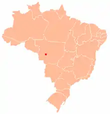
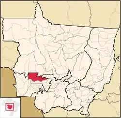
Location of Tangará da Serra
The city is served by Tangará da Serra Airport.
References
- "Divisão Territorial do Brasil" (in Portuguese). Divisão Territorial do Brasil e Limites Territoriais, Instituto Brasileiro de Geografia e Estatística (IBGE). July 1, 2008. Retrieved December 17, 2009.
- "Estimativas da população para 1º de julho de 2009" (PDF) (in Portuguese). Estimativas de População, Instituto Brasileiro de Geografia e Estatística (IBGE). August 14, 2009. Retrieved December 17, 2009.
- "Ranking decrescente do IDH-M dos municípios do Brasil" (in Portuguese). Atlas do Desenvolvimento Humano, Programa das Nações Unidas para o Desenvolvimento (PNUD). 2000. Retrieved December 17, 2009.
- "Produto Interno Bruto dos Municípios 2002-2005" (PDF) (in Portuguese). Instituto Brasileiro de Geografia e Estatística (IBGE). December 19, 2007. Retrieved December 17, 2009.
- IBGE 2020
Capital: Cuiabá | |||||||||||||||||
| Centro-Sul Mato-Grossense |
|  | |||||||||||||||
| Nordeste Mato-Grossense |
| ||||||||||||||||
| Norte Mato-Grossense |
| ||||||||||||||||
| Sudeste Mato-Grossense |
| ||||||||||||||||
| Sudoeste Mato-Grossense |
| ||||||||||||||||
This article is issued from Wikipedia. The text is licensed under Creative Commons - Attribution - Sharealike. Additional terms may apply for the media files.