Tarauacá
Tarauacá | |
|---|---|
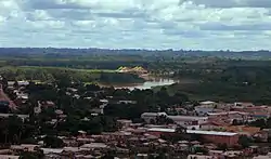
 Panoramic view of Downtown Tarauacá and Tarauacá River, Acre | |
 Seal | |
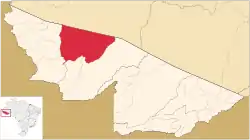
 Location of municipality in Acre State | |
 Tarauacá Location in Brazil | |
| Coordinates: 08°09′39″S 70°45′57″W | |
| Country | |
| Region | North |
| State | |
| Demonym | tarauacaense |
| Founded | January 1, 1907 |
| Government | |
| • Mayor | Marilete Vitorino (PSD) |
| Area | |
| • Total | 6,005.213 sq mi (15,553.430 km2) |
| Elevation | 551 ft (168 m) |
| Population (2020 est [1]) | |
| • Total | 43,151 |
| • Density | 4.6/sq mi (1.76/km2) |
| Time zone | UTC−5 (ACT) |
| Postal code | 69970 |
| Area code | +55 (68) |
Tarauacá (Portuguese pronunciation: [taɾɐwaˈka]) is a municipality located in the northwest of the Brazilian state of Acre. Tarauacá has a population of 43,151 people[2] and has an area 20,171 square kilometers (7,788 sq mi).[2]
Geography
The municipality contains 38% of the Alto Tarauacá Extractive Reserve, created in 2000.[3] It contains the 216,062 hectares (533,900 acres) Rio Gregório State Forest, a sustainable use conservation unit created in 2004.[4] It also contains the 143,897 hectares (355,580 acres) Mogno State Forest and the 126,360 hectares (312,200 acres) Rio Liberdade State Forest, two other sustainable use units created on the same date.[5][6]
Climate
| Climate data for Tarauaca, Acre, Brazil (1981–2010, extremes 1969–present) | |||||||||||||
|---|---|---|---|---|---|---|---|---|---|---|---|---|---|
| Month | Jan | Feb | Mar | Apr | May | Jun | Jul | Aug | Sep | Oct | Nov | Dec | Year |
| Record high °C (°F) | 36.0 (96.8) |
35.9 (96.6) |
35.7 (96.3) |
36.6 (97.9) |
34.8 (94.6) |
35.2 (95.4) |
38.1 (100.6) |
37.2 (99.0) |
39.7 (103.5) |
37.9 (100.2) |
36.5 (97.7) |
36.5 (97.7) |
39.7 (103.5) |
| Average high °C (°F) | 31.1 (88.0) |
31.1 (88.0) |
31.3 (88.3) |
31.5 (88.7) |
30.9 (87.6) |
30.8 (87.4) |
31.8 (89.2) |
32.9 (91.2) |
33.2 (91.8) |
32.6 (90.7) |
31.8 (89.2) |
31.3 (88.3) |
31.7 (89.1) |
| Daily mean °C (°F) | 25.8 (78.4) |
25.9 (78.6) |
26.0 (78.8) |
25.8 (78.4) |
25.2 (77.4) |
24.7 (76.5) |
24.6 (76.3) |
25.5 (77.9) |
26.0 (78.8) |
26.4 (79.5) |
26.1 (79.0) |
25.9 (78.6) |
25.7 (78.3) |
| Average low °C (°F) | 22.5 (72.5) |
22.4 (72.3) |
22.5 (72.5) |
22.2 (72.0) |
21.2 (70.2) |
20.0 (68.0) |
19.1 (66.4) |
19.5 (67.1) |
20.8 (69.4) |
22.0 (71.6) |
22.2 (72.0) |
22.5 (72.5) |
21.4 (70.5) |
| Record low °C (°F) | 11.8 (53.2) |
17.2 (63.0) |
16.6 (61.9) |
14.0 (57.2) |
13.5 (56.3) |
10.2 (50.4) |
6.5 (43.7) |
9.7 (49.5) |
10.0 (50.0) |
2.2 (36.0) |
2.4 (36.3) |
17.8 (64.0) |
2.2 (36.0) |
| Average precipitation mm (inches) | 281.7 (11.09) |
257.6 (10.14) |
326.8 (12.87) |
200.9 (7.91) |
135.9 (5.35) |
60.9 (2.40) |
48.7 (1.92) |
62.5 (2.46) |
112.0 (4.41) |
193.1 (7.60) |
262.3 (10.33) |
270.5 (10.65) |
2,212.9 (87.12) |
| Average precipitation days (≥ 1.0 mm) | 19 | 17 | 19 | 15 | 13 | 7 | 5 | 6 | 8 | 14 | 15 | 19 | 157 |
| Average relative humidity (%) | 87.1 | 87.5 | 88.0 | 86.7 | 86.2 | 85.5 | 82.4 | 80.0 | 80.4 | 83.7 | 86.1 | 87.0 | 85.1 |
| Mean monthly sunshine hours | 104.2 | 87.3 | 96.9 | 122.6 | 141.8 | 155.5 | 204.6 | 187.0 | 163.3 | 159.2 | 129.1 | 104.7 | 1,656.2 |
| Source 1: Instituto Nacional de Meteorologia[7] | |||||||||||||
| Source 2: Meteo Climat (record highs and lows)[8] | |||||||||||||
Economy
In 2017, Tarauacá had per capita GDP of 11.763,89 R$, total revenue of 71.657.950 R$, and total expenses of 63.519.410 R$.[1]
Transportation
Tarauacá is served by José Galera dos Santos Airport. It is a small airport.
References
- "Panorama". cidades.ibge.gov.br (in Brazilian Portuguese). Brazilian Institute of Geography and Statistics. Archived from the original on September 1, 2018. Retrieved 20 April 2023.
- ibge.gov.br
- RESEX do Alto Tarauacá (in Portuguese), ISA: Instituto Socioambiental, retrieved 2016-08-07
- FES do Rio Gregório (in Portuguese), ISA: Instituto Socioambiental, retrieved 2016-07-01
- FES do Mogno (in Portuguese), ISA:Instituto Socoambiental, retrieved 2016-07-01
- FES do Rio Liberdade (in Portuguese), ISA: Instituto Sociambiental, retrieved 2016-07-01
- "Normais Climatológicas Do Brasil 1981–2010" (in Portuguese). Instituto Nacional de Meteorologia. Retrieved 20 October 2018.
- "Station Tarauaca" (in French). Meteo Climat. Retrieved 20 October 2018.
