Tardets-Sorholus
Tardets-Sorholus (French pronunciation: [taʁdɛts sɔʁɔlys]; Basque: Atharratze-Sorholüze)[3] is a commune in the Pyrénées-Atlantiques department in south-western France.
Tardets-Sorholus
Atharratze-Sorholüze | |
|---|---|
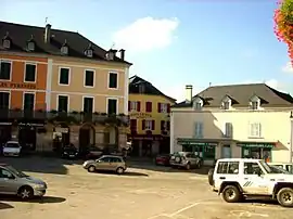 The central square of the village | |
 Coat of arms | |
Location of Tardets-Sorholus | |
 Tardets-Sorholus  Tardets-Sorholus | |
| Coordinates: 43°07′03″N 0°51′41″W | |
| Country | France |
| Region | Nouvelle-Aquitaine |
| Department | Pyrénées-Atlantiques |
| Arrondissement | Oloron-Sainte-Marie |
| Canton | Montagne Basque |
| Intercommunality | CA Pays Basque |
| Government | |
| • Mayor (2020–2026) | Maïté Pitrau[1] |
| Area 1 | 14.99 km2 (5.79 sq mi) |
| Population | 566 |
| • Density | 38/km2 (98/sq mi) |
| Time zone | UTC+01:00 (CET) |
| • Summer (DST) | UTC+02:00 (CEST) |
| INSEE/Postal code | 64533 /64470 |
| Elevation | 209–793 m (686–2,602 ft) (avg. 298 m or 978 ft) |
| 1 French Land Register data, which excludes lakes, ponds, glaciers > 1 km2 (0.386 sq mi or 247 acres) and river estuaries. | |
It is located in the former province of Soule.[3]
_-_Fonds_Ancely_-_B315556101_A_MALBOS_2_011.jpg.webp)
Tardets Valey in 1843 by Eugène de Malbos.
References
- "Répertoire national des élus: les maires" (in French). data.gouv.fr, Plateforme ouverte des données publiques françaises. 13 September 2022.
- "Populations légales 2020". The National Institute of Statistics and Economic Studies. 29 December 2022.
- ATHARRATZE-SORHOLÜZE, Auñamendi Eusko Entziklopedia (in Spanish)
Wikimedia Commons has media related to Tardets-Sorholus.
This article is issued from Wikipedia. The text is licensed under Creative Commons - Attribution - Sharealike. Additional terms may apply for the media files.