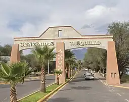
Tasquillo
Tasquillo (Otomi: Maxei) is a town and one of the 84 municipalities of Hidalgo, in central-eastern Mexico. it is located km 5 from the Mexican Federal Highway 45 and km 10 from the nearby city of Ixmiquilpan in the central west part of the state of Hidalgo.
Tasquillo
Maxei | |
|---|---|
Municipality and Town | |
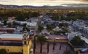 Tasqullio seen from an aerial view with the Parroquia San Bernardino de Siena seen on the left | |
 Seal | |
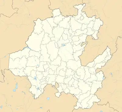 Tasquillo Location in Mexico 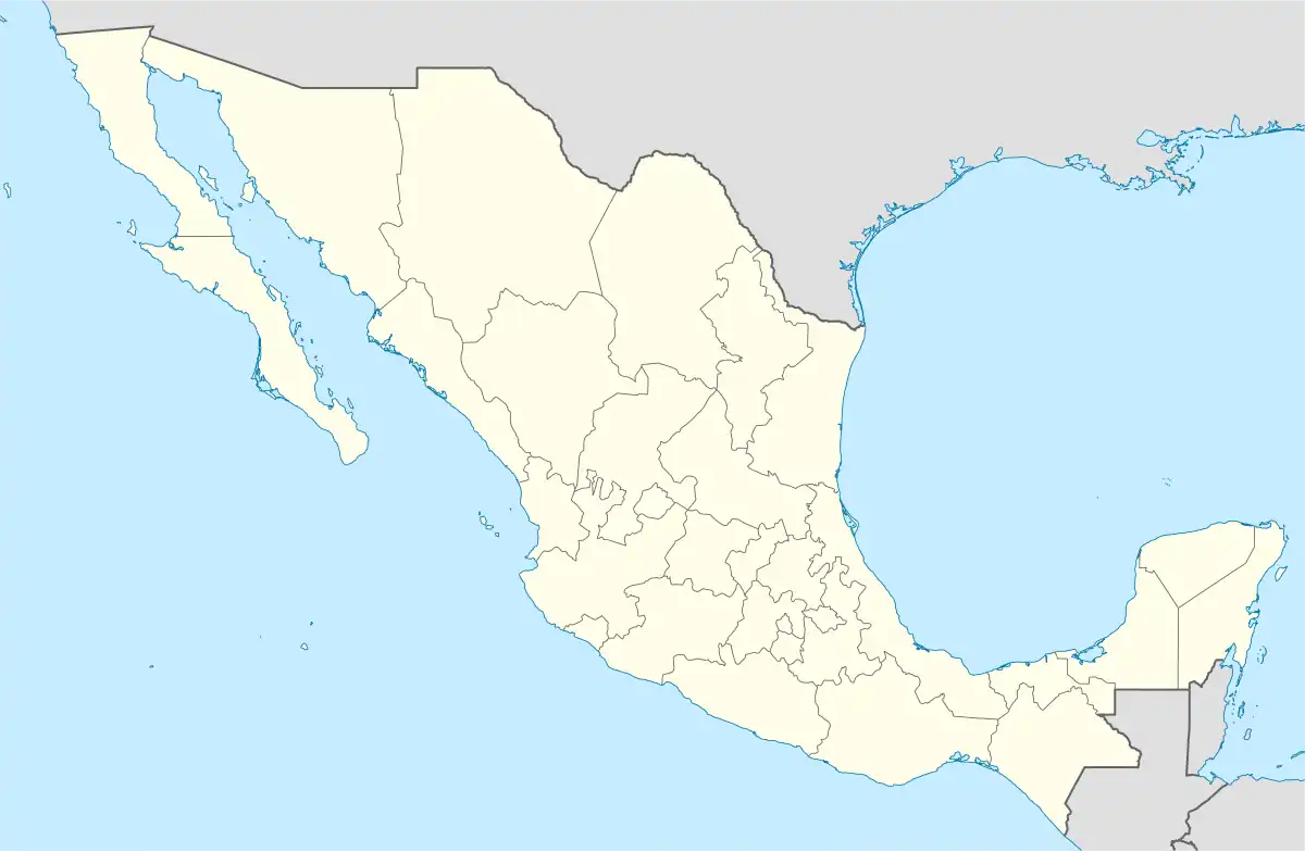 Tasquillo Tasquillo (Mexico) | |
| Coordinates: 20°37′N 99°15′W | |
| Country | |
| State | Hidalgo |
| Municipality | Tasquillo |
| Government | |
| • Municipal President | Humberto Fuentes Portillo (2023-) |
| Area | |
| • Municipality and Town | 240 km2 (90 sq mi) |
| Elevation | 1,631 m (5,351 ft) |
| Population (2020) | |
| • Municipality and Town | 17,451 |
| • Density | 72/km2 (190/sq mi) |
| • Rural | 13,421 |
| Demonym(s) | Tasquillense Taquillano |
| Time zone | Central (US Central) |
It has not been possible to clarify whether the word Tasquillo is of origin Otomí or Nahuatl.[1]
History
Pre-Hispanic Period
Tasquillo was populated by a few ethnic groups which were the Nahuas, Toltecs and especially the Otomí groups who have given the name “Mashei ” to the place.[2]
Among the most important historical events are the discoveries of curious junk, metals, carved stones or sticks and tools of men who were buried in clay pots. It is said that that these relics are found in the Huemac.[1]
15th - Early 20th Century
in the 15th century under the domination of the Mexica culture it was named Taxco. Later, with the Spanish conquest in the 16th century, it was given the name “town of the natives of San Bernardino,” subject to a commission from the Marquis of Zúñiga. [2] and during this time the Spaniards settled at a point called Donijá, which is located southeast of the main square.[3]
in the 17th century it was given the name of Taxquillo, a word composed from Nahuatl, in Nahuatl the word comes from the game of tlachtli which means "ball game", In it's Otomi dialect the meaning would be "Place of Goats", in Spanish the word of illo means diminutive or small, which gives it another meaning "Small place of the game of ball" or "Small place of goats".[2][4][1]
According to what is known by the mayoralties, in the 18th century it was not considered among the towns to citizens due to its lack of importance and poverty-rate, since it was simply a neighborhood and municipal seat of the town-hall of Ixmiquilpan.[5][3][1]
1820s-1920s
The constitution of the municipality of Tasquillo [3] is achieved as a town hall belonging to the Huichapan district of the Tula prefecture on the 15th of February 1826.
in 1861 to 1869, Tasquillo is recorded as a municipality forming part from the Zimapán district of the State of Mexico and eventually becoming a municipality of the Ixmiquilpan district belonging to the Tula department of the State of Mexico. Once the State of Hidalgo was established in 1869, Tasqullio was designated as the head of the Municipality of its name for the Zimapan District, And until 1920 Tasquillo was recorded as a free municipality.[1]
Geography

It is located in the geographic region of the Mezquital Valley, specifically located below the peak called Cerro Juarez.
Climate
| Climate data for Tasquillo | |||||||||||||
|---|---|---|---|---|---|---|---|---|---|---|---|---|---|
| Month | Jan | Feb | Mar | Apr | May | Jun | Jul | Aug | Sep | Oct | Nov | Dec | Year |
| Record high °C (°F) | 35.0 (95.0) |
34.0 (93.2) |
37.0 (98.6) |
38.0 (100.4) |
37.0 (98.6) |
37.0 (98.6) |
35.0 (95.0) |
35.0 (95.0) |
34.0 (93.2) |
32.0 (89.6) |
34.0 (93.2) |
34.0 (93.2) |
38.0 (100.4) |
| Average high °C (°F) | 25.7 (78.3) |
26.7 (80.1) |
28.3 (82.9) |
29.5 (85.1) |
30.4 (86.7) |
29.6 (85.3) |
28.9 (84.0) |
28.9 (84.0) |
28 (82) |
27.2 (81.0) |
26.3 (79.3) |
25.7 (78.3) |
27.9 (82.2) |
| Daily mean °C (°F) | 15.9 (60.6) |
16.8 (62.2) |
18.7 (65.7) |
19.9 (67.8) |
20.9 (69.6) |
20.6 (69.1) |
20.2 (68.4) |
20.1 (68.2) |
19.4 (66.9) |
18.5 (65.3) |
17.1 (62.8) |
16.2 (61.2) |
18.7 (65.7) |
| Average low °C (°F) | 6.1 (43.0) |
7.1 (44.8) |
9.1 (48.4) |
10.4 (50.7) |
11.3 (52.3) |
11.7 (53.1) |
11.5 (52.7) |
11.3 (52.3) |
10.9 (51.6) |
9.7 (49.5) |
7.9 (46.2) |
6.6 (43.9) |
9.5 (49.1) |
| Record low °C (°F) | 0 (32) |
1 (34) |
3 (37) |
5 (41) |
1 (34) |
4 (39) |
7 (45) |
7 (45) |
7 (45) |
2 (36) |
0 (32) |
0 (32) |
0 (32) |
| Average precipitation mm (inches) | 6.9 (0.27) |
8.5 (0.33) |
11 (0.4) |
13 (0.5) |
29.4 (1.16) |
52.4 (2.06) |
59.4 (2.34) |
43.4 (1.71) |
53.4 (2.10) |
36 (1.4) |
8.1 (0.32) |
2.5 (0.10) |
324 (12.8) |
| Average precipitation days (≥ 0.1 mm) | 1.1 | 0.9 | 1.2 | 1.5 | 3.3 | 4.8 | 4.4 | 3.4 | 4 | 3.3 | 1 | 0.4 | 29.3 |
| Source: Servicio Meteorologico Nacional[7] | |||||||||||||
The Town
Tasqullio covers an area of 167 km² with the town having a population of only 4,030 as of 2020.[8]
Parroquia San Bernardino de Siena
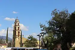
The Parroquia of San Bernardino de Siena is located in the town. Which was founded in 1560 and dedicated to the Italian saint Bernardino of Siena. The church has baroque style architecture and is located in the center of the city. The parish is known for its annual festival in honor of San Bernardino of Siena, which is celebrated on May 20.[9]
Municipality
The Municipality itself has an area of 240.01 km within the Mezquital Valley with the municipality having a total population of 17,451 as of 2020.[10] It borders with the municipalities of Tecozautla, Zimapán, Ixmiquilpan, Alfajayucan, Alfajayucan and Tecozautla.
Demographics
| Year | Pop. | ±% |
|---|---|---|
| 1900 | 874 | — |
| 1967 | 10,245 | +1072.2% |
| 1995 | 16,926 | +65.2% |
| 2000 | 16,648 | −1.6% |
| 2005 | 15,429 | −7.3% |
| 2010 | 16,865 | +9.3% |
| 2020 | 17,451 | +3.5% |
Municipal Presidents
• Felipe Hernández J. 1964-1967
• Rosalio Arteaga Hernández 1967–1970
• Francisco Fuentes Olguín 1970–1973
• Jesús Torres Guerrero 1973-1976
• J. Carmen Hdz Medina 1976-1979
• J. Carmen Hdz Medina 1979-1982
• Pablo Torres Cruz 1982-1985
• Enrique Ocampo S. 1985-1988
• Abel Rojo Muñoz 1988-1991
• Maurilio Martínez S. Juan 1991–1994
• Pascual Basilio Basilio 1994-1997
• Fausto Trejo Hernández 1997-2000
• Jaime Cruz Vázquez 2000-2003
• Eulogio Resendiz Resendiz 2003-2006
• Gonzalo Callejas Ureña 2006-2009
• Arturo Ramírez Mendoza 2009-2012
• Alberto Sánchez González 2012-2016
• Miriam Ramirez Mendoza 2016-2020
• María de Jesús Chávez 2020-2021
• María Isabel Guerrero Trejo 2021-2023
• Humberto Fuentes Portillo 2023-
References
- http://docencia.uaeh.edu.mx/estudios-pertinencia/docs/hidalgo-municipios/Tasquillo-Enciclopedia-De-Los-Municipios.pdf
- "Historia". tasquillo.gob.mx. Retrieved 2023-10-25.
- "Tasquillo Hidalgo". Hidalgo Tierra Mágica (in European Spanish). Retrieved 2023-10-25.
- Andrews, Enriqueta (1950). Vocabulario otomí [de Tasquillo, Hidalgo]: primera parte, Otomí-Español ; segunda parte, Español-Otomí (in Spanish). Instituto Lingüístico de Verano.
- http://web.uaemex.mx/identidad/docs/cronicas/2021/TOMO_XIX/6.Hernandez-Leal.pdf
- Montoya, Juan Ricardo (January 30, 2021). "La Jornada - Muere alcaldesa de Tasquillo, Hidalgo, por Covid-19". jornada.com.mx (in Spanish). La Jornada. Retrieved January 30, 2021.
- 1991-1990, National Meteorological service of Mexico. Retrieved 27 October 2023 .
- "Tasquillo (Hidalgo) Tasquillo". mexico.PueblosAmerica.com. Retrieved 2023-10-24.
- marsito3 (2023-01-15). "Parroquia San Bernardino de Siena (Tasquillo)- Horario de misas y servicios". iglesiasymisas.com.mx (in Spanish). Retrieved 2023-10-26.
- "Tasquillo: Economy, employment, equity, quality of life, education, health and public safety". Data México. Retrieved 2023-08-18.