Tecozautla
Tecozautla (Otomi: Masofo) is a town and one of the 84 municipalities of Hidalgo, in central-eastern Mexico. The municipality covers an area of 575.6 km². The name derives from the Nahuatl words "tetl", meaning "stone"; "cozaqui", meaning "yellow thing"; and "tla", meaning "place of"; making the entire meaning of Tecozautla "place where yellow earth abounds".[1]
Tecozautla | |
|---|---|
Municipality and town | |
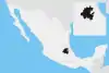
 Tecozautla Location in Mexico | |
| Coordinates: 20°32′N 99°38′W | |
| Country | |
| State | Hidalgo |
| Municipal seat | Tecozautla (municipality) |
| Area | |
| • Total | 575.6 km2 (222.2 sq mi) |
| Population (2005) | |
| • Total | 31,609 |
As of 2005, the municipality had a total population of 31,609.[2] In 2017 there were 2,415 inhabitants who spoke an indigenous language,[3] primarily Mezquital Otomi.[4] The town was declared a "Pueblo Mágico" in 2015.[1]
References
- Turismo, Secretaría de. "Tecozautla, Hidalgo". gob.mx (in Spanish). Retrieved 2021-05-25.
- "Tecozautla". Enciclopedia de los Municipios de México. Instituto Nacional para el Federalismo y el Desarrollo Municipal. Retrieved December 27, 2008.
- "Información Estadística Básica: Carpeta Municipal Tecozautla" (PDF). Sistema Integral de Información del Estado de Hidalgo. Secretaria de Planeación Desarrollo Regional Regional y Metropolitano. Archived from the original (PDF) on 30 December 2017. Retrieved 22 March 2017.
- Báez Cubero, Lourdes; Garret Ríos, Gabriela; Pérez González, David; Moreno Alcántara, Beatriz; Fierro Alonso, Ulises Julio; Hernández García, Milton Gabriel (2012). Instituto Nacional de Antropología e Historia (ed.). Los pueblos indígenas de Hidalgo: Atlas etnográfico (PDF) (Primera ed.). México, D.F; México. pp. 32–35. ISBN 978-607-484-357-6.
{{cite book}}: CS1 maint: location missing publisher (link)
This article is issued from Wikipedia. The text is licensed under Creative Commons - Attribution - Sharealike. Additional terms may apply for the media files.