Tennessee statistical areas

The U.S. State of Tennessee currently has 34 statistical areas that have been delineated by the Office of Management and Budget (OMB). On March 6, 2020, the OMB delineated seven combined statistical areas, ten metropolitan statistical areas, and 17 micropolitan statistical areas in Tennessee.[1]
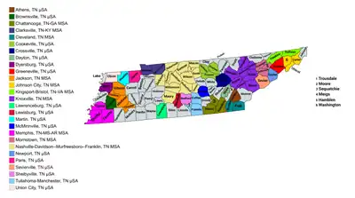
Map of the 27 core-based statistical areas in Tennessee.
An enlargeable map of the 27 core-based statistical areas in Tennessee.[1]

Statistical areas

The Office of Management and Budget (OMB) has designated more than 1,000 statistical areas for the United States and Puerto Rico.[2] These statistical areas are important geographic delineations of population clusters used by the OMB, the United States Census Bureau, planning organizations, and federal, state, and local government entities.

The OMB defines a core-based statistical area (commonly referred to as a CBSA) as "a statistical geographic entity consisting of the county or counties (or county-equivalents) associated with at least one core[lower-alpha 1] of at least 10,000 population, plus adjacent counties having a high degree of social and economic integration with the core as measured through commuting ties with the counties containing the core."[2] The OMB further divides core-based statistical areas into metropolitan statistical areas (MSAs) that have "a population of at least 50,000" and micropolitan statistical areas (μSAs) that have "a population of at least 10,000, but less than 50,000."[2]

The OMB defines a combined statistical area (CSA) as "a geographic entity consisting of two or more adjacent core-based statistical areas with employment interchange measures[lower-alpha 2] of at least 15%."[2] The primary statistical areas (PSAs) include all combined statistical areas and any core-based statistical area that is not a constituent of a combined statistical area.

Table

The table below describes the 34 United States statistical areas and 95 counties of the State of Tennessee with the following information:[3]

  1. The combined statistical area (CSA) as designated by the OMB.[1]
  2. The CSA population according to 2019 US Census Bureau population estimates.[4]
  3. The core based statistical area (CBSA)[2] as designated by the OMB.[1]
  4. The CBSA population according to 2019 US Census Bureau population estimates [4]
  5. The county name
  6. The county population according to 2019 US Census Bureau population estimates [4]
The 34 United States statistical areas and 95 counties of the State of Tennessee

Combined Statistical Area 2019 Population Core Based Statistical Area 2019 Population County 2019 Population
Nashville-Davidson-Murfreesboro, TN CSA 2,062,547 Nashville-Davidson-Murfreesboro-Franklin, TN MSA 1,934,317 Davidson County, Tennessee 694,144
Rutherford County, Tennessee 332,285
Williamson County, Tennessee 238,412
Sumner County, Tennessee 191,283
Wilson County, Tennessee 144,657
Maury County, Tennessee 96,387
Robertson County, Tennessee 71,813
Dickson County, Tennessee 53,948
Cheatham County, Tennessee 40,667
Macon County, Tennessee 24,602
Smith County, Tennessee 20,157
Cannon County, Tennessee 14,678
Trousdale County, Tennessee 11,284
Shelbyville, TN μSA 49,713 Bedford County, Tennessee 49,713
Lawrenceburg, TN μSA 44,142 Lawrence County, Tennessee 44,142
Lewisburg, TN μSA 34,375 Marshall County, Tennessee 34,375
Knoxville-Morristown-Sevierville, TN CSA 1,146,049 Knoxville, TN MSA 869,046 Knox County, Tennessee 470,313
Blount County, Tennessee 133,088
Anderson County, Tennessee 76,978
Loudon County, Tennessee 54,068
Roane County, Tennessee 53,382
Campbell County, Tennessee 39,842
Morgan County, Tennessee 21,403
Union County, Tennessee 19,972
Morristown, TN MSA 142,749 Hamblen County, Tennessee 64,934
Jefferson County, Tennessee 54,495
Grainger County, Tennessee 23,320
Sevierville, TN μSA 98,250 Sevier County, Tennessee 98,250
Newport, TN μSA 36,004 Cocke County, Tennessee 36,004
Memphis-Forrest City, TN-MS-AR CSA 1,371,039
1,039,898
Memphis, TN-MS-AR MSA 1,346,045
1,039,898
Shelby County, Tennessee 937,166
DeSoto County, Mississippi 184,945
Tipton County, Tennessee 61,599
Crittenden County, Arkansas 47,955
Fayette County, Tennessee 41,133
Marshall County, Mississippi 35,294
Tate County, Mississippi 28,321
Tunica County, Mississippi 9,632
Forrest City, AR μSA 25,439 St. Francis County, Arkansas 25,439
Chattanooga-Cleveland-Dalton, TN-GA CSA 1,004,573
623,640
Chattanooga, TN-GA MSA 565,194
411,737
Hamilton County, Tennessee 367,804
Walker County, Georgia 69,761
Catoosa County, Georgia 67,580
Marion County, Tennessee 28,907
Dade County, Georgia 16,116
Sequatchie County, Tennessee 15,026
Dalton, GA MSA 144,724 Whitfield County, Georgia 104,628
Murray County, Georgia 40,096
Cleveland, TN MSA 124,942 Bradley County, Tennessee 108,110
Polk County, Tennessee 16,832
Calhoun, GA μSA 57,963 Gordon County, Georgia 57,963
Athens, TN μSA 53,794 McMinn County, Tennessee 53,794
Dayton, TN μSA 33,167 Rhea County, Tennessee 33,167
Summerville, GA μSA 24,789 Chattooga County, Georgia 24,789
Johnson City-Kingsport-Bristol, TN-VA CSA 510,990
418,922
Kingsport-Bristol, TN-VA MSA 306,946
214,878
Sullivan County, Tennessee 158,348
Hawkins County, Tennessee 56,530
Washington County, Virginia 53,740
Scott County, Virginia 21,566
City of Bristol, Virginia 16,762
Johnson City, TN MSA 204,044 Washington County, Tennessee 129,375
Carter County, Tennessee 56,786
Unicoi County, Tennessee 17,883
none Clarksville, TN-KY MSA 307,820
222,708
Montgomery County, Tennessee 208,993
Christian County, Kentucky 70,461
Trigg County, Kentucky 14,651
Stewart County, Tennessee 13,715
Jackson-Brownsville, TN CSA 195,948 Jackson, TN MSA 178,644 Madison County, Tennessee 97,984
Gibson County, Tennessee 49,133
Chester County, Tennessee 17,297
Crockett County, Tennessee 14,230
Brownsville, TN μSA 17,304 Haywood County, Tennessee 17,304
none Cookeville, TN μSA 114,272 Putnam County, Tennessee 80,245
Overton County, Tennessee 22,241
Jackson County, Tennessee 11,786
Tullahoma-Manchester, TN μSA 105,216 Coffee County, Tennessee 56,520
Franklin County, Tennessee 42,208
Moore County, Tennessee 6,488
Greeneville, TN μSA 69,069 Greene County, Tennessee 69,069
Martin-Union City, TN CSA 63,397 Martin, TN μSA 33,328 Weakley County, Tennessee 33,328
Union City, TN μSA 30,069 Obion County, Tennessee 30,069
none Crossville, TN μSA 60,520 Cumberland County, Tennessee 60,520
McMinnville, TN μSA 41,277 Warren County, Tennessee 41,277
Dyersburg, TN μSA 37,159 Dyer County, Tennessee 37,159
Paris, TN μSA 32,345 Henry County, Tennessee 32,345
none Monroe County, Tennessee 46,545
Lincoln County, Tennessee 34,366
Claiborne County, Tennessee 31,959
Giles County, Tennessee 29,464
Henderson County, Tennessee 28,117
Carroll County, Tennessee 27,767
White County, Tennessee 27,345
McNairy County, Tennessee 25,694
Hardin County, Tennessee 25,652
Lauderdale County, Tennessee 25,633
Hardeman County, Tennessee 25,050
Scott County, Tennessee 22,068
DeKalb County, Tennessee 20,490
Humphreys County, Tennessee 18,582
Fentress County, Tennessee 18,523
Johnson County, Tennessee 17,788
Wayne County, Tennessee 16,673
Benton County, Tennessee 16,160
Bledsoe County, Tennessee 15,064
Grundy County, Tennessee 13,427
Meigs County, Tennessee 12,422
Lewis County, Tennessee 12,268
Decatur County, Tennessee 11,663
Houston County, Tennessee 8,201
Perry County, Tennessee 8,076
Clay County, Tennessee 7,615
Lake County, Tennessee 7,016
Hancock County, Tennessee 6,620
Van Buren County, Tennessee 5,872
Pickett County, Tennessee 5,048
State of Tennessee 6,829,313

See also

Notes

  1. The OMB defines a core as "a densely settled concentration of population, comprising an Urban Area (of 10,000 or more population) delineated by the Census Bureau, around which a core-based statistical area is delineated."[2]
  2. The OMB defines the employment interchange measure as "the sum of the percentage of workers living in the smaller entity who work in the larger entity plus the percentage of employment in the smaller entity that is accounted for by workers who reside in the larger entity."[2]

References

  1. Revised Delineations of Metropolitan Statistical Areas, Micropolitan Statistical Areas, and Combined Statistical Areas, and Guidance on Uses of the Delineations of These Areas (March 6, 2020). "0MB BULLETIN NO. 20-01" (PDF). Office of Management and Budget. Retrieved December 15, 2021.{{cite web}}: CS1 maint: multiple names: authors list (link)
  2. "2020 Standards for Delineating Core Based Statistical Areas". Office of Management and Budget. July 16, 2021. Retrieved December 15, 2021.
  3. An out-of-state area and its population are displayed in green. An area that extends into more than one state is displayed in teal. A teal population number over a black population number show the total population versus the in-state population.
  4. "Annual Estimates of the Resident Population for Counties in the United States: April 1, 2010 to July 1, 2019". United States Census Bureau, Population Division. April 2020. Retrieved April 9, 2020.

35.8580°N 86.3505°W / 35.8580; -86.3505 (State of Tennessee)

This article is issued from Wikipedia. The text is licensed under Creative Commons - Attribution - Sharealike. Additional terms may apply for the media files.