Trojanovice
Trojanovice is a municipality and village in Nový Jičín District in the Moravian-Silesian Region of the Czech Republic. It has about 2,800 inhabitants.
Trojanovice | |
|---|---|
.jpg.webp) Trojanovice seen from Radhošť | |
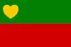 Flag 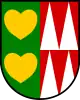 Coat of arms | |
 Trojanovice Location in the Czech Republic | |
| Coordinates: 49°31′13″N 18°14′17″E | |
| Country | |
| Region | Moravian-Silesian |
| District | Nový Jičín |
| Founded | 1748 |
| Area | |
| • Total | 35.85 km2 (13.84 sq mi) |
| Elevation | 500 m (1,600 ft) |
| Population (2023-01-01)[1] | |
| • Total | 2,786 |
| • Density | 78/km2 (200/sq mi) |
| Time zone | UTC+1 (CET) |
| • Summer (DST) | UTC+2 (CEST) |
| Postal code | 744 01 |
| Website | www |
Geography
Trojanovice is located about 18 kilometres (11 mi) southeast of Nový Jičín and 30 km (19 mi) south of Ostrava. It lies in the Moravian-Silesian Beskids mountain range. The highest point is the Radhošť mountain at 1,129 m (3,704 ft) above sea level, the summit of which lies on the southern municipal border. The Lomná River flows through the municipality.
History
The colonization of the area of Trojanovice by Vlachs began in the 16th century, when it belonged to Frenštát pod Radhoštěm. It was settled mostly by pastoralists. In 1748, it separated from Frenštát pod Radhoštěm as a self-governing municipality.[2]
Between 1850 and 1900, almost 500 inhabitants of Trojanovice moved abroad, especially to Texas; their descendants live in Fayetteville, Weimar, Hostyn, Dubina or nearby.[2][3]
Sport
The Pustevny Ski Resort is located in the southern part of the municipality. The cable car that leads to the Pustevny mountain saddle was built in 1940 and was the first of its kind in the world.[3]
Sights
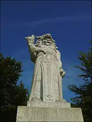
On the Radhošť mountain there are located the Chapel of Saints Cyril and Methodius, and the Radegast statue by Albin Polasek (the original from 1929 was replaced with a copy in 1998).[4]
The Velký Javorník mountain is one of the most visited tourist destination in the Moravian-Silesian Beskids. There is a 26 m (85 ft)-high wooden observation tower, a restaurant built in 1935, and a paragliding ramp.[5]
References
- "Population of Municipalities – 1 January 2023". Czech Statistical Office. 2023-05-23.
- "Historie obce" (in Czech). Obec Trojanovice. Retrieved 2022-02-23.
- "Historie obce Trojanovice" (in Czech). Lysá hora. Retrieved 2022-02-23.
- "Sochy stojí osmdesát pět let" (in Czech). Novojičínský deník. 2016-07-16. Retrieved 2022-02-23.
- "Velký Javorník v Beskydech – pohleďte z rozhledny na na vrcholy Beskyd" (in Czech). CzechTourism. Retrieved 2022-02-23.