Chafe, Nigeria
Tsafe (or Chafe) is a Local Government Area L G A) in Zamfara State, Nigeria. Its headquarters is in the town of Chafe at11°56′00″N 6°54′00″E. It has an area of 1,698 km2 and a population of 266,008 at the 2006 census. The postal code of the area is 880.[1]
Tsafe
Tsafe | |
|---|---|
LGA and town | |
 Tsafe Location in Nigeria | |
| Coordinates: 11°56′N 6°54′E | |
| Country | |
| State | Zamfara State |
| Area | |
| • Total | 1,698 km2 (656 sq mi) |
| Population (2006 census) | |
| • Total | 266,008 |
| Time zone | UTC+1 (WAT) |
| 3-digit postal code prefix | 880 |
| ISO 3166 code | NG.ZA.TS |
Climate
In Tsafe, the dry season is partially cloudy and hot all year round, while the wet season is oppressive and generally cloudy. The average annual temperature ranges from 56 to 99 degrees Fahrenheit, rarely falling below 51 or rising over 104.[2]
From March 7 to May 5, the hot season, with an average daily high temperature exceeding 96°F, lasts for 1.9 months. With an average high of 98°F and low of 72°F, April is the hottest month of the year in Tsafe.[3]
Between July 8 and October 1, which is the length of the chilly season, the daily high temperature typically falls below 87°F. With an average low of 57°F and high of 87°F, January is the coldest month of the year in Tsafe.[4]
References
- "Post Offices- with map of LGA". NIPOST. Archived from the original on 2009-10-07. Retrieved 2009-10-20.
- "Tsafe Climate, Weather By Month, Average Temperature (Nigeria) - Weather Spark". weatherspark.com. Retrieved 2023-09-29.
- "14 Day Weather Tsafe". meteoblue. Retrieved 2023-09-29.
- "Monthly climate in Tsafe, Zamfara, Nigeria". nomadseason.com. Retrieved 2023-09-29.
State capital: Gusau | ||
| Local Government Areas | 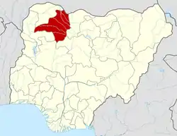 | |