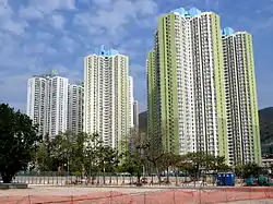
Un Chau Estate
Un Chau Estate (Chinese: 元州邨), or Un Chau Street Estate (Chinese: 元州街邨) before redevelopment, is a public housing estate on the reclaimed land of Cheung Sha Wan, Kowloon, Hong Kong, located between Un Chau Street and Cheung Sha Wan Road, next to MTR Cheung Sha Wan station.[1] It consists of 10 residential buildings completed in 1998, 1999 and 2008, which were developed into 4 phases. Phase 5 was developed on the site of the former Cheung Sha Wan Factory Estate.[2]

Background
Un Chau Street Estate had 8 residential blocks completed in 1969,[3] but all the blocks were demolished in 1990s and 2000s, and replaced by new-typed buildings. The redeveloped estate was renamed as "Un Chau Estate".[4] Phase 1 and 3 consists of 6 residential buildings (a building for senior citizens included) and a shopping centre, which were completed between 1998 and 1999.[5][6][7] Phase 2 and 4 consists of 5 residential buildings completed in 2008.[8][9]
Phase 5 is on the site of the former Cheung Sha Wan Factory Estate. It comprises three site-oriented domestic blocks and an ancillary facilities block providing car parks, amenity facilities, elderly centre and the integrated family services centre. Foundation works commenced in 2007 and was completed in 2012.[10]
Demographics
According to the 2016 population by-census, Un Chau Estate has a population of 18,482. 97% of the population is of Chinese ancestry. Median monthly domestic household income is HK$ 14,930.[11]
- Map of former Un Chau Street Estate
 Blocks of former Un Chau Street Estate in 1980s
 Blocks of former Un Chau Street Estate in 1990s
 Phase 1 Un Hong House, Un Chau Estate
 Phase 2, Un Chau Estate
 Phase 2 and 4, Un Chau Estate
 Phase 4 Un Kin House, Un Chau Estate
 Phase 5 in 2012
Houses
| Name | Chinese name | Type | Completion |
|---|---|---|---|
| Un Hong House | 元康樓 | Senior Citizens | 1998 |
| Un Wo House | 元和樓 | 1999 | |
| Un Fung House | 元豐樓 | Harmony 1 | |
| Un Shing House | 元盛樓 | ||
| Un Tai House | 元泰樓 | ||
| Un Lok House | 元樂樓 | New Harmony 1 | 2008 |
| Un Nga House | 元雅樓 | ||
| Un Chi House | 元智樓 | ||
| Un Hei House | 元禧樓 | ||
| Un Kin House | 元健樓 | Small Household Block | |
| Un Mun House | 元滿樓 | Non-Standard Domestic Block | 2012 |
| Un Wai House | 元慧樓 | ||
| Un Yat House | 元逸樓 | ||
| Un Him House | 元謙樓 | Auxiliary facilities building | |
Phase 2, 4 and 5 have been offered as alternate public housing for people displaced by the demolition of buildings in nearby So Uk Estate.
See also
References
- Cheung Sha Wan Station
- Memorandum for the Housing Authority Members’ Meeting with Concern Group
- Official Record of Proceedings, Wednesday, 20 November 1996
- Index of Project Arranged by Year of commencement Archived 2011-06-09 at the Wayback Machine
- Proposed Master Layout Plan, Scheme Design and Project Development Budget for the Redevelopment of Un Chau Street Estate Phases 2 and 4
- Un Chau Street Estate Phase 3
- Un Chau Shopping Centre
- Redevelopment of Un Chau Street Estate Phase 2 and 4 and Minor Works
- Redevelopment of Un Chau Street Estate Phase 2 & 4 and Minor Works
- Redevelopment of Un Chau Estate Phase 5
- "Major Housing Estates". 2017 Population By-census. Census and Statistics Department. Retrieved 25 October 2020.