Union Township, White County, Indiana
Union Township is one of twelve townships in White County, Indiana, United States. As of the 2010 census, its population was 9,906 and it contained 4,989 housing units.[1]
Union Township | |
|---|---|
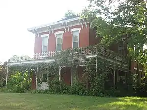
 The James Culbertson Reynolds House in Monticello | |
 Location in White County | |
| Coordinates: 40°44′55″N 86°46′14″W | |
| Country | United States |
| State | Indiana |
| County | White |
| Government | |
| • Type | Indiana township |
| Area | |
| • Total | 43.81 sq mi (113.5 km2) |
| • Land | 41.67 sq mi (107.9 km2) |
| • Water | 2.14 sq mi (5.5 km2) 4.88% |
| Elevation | 679 ft (207 m) |
| Population (2010) | |
| • Total | 9,906 |
| • Density | 237.7/sq mi (91.8/km2) |
| ZIP codes | 47929, 47960 |
| GNIS feature ID | 453939 |
Union Township was organized in 1834.[2]
Geography
According to the 2010 census, the township has a total area of 43.81 square miles (113.5 km2), of which 41.67 square miles (107.9 km2) (or 95.12%) is land and 2.14 square miles (5.5 km2) (or 4.88%) is water.[1]
Cities, towns, villages
Unincorporated towns
- Cedar Point at 40.708928°N 86.760289°W
- East Monticello at 40.746150°N 86.753345°W
- Golden Hill at 40.710316°N 86.760567°W
- Guernsey at 40.800317°N 86.812791°W
- Indiana Beach at 40.791428°N 86.768068°W
(This list is based on USGS data and may include former settlements.)
Adjacent townships
- Liberty Township (north)
- Lincoln Township (east)
- Jefferson Township, Carroll County (southeast)
- Big Creek Township (southwest)
- Honey Creek Township (west)
- Monon Township (northwest)
Cemeteries
The township contains these two cemeteries: Cutler and River View.
Airports and landing strips
- Dittman Airport
- White County Airport
Rivers
Landmarks
- Monticello City Park
- The White County Asylum was listed on the National Register of Historic Places in 2010.[3]
Education
- Twin Lakes School Corporation
Union Township is served by the Monticello-Union Township Public Library.[4]
Political districts
- Indiana's 4th congressional district
- State House District 15
- State House District 16
- State Senate District 07
References
- United States Census Bureau 2007 TIGER/Line Shapefiles
- United States Board on Geographic Names (GNIS)
- IndianaMap
- "Population, Housing Units, Area, and Density: 2010 - County -- County Subdivision and Place -- 2010 Census Summary File 1". United States Census. Archived from the original on February 12, 2020. Retrieved May 10, 2013.
- Hamelle, W. H. (1915). A Standard History of White County, Indiana: An Authentic Narrative of the Past, with an Extended Survey of Modern Developments in the Progress of Town and Country. Unigraphic. p. 191.
- "National Register of Historic Places Listings". Weekly List of Actions Taken on Properties: 9/20/10 through 9/24/10. National Park Service. October 1, 2010.
- "Indiana public library directory" (PDF). Indiana State Library. Retrieved March 15, 2018.
This article is issued from Wikipedia. The text is licensed under Creative Commons - Attribution - Sharealike. Additional terms may apply for the media files.