Upper Mount Gravatt, Queensland
Upper Mount Gravatt is a southern suburb in the City of Brisbane, Queensland, Australia.[3] In the 2016 census, Upper Mount Gravatt had a population of 9,241 people.[1]
| Upper Mount Gravatt Brisbane, Queensland | |||||||||||||||
|---|---|---|---|---|---|---|---|---|---|---|---|---|---|---|---|
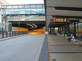
 Busway station | |||||||||||||||
 Upper Mount Gravatt | |||||||||||||||
| Coordinates | 27.5552°S 153.0797°E | ||||||||||||||
| Population | 9,241 (2016 census)[1] | ||||||||||||||
| • Density | 2,149/km2 (5,570/sq mi) | ||||||||||||||
| Postcode(s) | 4122 | ||||||||||||||
| Area | 4.3 km2 (1.7 sq mi) | ||||||||||||||
| Time zone | AEST (UTC+10:00) | ||||||||||||||
| Location | 12.5 km (8 mi) SSE of Brisbane GPO | ||||||||||||||
| LGA(s) | City of Brisbane (MacGregor Ward)[2] | ||||||||||||||
| State electorate(s) | Mansfield | ||||||||||||||
| Federal division(s) | Bonner | ||||||||||||||
| |||||||||||||||
Geography
Upper Mount Gravatt is south of Mount Gravatt. It has increasingly become an important centre in the last 15 years. Logan Road and the Pacific Motorway run through the area, in addition to the South-East Busway.

Together with Indooroopilly in the west, Chermside, on the north-side, and Carindale in the southeast the suburb has been described as a mini-Central business district (CBD). It contains the State Netball Centre, a major police district station and a regional Australian Taxation Office.
Upper Mount Gravatt has long been one of the major centres outside the CBD, especially for those who reside on the south of the city.
Westfield Mt Gravatt, a major shopping centre, is a regional "hub", containing services and popular restaurants, with a bus interchange and the Upper Mount Gravatt Busway Station immediately below it. It is on the southern corner of Logan Road and Kessels Road (27.5621°S 153.08180°E).[4]
History
Upper Mount Gravatt State School opened on 1 October 1929. It has also been called Mount Gravatt Upper State School.[5][6]
St Bernard's School was established on 24 January 1953 by the Sisters of St Joseph of the Sacred Heart under principal Sister Juliana. Mrs Doreen Bazzo was the first lay principal. The first building on the site was a combined church and school, but later moved into separate school buildings.[5][7]
St Joseph's High School for Girls was established in 1964 in Holland Park by the Sisters of St Joseph of the Sacred Heart. In 1970, the school was relocated to Klumpp Road (onto the site also occupied by St Bernard's School and Clairvaux College) and renamed MacKillop College.[5][8]
Clairvaux College was established by the Christian Brothers on 1 February 1966 on part of the 10-acre (4.0 ha) site already partially occupied by St Bernard's School.[5][8]
Westfield Mt Gravatt was opened as one of Brisbane's largest shopping centre on 1 October 1970 by Queensland Premier Joh Bjelke-Petersen. It cost $10 million and occupied a 28-acre (11 ha).[9][10]
The Garden City Library was established by the Brisbane City Council as one of the initial tenants and the library had a major refurbishment in 1996.[11]
St Catherine's Catholic Primary School was established on 4 March 1973 by the Presentation Sisters. It was officially opened by Archbishop Francis Rush.[5][12] In 1979, the closure of a nearby school led to a large increase in enrolments. In 1986, the first lay principal was appointed.[12]
In 1985, MacKillop College (a girls' school) and Clairvaux College (a boys' school) were combined to form Clairvaux Mackillop College.[5]
Demographics
In the 2011 census, the population of Upper Mount Gravatt was 8,851, 51.1% female and 48.9% male.The median age of the Upper Mount Gravatt population was 34 years, 3 years below the Australian median. 59.4% of people living in Upper Mount Gravatt were born in Australia, compared to the national average of 69.8%; the next most common countries of birth were New Zealand 3.3%, China 3.1%, India 2.9%, England 2.7%, Korea, Republic of 1.4%. 67% of people spoke only English at home; the next most common languages were 4.1% Mandarin, 2% Cantonese, 1.4% Korean, 1.4% Arabic, 1.1% Greek.[13]
In the 2016 census, Upper Mount Gravatt had a population of 9,241 people.[1]
Education
Upper Mount Gravatt State School is a government primary (Prep-6) school for boys and girls at 1899 Logan Road (27.5564°S 153.0799°E).[14][15] In 2018, the school had an enrolment of 507 students with 35 teachers (33 full-time equivalent) and 22 non-teaching staff (15 full-time equivalent).[16] It includes a special education program.[14]
St Bernard's School is a Catholic primary (Prep-6) school for boys and girls at 1823 Logan Road (27.5541°S 153.0795°E).[14][17] In 2018, the school had an enrolment of 366 students with 28 teachers (23 full-time equivalent) and 19 non-teaching staff (9 full-time equivalent).[16]
St Catherine's Catholic Primary School is a Catholic primary (Prep-6) school for boys and girls at 388 Newnham Road (27.5514°S 153.0929°E).[14][18] In 2018, the school had an enrolment of 512 students with 35 teachers (30 full-time equivalent) and 20 non-teaching staff (13 full-time equivalent).[16]
Clairvaux Mackillop College is a Catholic secondary (7-12) school for boys and girls at Klumpp Road (27.5528°S 153.0778°E).[14][19] In 2018, the school had an enrolment of 1,265 students with 110 teachers (106 full-time equivalent) and 52 non-teaching staff (43 full-time equivalent).[16]
There is no government secondary school in Upper Mount Gravatt. The nearest government secondary schools are Mount Gravatt State High School in neighbouring Mount Gravatt to the north-west, Mansfield State High School in neighbouring Mansfield to the north-east, and MacGregor State High School in neighbouring MacGregor to the south-west.[20]
Amenities

.jpg.webp)
The Brisbane City Council operates a public library at Westfield Mt Gravatt (27.5613°S 153.0810°E).[21]
Upper Mount Gravatt is also home to the Mount Gravatt Vultures, a Queensland Australian Football League Club on Klumpp Road.[22] The club were premiers in 2007.[23]
There is also the Hibiscus Sporting Complex and the Mount Gravatt PCYC on the same road.
References
- Australian Bureau of Statistics (27 June 2017). "Upper Mount Gravatt (SSC)". 2016 Census QuickStats. Retrieved 20 October 2018.
- "MacGregor Ward". Brisbane City Council. Archived from the original on 12 March 2017. Retrieved 12 March 2017.
- "Upper Mount Gravatt – suburb in City of Brisbane (entry 47606)". Queensland Place Names. Queensland Government. Retrieved 6 March 2022.
- Google (11 March 2022). "Westfield Garden City" (Map). Google Maps. Google. Retrieved 11 March 2022.
- Queensland Family History Society (2010), Queensland schools past and present (Version 1.01 ed.), Queensland Family History Society, ISBN 978-1-921171-26-0
- "Our school". Upper Mount Gravatt State School. 11 March 2020. Archived from the original on 3 March 2022. Retrieved 11 March 2022.
- "Our History". St Bernard's Primary School Upper Mt Gravatt. Archived from the original on 5 March 2022. Retrieved 11 March 2022.
- "Our Proud History". Clairvaux Mackillop College. Archived from the original on 15 March 2016. Retrieved 11 March 2022.
- "D. J. complex to open". The Canberra Times. Vol. 45, no. 12, 709. Australian Capital Territory, Australia. 29 September 1970. p. 17. Archived from the original on 11 March 2022. Retrieved 11 March 2022 – via National Library of Australia.
- "50 Years Anniversary". Westfield Garden City (1 min 32 sec video with audio). 9 October 2020. Archived from the original on 11 March 2022. Retrieved 11 March 2022 – via Facebook.
- "Public Libraries Statistical Bulletin 2016-17" (PDF). Public Libraries Connect. State Library of Queensland. November 2017. p. 11. Archived (PDF) from the original on 30 January 2018. Retrieved 30 January 2018.
- "School History". St Catherine's Catholic Primary School. Archived from the original on 5 March 2022. Retrieved 11 March 2022.
- Australian Bureau of Statistics (31 October 2012). "Upper Mount Gravatt (SSC)". 2011 Census QuickStats. Retrieved 11 March 2022.
- "State and non-state school details". Queensland Government. 9 July 2018. Archived from the original on 21 November 2018. Retrieved 21 November 2018.
- "Upper Mount Gravatt State School". Upper Mount Gravatt State School. 11 March 2020. Archived from the original on 3 March 2022. Retrieved 11 March 2022.
- "ACARA School Profile 2018". Australian Curriculum, Assessment and Reporting Authority. Archived from the original on 27 August 2020. Retrieved 28 January 2020.
- "St Bernard's Primary School Upper Mt Gravatt". St Bernard's Primary School Upper Mt Gravatt. Archived from the original on 5 March 2022. Retrieved 11 March 2022.
- "St Catherine's Catholic Primary School". St Catherine's Catholic Primary School. Archived from the original on 5 March 2022. Retrieved 11 March 2022.
- "Clairvaux Mackillop College". Clairvaux Mackillop College. Archived from the original on 3 March 2022. Retrieved 11 March 2022.
- "Queensland Globe". State of Queensland. Retrieved 11 March 2022.
- "Library opening hours and locations". Brisbane City Council. 3 January 2018. Archived from the original on 30 January 2018. Retrieved 30 January 2018.
- "Mt Gravatt Vultures". Archived from the original on 6 November 2016. Retrieved 21 February 2017.
- "AFL Queensland Premiers". Archived from the original on 22 February 2017. Retrieved 21 February 2017.
External links
- "Upper Mount Gravatt". Queensland Places. Centre for the Government of Queensland, University of Queensland.