Vieux-Boucau-les-Bains
Vieux-Boucau-les-Bains (French pronunciation: [vjø buko le bɛ̃], in Gascon: Lo Bocau Vielh) is a commune in the Landes department in Nouvelle-Aquitaine in southwestern France.[3]
Vieux-Boucau-les-Bains | |
|---|---|
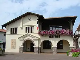 Town hall | |
Location of Vieux-Boucau-les-Bains | |
 Vieux-Boucau-les-Bains  Vieux-Boucau-les-Bains | |
| Coordinates: 43°47′14″N 1°24′11″W | |
| Country | France |
| Region | Nouvelle-Aquitaine |
| Department | Landes |
| Arrondissement | Dax |
| Canton | Marensin Sud |
| Intercommunality | Maremne-Adour-Côte-Sud |
| Government | |
| • Mayor (2020–2026) | Pierre Froustey[1] |
| Area 1 | 4.25 km2 (1.64 sq mi) |
| Population | 1,637 |
| • Density | 390/km2 (1,000/sq mi) |
| Time zone | UTC+01:00 (CET) |
| • Summer (DST) | UTC+02:00 (CEST) |
| INSEE/Postal code | 40328 /40480 |
| Elevation | 0–21 m (0–69 ft) (avg. 3 m or 9.8 ft) |
| 1 French Land Register data, which excludes lakes, ponds, glaciers > 1 km2 (0.386 sq mi or 247 acres) and river estuaries. | |
Vieux-Boucau means "old mouth" as it was where the Adour river used to flow int the Bay of Biscay, and was named “Port d'Albret” in the past. It could have been the first harbor of the Landes coastline, if the Adour river had not been diverted in 1578 for Bayonne.
During the 1970s, an artificial lake and a touristic complex were created and given the town’s old name of "Port d'Albret ". This complex was built in the territory of Vieux-Boucau and the nearby town Soustons. During summer, the population is between 10,000 and 15,000 inhabitants.
There are three beaches along the Atlantic Ocean and one on the lake.
Geography
The commune has the smallest surface of the Landes department.
Population
|
|
See also
References
- "Répertoire national des élus: les maires". data.gouv.fr, Plateforme ouverte des données publiques françaises (in French). 2 December 2020.
- "Populations légales 2020". The National Institute of Statistics and Economic Studies. 29 December 2022.
- INSEE commune file