Virginia statistical areas

The United States Commonwealth of Virginia currently has 19 statistical areas that have been delineated by the Office of Management and Budget (OMB). On March 6, 2020, the OMB delineated four combined statistical areas, 11 metropolitan statistical areas, and four micropolitan statistical areas in Virginia.[1]
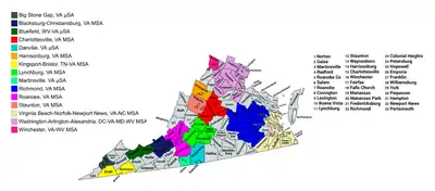
Map of the 15 core-based statistical areas in Virginia.
An enlargeable map of the 15 core-based statistical areas in Virginia.[1]

Statistical areas

The Office of Management and Budget (OMB) has designated more than 1,000 statistical areas for the United States and Puerto Rico.[2] These statistical areas are important geographic delineations of population clusters used by the OMB, the United States Census Bureau, planning organizations, and federal, state, and local government entities.

The OMB defines a core-based statistical area (commonly referred to as a CBSA) as "a statistical geographic entity consisting of the county or counties (or county-equivalents) associated with at least one core[lower-alpha 1] of at least 10,000 population, plus adjacent counties having a high degree of social and economic integration with the core as measured through commuting ties with the counties containing the core."[2] The OMB further divides core-based statistical areas into metropolitan statistical areas (MSAs) that have "a population of at least 50,000" and micropolitan statistical areas (μSAs) that have "a population of at least 10,000, but less than 50,000."[2]

The OMB defines a combined statistical area (CSA) as "a geographic entity consisting of two or more adjacent core-based statistical areas with employment interchange measures[lower-alpha 2] of at least 15%."[2] The primary statistical areas (PSAs) include all combined statistical areas and any core-based statistical area that is not a constituent of a combined statistical area.

Table

The table below describes the 19 United States statistical areas, 95 counties, and 38 independent cities of the Commonwealth of Virginia with the following information:[3]

  1. The combined statistical area (CSA) as designated by the OMB.[1]
  2. The CSA population according to 2019 US Census Bureau population estimates.[4]
  3. The core based statistical area (CBSA)[2] as designated by the OMB.[1]
  4. The CBSA population according to 2019 US Census Bureau population estimates [4]
  5. The county name
  6. The county population according to 2019 US Census Bureau population estimates [4]
  7. The Metropolitan Division name, if applicable[1]
  8. The Metropolitan Division population according to 2019 US Census Bureau population estimates [4]
The 19 United States statistical areas, 95 counties, and 38 independent cities of the Commonwealth of Virginia

Combined Statistical Area 2019 Population Core Based Statistical Area 2019 Population County 2019 Population Metropolitan Division 2019 Population
Washington-Baltimore-Arlington, DC-MD-VA-WV-PA CSA 9,814,928
3,159,639
Washington-Arlington-Alexandria, DC-VA-MD-WV MSA 6,280,487
3,042,248
Fairfax County, Virginia 1,147,532 Washington-Arlington-Alexandria, DC-VA-MD-WV MD 4,970,252
3,042,248
Prince George's County, Maryland 909,327
District of Columbia 705,749
Prince William County, Virginia 470,335
Loudoun County, Virginia 413,538
Arlington County, Virginia 236,842
Charles County, Maryland 163,257
City of Alexandria, Virginia 159,428
Stafford County, Virginia 152,882
Spotsylvania County, Virginia 136,215
Calvert County, Maryland 92,525
Fauquier County, Virginia 71,222
Jefferson County, West Virginia 57,146
Culpeper County, Virginia 52,605
City of Manassas, Virginia 41,085
Warren County, Virginia 40,164
City of Fredericksburg, Virginia 29,036
City of Fairfax, Virginia 24,019
City of Manassas Park, Virginia 17,478
Clarke County, Virginia 14,619
City of Falls Church, Virginia 14,617
Madison County, Virginia 13,261
Rappahannock County, Virginia 7,370
Montgomery County, Maryland 1,050,688 Frederick-Gaithersburg-Rockville, MD MD 1,310,235
Frederick County, Maryland 259,547
Baltimore-Towson, MD MSA 2,800,053 Baltimore County, Maryland 827,370 none
Baltimore City, Maryland 593,490
Anne Arundel County, Maryland 579,234
Howard County, Maryland 325,690
Harford County, Maryland 255,441
Carroll County, Maryland 168,447
Queen Anne's County, Maryland 50,381
Hagerstown-Martinsburg, MD-WV MSA 288,104 Washington County, Maryland 151,049
Berkeley County, West Virginia 119,171
Morgan County, West Virginia 17,884
Chambersburg-Waynesboro, PA MSA 155,027 Franklin County, Pennsylvania 155,027
Winchester, VA-WV MSA 140,566
117,391
Frederick County, Virginia 89,313
City of Winchester, Virginia 28,078
Hampshire County, West Virginia 23,175
California-Lexington Park, MD MSA 113,510 St. Mary's County, Maryland 113,510
Easton, MD μSA 37,181 Talbot County, Maryland 37,181
Virginia Beach-Norfolk, VA-NC CSA 1,857,626
1,718,709
Virginia Beach-Norfolk-Newport News, VA-NC MSA 1,768,064
1,718,709
City of Virginia Beach, Virginia 449,974
City of Chesapeake, Virginia 244,835
City of Norfolk, Virginia 242,742
City of Newport News, Virginia 179,225
City of Hampton, Virginia 134,510
City of Portsmouth, Virginia 94,398
City of Suffolk, Virginia 92,108
James City County, Virginia 76,523
York County, Virginia 68,280
Gloucester County, Virginia 37,348
Isle of Wight County, Virginia 37,109
Currituck County, North Carolina 27,072
Southampton County, Virginia 17,631
City of Williamsburg, Virginia 14,954
City of Poquoson, Virginia 12,271
Gates County, North Carolina 11,573
Camden County, North Carolina 10,710
Mathews County, Virginia 8,834
City of Franklin, Virginia 7,967
Elizabeth City, NC μSA 53,061 Pasquotank County, North Carolina 39,639
Perquimans County, North Carolina 13,422
Kill Devil Hills, NC μSA 36,501 Dare County, North Carolina 36,501
none Richmond, VA MSA 1,291,900 Chesterfield County, Virginia 352,802
Henrico County, Virginia 330,818
City of Richmond, Virginia 230,436
Hanover County, Virginia 107,766
Prince George County, Virginia 38,353
City of Petersburg, Virginia 31,346
Powhatan County, Virginia 29,652
Dinwiddie County, Virginia 28,544
Goochland County, Virginia 23,753
New Kent County, Virginia 23,091
City of Hopewell, Virginia 22,529
City of Colonial Heights, Virginia 17,370
King William County, Virginia 17,148
Amelia County, Virginia 13,145
Sussex County, Virginia 11,159
King and Queen County, Virginia 7,025
Charles City County, Virginia 6,963
Roanoke, VA MSA 313,222 City of Roanoke, Virginia 99,143
Roanoke County, Virginia 94,186
Franklin County, Virginia 56,042
Botetourt County, Virginia 33,419
City of Salem, Virginia 25,301
Craig County, Virginia 5,131
Lynchburg, VA MSA 263,566 City of Lynchburg, Virginia 82,168
Bedford County, Virginia 78,997
Campbell County, Virginia 54,885
Amherst County, Virginia 31,605
Appomattox County, Virginia 15,911
Harrisonburg, VA CSA 258,084 Harrisonburg, VA MSA 134,964 Rockingham County, Virginia 81,948
City of Harrisonburg, Virginia 53,016
Staunton, VA MSA 123,120 Augusta County, Virginia 75,558
City of Staunton, Virginia 24,932
City of Waynesboro, Virginia 22,630
none Charlottesville, VA MSA 218,615 Albemarle County, Virginia 109,330
City of Charlottesville, Virginia 47,266
Fluvanna County, Virginia 27,270
Greene County, Virginia 19,819
Nelson County, Virginia 14,930
Blacksburg-Christiansburg, VA MSA 167,531 Montgomery County, Virginia 98,535
Pulaski County, Virginia 34,027
City of Radford, Virginia 18,249
Giles County, Virginia 16,720
Danville, VA μSA 100,398 Pittsylvania County, Virginia 60,354
City of Danville, Virginia 40,044
Johnson City-Kingsport-Bristol, TN-VA CSA 510,990
92,068
Kingsport-Bristol, TN-VA MSA 306,946
92,068
Sullivan County, Tennessee 158,348
Hawkins County, Tennessee 56,530
Washington County, Virginia 53,740
Scott County, Virginia 21,566
City of Bristol, Virginia 16,762
Johnson City, TN MSA 204,044 Washington County, Tennessee 129,375
Carter County, Tennessee 56,786
Unicoi County, Tennessee 17,883
none Martinsville, VA μSA 63,111 Henry County, Virginia 50,557
City of Martinsville, Virginia 12,554
Bluefield, WV-VA μSA 105,633
46,875
Mercer County, West Virginia 58,758
Tazewell County, Virginia 40,595
Bland County, Virginia 6,280
Big Stone Gap, VA μSA 41,364 Wise County, Virginia 37,383
City of Norton, Virginia 3,981
none Shenandoah County, Virginia 43,616
Louisa County, Virginia 37,591
Orange County, Virginia 37,051
Halifax County, Virginia 33,911
Accomack County, Virginia 32,316
Caroline County, Virginia 30,725
Mecklenburg County, Virginia 30,587
Smyth County, Virginia 30,104
Carroll County, Virginia 29,791
Wythe County, Virginia 28,684
King George County, Virginia 26,836
Russell County, Virginia 26,586
Page County, Virginia 23,902
Lee County, Virginia 23,423
Prince Edward County, Virginia 22,802
Rockbridge County, Virginia 22,573
Buchanan County, Virginia 21,004
Westmoreland County, Virginia 18,015
Patrick County, Virginia 17,608
Buckingham County, Virginia 17,148
Brunswick County, Virginia 16,231
Floyd County, Virginia 15,749
Grayson County, Virginia 15,550
Nottoway County, Virginia 15,232
Alleghany County, Virginia 14,860
Dickenson County, Virginia 14,318
Lunenburg County, Virginia 12,196
Northumberland County, Virginia 12,095
Charlotte County, Virginia 11,880
Northampton County, Virginia 11,710
Greensville County, Virginia 11,336
Essex County, Virginia 10,953
Lancaster County, Virginia 10,603
Middlesex County, Virginia 10,582
Cumberland County, Virginia 9,932
Richmond County, Virginia 9,023
City of Lexington, Virginia 7,446
City of Buena Vista, Virginia 6,478
Surry County, Virginia 6,422
City of Galax, Virginia 6,347
City of Covington, Virginia 5,538
City of Emporia, Virginia 5,346
Bath County, Virginia 4,147
Highland County, Virginia 2,190
Commonwealth of Virginia 8,535,519

See also

Notes

  1. The OMB defines a core as "a densely settled concentration of population, comprising an Urban Area (of 10,000 or more population) delineated by the Census Bureau, around which a core-based statistical area is delineated."[2]
  2. The OMB defines the employment interchange measure as "the sum of the percentage of workers living in the smaller entity who work in the larger entity plus the percentage of employment in the smaller entity that is accounted for by workers who reside in the larger entity."[2]

References

  1. Revised Delineations of Metropolitan Statistical Areas, Micropolitan Statistical Areas, and Combined Statistical Areas, and Guidance on Uses of the Delineations of These Areas (March 6, 2020). "0MB BULLETIN NO. 20-01" (PDF). Office of Management and Budget. Retrieved December 15, 2021.{{cite web}}: CS1 maint: multiple names: authors list (link)
  2. "2020 Standards for Delineating Core Based Statistical Areas". Office of Management and Budget. July 16, 2021. Retrieved December 15, 2021.
  3. An out-of-state area and its population are displayed in green. An area that extends into more than one state is displayed in teal. A teal population number over a black population number show the total population versus the in-state population.
  4. "Annual Estimates of the Resident Population for Counties in the United States: April 1, 2010 to July 1, 2019". United States Census Bureau, Population Division. April 2020. Retrieved April 9, 2020.

37.5215°N 78.8537°W / 37.5215; -78.8537 (Commonwealth of Virginia)

This article is issued from Wikipedia. The text is licensed under Creative Commons - Attribution - Sharealike. Additional terms may apply for the media files.