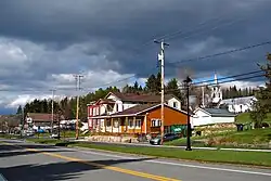
Montcalm, Quebec
Montcalm is a municipality in the Les Laurentides Regional County Municipality of Quebec southeast of Mont-Tremblant. The main population centre in Montcalm is the village of Weir.
Montcalm | |
|---|---|
 Weir | |
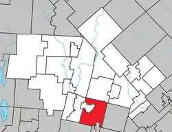 Location within Les Laurentides RCM | |
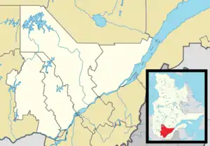 Montcalm Location in central Quebec | |
| Coordinates: 45°58′N 74°30′W[1] | |
| Country | |
| Province | |
| Region | Laurentides |
| RCM | Les Laurentides |
| Constituted | March 6, 1907 |
| Government | |
| • Mayor | Steven Larose |
| • Federal riding | Laurentides—Labelle |
| • Prov. riding | Argenteuil |
| Area | |
| • Total | 129.30 km2 (49.92 sq mi) |
| • Land | 117.18 km2 (45.24 sq mi) |
| Population (2011)[3] | |
| • Total | 619 |
| • Density | 5.3/km2 (14/sq mi) |
| • Pop 2006-2011 | |
| • Dwellings | 663 |
| Time zone | UTC−5 (EST) |
| • Summer (DST) | UTC−4 (EDT) |
| Postal code(s) | |
| Area code | 819 |
| Highways | |
| Website | www.municipalite. montcalm.qc.ca |
Demographics
Population trend:[4]
- Population in 2011: 619 (2006 to 2011 population change: -5.1%)
- Population in 2006: 652
- Population in 2001: 534
- Population in 1996: 449
- Population in 1991: 369
Private dwellings occupied by usual residents: 308 (total dwellings: 663)
Mother tongue:
- English as first language: 25%
- French as first language: 73.5%
- English and French as first language: 1.5%
- Other as first language: 0%
Weir
Weir (45°56′42″N 74°32′58″W) is an unincorporated village in Montcalm, accessible via Quebec Route 364. It is home to a satellite earth station for VSNL International Canada.
Weir is named after William Alexander Weir (1858-1929), a Quebec politician and judge.[5]
Education
Sir Wilfrid Laurier School Board operates English-language schools:
- Arundel Elementary School in Arundel[6]
- Laurentian Regional High School in Lachute serves almost all of Montcalm[7]
References
- "Reference number 274200 in Banque de noms de lieux du Québec". toponymie.gouv.qc.ca (in French). Commission de toponymie du Québec.
- "Geographic code 78055 in the official Répertoire des municipalités". www.mamh.gouv.qc.ca (in French). Ministère des Affaires municipales et de l'Habitation.
- "Montcalm, Quebec (Code 2478055) Census Profile". 2011 census. Government of Canada - Statistics Canada.
- Statistics Canada: 1996, 2001, 2006, 2011 census
- Commission de toponymie du Quebec - Weir
- "Arundel Elementary Zone." Sir Wilfrid Laurier School Board. Retrieved on September 16, 2017.
- "LAURENTIAN REGIONAL HS ZONE." Sir Wilfrid Laurier School Board. Retrieved on September 4, 2017.
External links
 Media related to Montcalm, Laurentides, Quebec at Wikimedia Commons
- Municipalité de Montcalm
- Atlas of Canada - Montcalm
- Commission de toponymie du Quebec
Places adjacent to Montcalm, Quebec | |
|---|---|
| Cities/towns | |
|---|---|
| Municipalities | |
| Townships | |
| Parishes | |
| Villages | |
| |
This article is issued from Wikipedia. The text is licensed under Creative Commons - Attribution - Sharealike. Additional terms may apply for the media files.