Whitestone, Alaska
Whitestone is an unincorporated community and census-designated place in Southeast Fairbanks Census Area, Alaska, United States. Its population was 71 as of the 2020 census. This is not to be confused with Whitestone Logging Camp CDP in the Alaskan panhandle.
Whitestone, Alaska | |
|---|---|
 Whitestone, Alaska | |
| Coordinates: 64°09′10″N 145°54′23″W | |
| Country | United States |
| State | Alaska |
| Census Area | Southeast Fairbanks |
| Government | |
| • State senator | Click Bishop (R) |
| • State rep. | Mike Cronk (R) |
| Area | |
| • Total | 7.04 sq mi (18.24 km2) |
| • Land | 7.04 sq mi (18.24 km2) |
| • Water | 0.00 sq mi (0.00 km2) |
| Elevation | 984 ft (300 m) |
| Population (2020) | |
| • Total | 71 |
| • Density | 10.08/sq mi (3.89/km2) |
| Time zone | UTC-9 (Alaska (AKST)) |
| • Summer (DST) | UTC-8 (AKDT) |
| Area code | 907 |
| GNIS feature ID | 2582719[2] |
Geography
According to the U.S. Census Bureau, the community has an area of 7.065 square miles (18.30 km2), all of it land.[3]
Demographics
| Census | Pop. | Note | %± |
|---|---|---|---|
| 2010 | 97 | — | |
| 2020 | 71 | −26.8% | |
| U.S. Decennial Census[4] | |||
Whitestone first appeared on the 2010 U.S. Census as a census-designated place (CDP).
References
- "2020 U.S. Gazetteer Files". United States Census Bureau. Retrieved October 29, 2021.
- "Whitestone Census Designated Place". Geographic Names Information System. United States Geological Survey, United States Department of the Interior.
- "2010 Census Gazetteer Files - Places: Alaska". U.S. Census Bureau. Retrieved January 17, 2017.
- "U.S. Decennial Census". Census.gov. Retrieved June 6, 2013.
Municipalities and communities of Southeast Fairbanks Census Area, Alaska, United States | ||
|---|---|---|
| Cities | 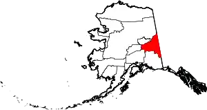 Southeast Fairbanks Census Area map | |
| CDPs | ||
| Former CDPs | ||
| Unincorporated communities | ||
This article is issued from Wikipedia. The text is licensed under Creative Commons - Attribution - Sharealike. Additional terms may apply for the media files.